![](/images/other/stat-length.png)
![Tour Wandern Unknown - Ben Lomond Scotland En boucle - Photo](https://media.geolcdn.com/t/1900/400/ext.pjpeg?maxdim=2&url=https%3A%2F%2Fstatic1.geolcdn.com%2Fsiteimages%2Fupload%2Ffiles%2F1553511878bg_sport_marche.png)
Ben Lomond Scotland En boucle
pierrebourhis
Benutzer
![Länge](/images/other/stat-length.png)
Länge
12,4 km
![Maximale Höhe](https://static1.geolcdn.com/siteimages/upload/files/1508320355ic_sort_altitude_max_24dp.png)
Maximale Höhe
950 m
![Positive Höhendifferenz](https://static1.geolcdn.com/siteimages/upload/files/1508320355ic_sort_den_pos_24dp.png)
Positive Höhendifferenz
932 m
![Km-Effort](/images/other/stat-length.png)
Km-Effort
25 km
![Min. Höhe](https://static1.geolcdn.com/siteimages/upload/files/1508320355ic_sort_altitude_min_24dp.png)
Min. Höhe
16 m
![Negative Höhendifferenz](https://static1.geolcdn.com/siteimages/upload/files/1508320355ic_sort_den_neg_24dp.png)
Negative Höhendifferenz
945 m
![Boucle](https://static1.geolcdn.com/siteimages/upload/files/16400158638029165_repeat_loop_refresh_sync_direction_icon.png)
Boucle
Ja
Erstellungsdatum :
2023-05-22 10:47:22.0
Letzte Änderung :
2023-05-22 17:00:40.251
![Wandern](https://static1.geolcdn.com/sitytour/trail-icons/101.png)
6h11
Schwierigkeit : Medium
![Scannen Sie diesen QR-Code, um die Tour in der SityTrail-Anwendung zu öffnen](https://capi.geolives.com/qq0zvz2zws4bq2lad0pu/sitytour/trails/3669784/qr.png?size=200)
Kostenlosegpshiking-Anwendung
Über SityTrail
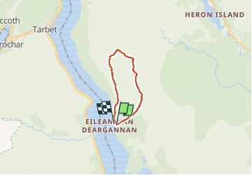
Tour Wandern von 12,4 km verfügbar auf Schottland, Stirling. Diese Tour wird von pierrebourhis vorgeschlagen.
Beschreibung
Très belle rando accessible à tous Effort aboutissant à des vues magnifique
Seule difficulté : anticiper la météo et s équiper comme pour la haute montagne vent froid au sommet Sinon chemin facile pas de difficulté technique
Ort
Land:
United Kingdom
Region :
Schottland
Abteilung/Provinz :
Stirling
Kommune :
Unknown
Standort:
Unknown
Gehen Sie:(Dec)
Gehen Sie:(UTM)
398114 ; 6224121 (30V) N.
Kommentare
Touren in der Umgebung
![Tour Pfad - rowardennan - Beinglas farm - Photo](https://media.geolcdn.com/t/375/260/5142ac2c-7e6c-4318-9ef3-cad5fa817a30.jpg&format=jpg&maxdim=2)
![Pfad Pfad](https://static1.geolcdn.com/sitytour/trail-icons/104.png)
rowardennan - Beinglas farm
Pfad
Sehr leicht
,
Schottland,
Stirling,
United Kingdom
![](/images/other/stat-length.png)
23 km | 30 km-effort
3h 6min
![](https://static1.geolcdn.com/siteimages/upload/files/16400158638029165_repeat_loop_refresh_sync_direction_icon.png)
Nein
![Tour Wandern - Ben lomond scotland - Photo](https://media.geolcdn.com/t/375/260/ext.jpg?maxdim=2&url=https%3A%2F%2Fstatic1.geolcdn.com%2Fsiteimages%2Fupload%2Ffiles%2F1553511878bg_sport_marche.png)
![Wandern Wandern](https://static1.geolcdn.com/sitytour/trail-icons/101.png)
Ben lomond scotland
Wandern
Schwierig
,
Schottland,
Stirling,
United Kingdom
![](/images/other/stat-length.png)
12,5 km | 25 km-effort
4h 49min
![](https://static1.geolcdn.com/siteimages/upload/files/16400158638029165_repeat_loop_refresh_sync_direction_icon.png)
Ja
![Tour Wandern - Ecosse Inversnaid - Photo](https://media.geolcdn.com/t/375/260/ext.jpg?maxdim=2&url=https%3A%2F%2Fstatic1.geolcdn.com%2Fsiteimages%2Fupload%2Ffiles%2F1553511878bg_sport_marche.png)
![Wandern Wandern](https://static1.geolcdn.com/sitytour/trail-icons/101.png)
Ecosse Inversnaid
Wandern
Sehr leicht
,
Schottland,
Stirling,
United Kingdom
![](/images/other/stat-length.png)
14,2 km | 18,6 km-effort
3h 29min
![](https://static1.geolcdn.com/siteimages/upload/files/16400158638029165_repeat_loop_refresh_sync_direction_icon.png)
Nein