![](/images/other/stat-length.png)
![Tour Wandern Montpeyroux - Le château du Bousquet - Photo](https://media.geolcdn.com/t/1900/400/ext.pjpeg?maxdim=2&url=https%3A%2F%2Fstatic1.geolcdn.com%2Fsiteimages%2Fupload%2Ffiles%2F1553511878bg_sport_marche.png)
Le château du Bousquet
Lacaze
Benutzer
![Länge](/images/other/stat-length.png)
Länge
7,8 km
![Maximale Höhe](https://static1.geolcdn.com/siteimages/upload/files/1508320355ic_sort_altitude_max_24dp.png)
Maximale Höhe
964 m
![Positive Höhendifferenz](https://static1.geolcdn.com/siteimages/upload/files/1508320355ic_sort_den_pos_24dp.png)
Positive Höhendifferenz
202 m
![Km-Effort](/images/other/stat-length.png)
Km-Effort
10,5 km
![Min. Höhe](https://static1.geolcdn.com/siteimages/upload/files/1508320355ic_sort_altitude_min_24dp.png)
Min. Höhe
870 m
![Negative Höhendifferenz](https://static1.geolcdn.com/siteimages/upload/files/1508320355ic_sort_den_neg_24dp.png)
Negative Höhendifferenz
201 m
![Boucle](https://static1.geolcdn.com/siteimages/upload/files/16400158638029165_repeat_loop_refresh_sync_direction_icon.png)
Boucle
Ja
Erstellungsdatum :
2014-12-10 00:00:00.0
Letzte Änderung :
2014-12-10 00:00:00.0
![Wandern](https://static1.geolcdn.com/sitytour/trail-icons/101.png)
2h13
Schwierigkeit : Medium
![Scannen Sie diesen QR-Code, um die Tour in der SityTrail-Anwendung zu öffnen](https://capi.geolives.com/qq0zvz2zws4bq2lad0pu/sitytour/trails/364610/qr.png?size=200)
Kostenlosegpshiking-Anwendung
Über SityTrail
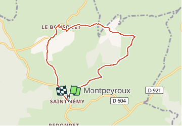
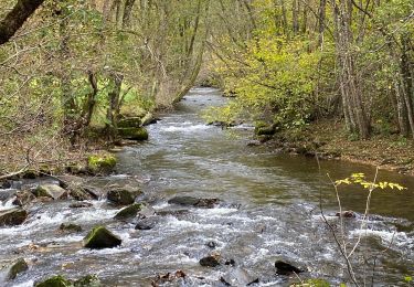
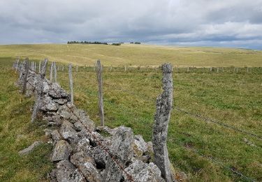
Tour Wandern von 7,8 km verfügbar auf Okzitanien, Aveyron, Montpeyroux. Diese Tour wird von Lacaze vorgeschlagen.
Beschreibung
Départ de St-Remy de Bedène.
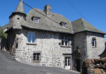
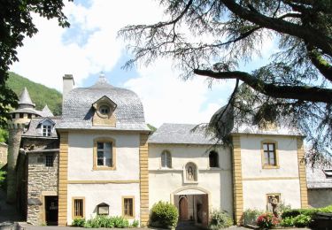
A voir le château après le Bousquet le chemin pour monter à Pinsonnac beaucoup d'eau.De bonnes chaussures sont nécessaires.
Ort
Land:
France
Region :
Okzitanien
Abteilung/Provinz :
Aveyron
Kommune :
Montpeyroux
Standort:
Unknown
Gehen Sie:(Dec)
Gehen Sie:(UTM)
484997 ; 4942855 (31T) N.
Kommentare
Touren in der Umgebung
![Tour sport Soulages-Bonneval - 2024-06-12_14h41m44_visorando-circuit-autour-du-lac-des-galens - Photo](https://media.geolcdn.com/t/375/260/ext.jpg?maxdim=2&url=https%3A%2F%2Fsecurestorage.geolives.com%2Fsitytour%2Ftrail-bg%2Fdefault.jpg)
2024-06-12_14h41m44_visorando-circuit-autour-du-lac-des-galens
sport
Sehr leicht
(2)
Soulages-Bonneval,
Okzitanien,
Aveyron,
France
![](/images/other/stat-length.png)
11,4 km | 14,3 km-effort
Unbekannt
![](https://static1.geolcdn.com/siteimages/upload/files/16400158638029165_repeat_loop_refresh_sync_direction_icon.png)
Ja
![Tour Wandern Curières - hier - Photo](https://media.geolcdn.com/t/375/260/9490aa44-9d58-4d6b-baaf-b8514dbcec92.jpg&format=jpg&maxdim=2)
![Wandern Wandern](https://static1.geolcdn.com/sitytour/trail-icons/101.png)
![Tour Wandern Laguiole - Soulagese Chateau du ousquet - Photo](https://media.geolcdn.com/t/375/260/ed6186cd-dbcb-4b9f-86d8-0190cd90d208.jpg&format=jpg&maxdim=2)
![Wandern Wandern](https://static1.geolcdn.com/sitytour/trail-icons/101.png)
Soulagese Chateau du ousquet
Wandern
Einfach
Laguiole,
Okzitanien,
Aveyron,
France
![](/images/other/stat-length.png)
15,2 km | 19,8 km-effort
5h 48min
![](https://static1.geolcdn.com/siteimages/upload/files/16400158638029165_repeat_loop_refresh_sync_direction_icon.png)
Ja
![Tour Wandern Laguiole - Laguiole Pigasse - Photo](https://media.geolcdn.com/t/375/260/a4af4d41-c2d4-4b57-b319-c0c46e5ff3e0.jpg&format=jpg&maxdim=2)
![Wandern Wandern](https://static1.geolcdn.com/sitytour/trail-icons/101.png)
Laguiole Pigasse
Wandern
Einfach
Laguiole,
Okzitanien,
Aveyron,
France
![](/images/other/stat-length.png)
6,2 km | 8,4 km-effort
1h 47min
![](https://static1.geolcdn.com/siteimages/upload/files/16400158638029165_repeat_loop_refresh_sync_direction_icon.png)
Ja
![Tour Wandern Curières - la croix du Pal - Photo](https://media.geolcdn.com/t/375/260/b0f549f4-0aab-46a5-8cb4-8000321838be.jpg&format=jpg&maxdim=2)
![Wandern Wandern](https://static1.geolcdn.com/sitytour/trail-icons/101.png)
la croix du Pal
Wandern
Medium
Curières,
Okzitanien,
Aveyron,
France
![](/images/other/stat-length.png)
15,2 km | 22 km-effort
4h 29min
![](https://static1.geolcdn.com/siteimages/upload/files/16400158638029165_repeat_loop_refresh_sync_direction_icon.png)
Ja
![Tour Zu Fuß Laguiole - Laguiole PR-5 - Photo](https://media.geolcdn.com/t/375/260/af241a94-94fb-4fe0-a3f0-e2a102ea8c5c.jpeg&format=jpg&maxdim=2)
![Zu Fuß Zu Fuß](https://static1.geolcdn.com/sitytour/trail-icons/100.png)
Laguiole PR-5
Zu Fuß
Einfach
Laguiole,
Okzitanien,
Aveyron,
France
![](/images/other/stat-length.png)
6,3 km | 8,8 km-effort
1h 59min
![](https://static1.geolcdn.com/siteimages/upload/files/16400158638029165_repeat_loop_refresh_sync_direction_icon.png)
Nein
![Tour Zu Fuß Condom-d'Aubrac - Sentier Aubrac - Abbaye de Bonneval - Espalion - Photo](https://media.geolcdn.com/t/375/260/8e3993c7-168b-4f83-9050-caf329372b49.jpeg&format=jpg&maxdim=2)
![Zu Fuß Zu Fuß](https://static1.geolcdn.com/sitytour/trail-icons/100.png)
Sentier Aubrac - Abbaye de Bonneval - Espalion
Zu Fuß
Einfach
Condom-d'Aubrac,
Okzitanien,
Aveyron,
France
![](/images/other/stat-length.png)
12,8 km | 19,2 km-effort
4h 21min
![](https://static1.geolcdn.com/siteimages/upload/files/16400158638029165_repeat_loop_refresh_sync_direction_icon.png)
Nein
![Tour Wandern Laguiole - Lagarrigues Soulages Bonneval - Photo](https://media.geolcdn.com/t/375/260/b8c69d01-75e7-49bc-9232-d9fa6132f6a2.jpg&format=jpg&maxdim=2)
![Wandern Wandern](https://static1.geolcdn.com/sitytour/trail-icons/101.png)
Lagarrigues Soulages Bonneval
Wandern
Sehr leicht
Laguiole,
Okzitanien,
Aveyron,
France
![](/images/other/stat-length.png)
12,5 km | 15,8 km-effort
3h 8min
![](https://static1.geolcdn.com/siteimages/upload/files/16400158638029165_repeat_loop_refresh_sync_direction_icon.png)
Ja
![Tour Wandern Laguiole - Tour de l'Aubrac 4 - Photo](https://media.geolcdn.com/t/375/260/ext.jpg?maxdim=2&url=https%3A%2F%2Fservices.sitytrail.com%2FGeolivesWS%2FDownloadMedia.ashx%3FTrailID%3D821924%26Media%3Dfix__20170902141445.jpg)
![Wandern Wandern](https://static1.geolcdn.com/sitytour/trail-icons/101.png)
Tour de l'Aubrac 4
Wandern
Medium
Laguiole,
Okzitanien,
Aveyron,
France
![](/images/other/stat-length.png)
16,9 km | 22 km-effort
4h 42min
![](https://static1.geolcdn.com/siteimages/upload/files/16400158638029165_repeat_loop_refresh_sync_direction_icon.png)
Nein