![](/images/other/stat-length.png)
![Tour Wandern Maureillas-las-Illas - Las Illas, puis Pruners. - Photo](https://media.geolcdn.com/t/1900/400/ext.pjpeg?maxdim=2&url=https%3A%2F%2Fstatic1.geolcdn.com%2Fsiteimages%2Fupload%2Ffiles%2F1553511878bg_sport_marche.png)
Las Illas, puis Pruners.
Santblasi
Benutzer
![Länge](/images/other/stat-length.png)
![Maximale Höhe](https://static1.geolcdn.com/siteimages/upload/files/1508320355ic_sort_altitude_max_24dp.png)
![Positive Höhendifferenz](https://static1.geolcdn.com/siteimages/upload/files/1508320355ic_sort_den_pos_24dp.png)
![Km-Effort](/images/other/stat-length.png)
![Min. Höhe](https://static1.geolcdn.com/siteimages/upload/files/1508320355ic_sort_altitude_min_24dp.png)
![Negative Höhendifferenz](https://static1.geolcdn.com/siteimages/upload/files/1508320355ic_sort_den_neg_24dp.png)
![Boucle](https://static1.geolcdn.com/siteimages/upload/files/16400158638029165_repeat_loop_refresh_sync_direction_icon.png)
![Wandern](https://static1.geolcdn.com/sitytour/trail-icons/101.png)
4h01
Schwierigkeit : Medium
![Scannen Sie diesen QR-Code, um die Tour in der SityTrail-Anwendung zu öffnen](https://capi.geolives.com/qq0zvz2zws4bq2lad0pu/sitytour/trails/3641832/qr.png?size=200)
Kostenlosegpshiking-Anwendung
Über SityTrail
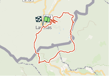
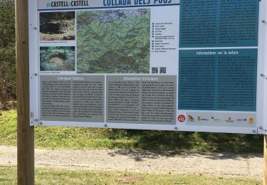
Tour Wandern von 9,9 km verfügbar auf Okzitanien, Ostpyrenäen, Maureillas-las-Illas. Diese Tour wird von Santblasi vorgeschlagen.
Beschreibung
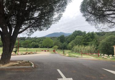
Départ nouveau parking Las Illas. Passer devant le restaurant, suivre chemin des Trabucayres jusqu'au col de Lli.
Borne frontière 557, panneaux mémoriels.
Suivre piste à gauche jusqu'à la GI 505.
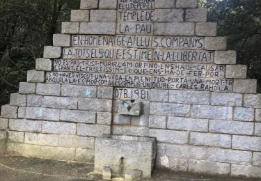
La suivre en montée jusqu'au col de Manrella (monument hommage Lluis Companys). Chercher Borne 559 reculée dans la forêt.
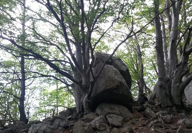
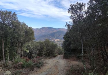
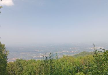
Continuer en montée en suivant les traces oranges jusqu'au sommet, le Puig dels Pruners (vue à 360 degrés). Continuer jusqu'au collet de la Balma (Borne 360). aller en face et prendre piste forestière à gauche pour rejoindre la route de Manruel (pas de marquage.
Descendre jusqu'au parking.
Ort
Kommentare
Touren in der Umgebung
![Tour Wandern Céret - Cretes de Ceret_Fontfrede - Photo](https://media.geolcdn.com/t/375/260/ext.jpg?maxdim=2&url=https%3A%2F%2Fservices.sitytrail.com%2FGeolivesWS%2FDownloadMedia.ashx%3FTrailID%3D574188%26Media%3Dfix__20160524173735.jpg)
![Wandern Wandern](https://static1.geolcdn.com/sitytour/trail-icons/101.png)
Wandern
![](/images/other/stat-length.png)
![](https://static1.geolcdn.com/siteimages/upload/files/16400158638029165_repeat_loop_refresh_sync_direction_icon.png)
![Tour Wandern Maureillas-las-Illas - CERET 66 - les hauts de CERET - ballade en bas Vallespir - dolmen de la Siureda torre Bel Ull - Photo](https://media.geolcdn.com/t/375/260/ext.jpg?maxdim=2&url=https%3A%2F%2Fservices.sitytrail.com%2FGeolivesWS%2FDownloadMedia.ashx%3FTrailID%3D451637%26Media%3D20150729193430.jpg)
![Wandern Wandern](https://static1.geolcdn.com/sitytour/trail-icons/101.png)
Wandern
![](/images/other/stat-length.png)
![](https://static1.geolcdn.com/siteimages/upload/files/16400158638029165_repeat_loop_refresh_sync_direction_icon.png)
![Tour Zu Fuß la Vajol - La Vajol al Santuari i al Puig de les Salines - Photo](https://media.geolcdn.com/t/375/260/74771ece-d1e4-4ad0-a03f-182f9493e580.jpeg&format=jpg&maxdim=2)
![Zu Fuß Zu Fuß](https://static1.geolcdn.com/sitytour/trail-icons/100.png)
Zu Fuß
![](/images/other/stat-length.png)
![](https://static1.geolcdn.com/siteimages/upload/files/16400158638029165_repeat_loop_refresh_sync_direction_icon.png)
![Tour Wandern Maureillas-las-Illas - Las Illas / La Vajol / col de Manrella - Photo](https://media.geolcdn.com/t/375/260/b81992ca-d767-47ac-b6f5-668384262e85.jpg&format=jpg&maxdim=2)
![Wandern Wandern](https://static1.geolcdn.com/sitytour/trail-icons/101.png)
Wandern
![](/images/other/stat-length.png)
![](https://static1.geolcdn.com/siteimages/upload/files/16400158638029165_repeat_loop_refresh_sync_direction_icon.png)
![Tour Wandern Maureillas-las-Illas - RIUNOGUES PORTELL PANISSAR - Photo](https://media.geolcdn.com/t/375/260/4c8ab771-8eed-403d-8d61-1b30ad4c486f.jpg&format=jpg&maxdim=2)
![Wandern Wandern](https://static1.geolcdn.com/sitytour/trail-icons/101.png)
Wandern
![](/images/other/stat-length.png)
![](https://static1.geolcdn.com/siteimages/upload/files/16400158638029165_repeat_loop_refresh_sync_direction_icon.png)
![Tour Wandern Céret - pic des salines . pou del neu . retour via GR10 . solo - Photo](https://media.geolcdn.com/t/375/260/e04fbf64-1095-4bc4-b833-323c74c1b3bc.jpg&format=jpg&maxdim=2)
![Wandern Wandern](https://static1.geolcdn.com/sitytour/trail-icons/101.png)
Wandern
![](/images/other/stat-length.png)
![](https://static1.geolcdn.com/siteimages/upload/files/16400158638029165_repeat_loop_refresh_sync_direction_icon.png)
![Tour Wandern Maureillas-las-Illas - Maureillas - Photo](https://media.geolcdn.com/t/375/260/8db01008-fc45-4765-b00a-20e2a559e880.jpg&format=jpg&maxdim=2)
![Wandern Wandern](https://static1.geolcdn.com/sitytour/trail-icons/101.png)
Wandern
![](/images/other/stat-length.png)
![](https://static1.geolcdn.com/siteimages/upload/files/16400158638029165_repeat_loop_refresh_sync_direction_icon.png)
![Tour Wandern Maureillas-las-Illas - 2022 TRANSPYRÉNÉENNE : Refuge de La ILLIAS - Col du Perthus - com de l’Ouillat ( refuge de L’Albère) - Photo](https://media.geolcdn.com/t/375/260/755b38fa-374d-42c1-bdca-7b44cd953478.jpg&format=jpg&maxdim=2)
![Wandern Wandern](https://static1.geolcdn.com/sitytour/trail-icons/101.png)
Wandern
![](/images/other/stat-length.png)
![](https://static1.geolcdn.com/siteimages/upload/files/16400158638029165_repeat_loop_refresh_sync_direction_icon.png)
![Tour Wandern Céret - Fontfrede -pic des salines par el coll de pois de neu - Photo](https://media.geolcdn.com/t/375/260/bf89040d-a112-43cd-bcd8-2892c4b80052.jpg&format=jpg&maxdim=2)
![Wandern Wandern](https://static1.geolcdn.com/sitytour/trail-icons/101.png)
Wandern
![](/images/other/stat-length.png)
![](https://static1.geolcdn.com/siteimages/upload/files/16400158638029165_repeat_loop_refresh_sync_direction_icon.png)