![](/images/other/stat-length.png)
![Tour Andere Aktivitäten Carcen-Ponson - PDL Carcen - Photo](https://media.geolcdn.com/t/1900/400/ext.pjpeg?maxdim=2&url=https%3A%2F%2Fstatic1.geolcdn.com%2Fsiteimages%2Fupload%2Ffiles%2F1545311037marcheuse_200dpi.jpg)
PDL Carcen
mico40
Benutzer
![Länge](/images/other/stat-length.png)
Länge
8,6 km
![Maximale Höhe](https://static1.geolcdn.com/siteimages/upload/files/1508320355ic_sort_altitude_max_24dp.png)
Maximale Höhe
54 m
![Positive Höhendifferenz](https://static1.geolcdn.com/siteimages/upload/files/1508320355ic_sort_den_pos_24dp.png)
Positive Höhendifferenz
95 m
![Km-Effort](/images/other/stat-length.png)
Km-Effort
9,8 km
![Min. Höhe](https://static1.geolcdn.com/siteimages/upload/files/1508320355ic_sort_altitude_min_24dp.png)
Min. Höhe
31 m
![Negative Höhendifferenz](https://static1.geolcdn.com/siteimages/upload/files/1508320355ic_sort_den_neg_24dp.png)
Negative Höhendifferenz
95 m
![Boucle](https://static1.geolcdn.com/siteimages/upload/files/16400158638029165_repeat_loop_refresh_sync_direction_icon.png)
Boucle
Ja
Erstellungsdatum :
2018-11-30 17:30:42.121
Letzte Änderung :
2018-11-30 17:30:42.128
![Andere Aktivitäten](https://static1.geolcdn.com/sitytour/trail-icons/900.png)
2h00
Schwierigkeit : Unbekannt
![Scannen Sie diesen QR-Code, um die Tour in der SityTrail-Anwendung zu öffnen](https://capi.geolives.com/qq0zvz2zws4bq2lad0pu/sitytour/trails/363593/qr.png?size=200)
Kostenlosegpshiking-Anwendung
Über SityTrail
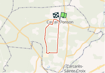
Tour Andere Aktivitäten von 8,6 km verfügbar auf Neu-Aquitanien, Landes, Carcen-Ponson. Diese Tour wird von mico40 vorgeschlagen.
Beschreibung
Randonnée pédestre 5.5 et 10.5km
Visite ferme Photovoltaïque
Visite élevage de poulets
Dégustation de brochettes de poulet mariné
Ort
Land:
France
Region :
Neu-Aquitanien
Abteilung/Provinz :
Landes
Kommune :
Carcen-Ponson
Standort:
Unknown
Gehen Sie:(Dec)
Gehen Sie:(UTM)
676140 ; 4861095 (30T) N.
Kommentare
Touren in der Umgebung
![Tour Mountainbike Tartas - VTT à Tartas - Photo](https://media.geolcdn.com/t/375/260/ext.jpg?maxdim=2&url=https%3A%2F%2Fstatic1.geolcdn.com%2Fsiteimages%2Fupload%2Ffiles%2F1524743154velo.jpg)
![Mountainbike Mountainbike](https://static1.geolcdn.com/sitytour/trail-icons/202.png)
VTT à Tartas
Mountainbike
Schwierig
(1)
Tartas,
Neu-Aquitanien,
Landes,
France
![](/images/other/stat-length.png)
33 km | 37 km-effort
2h 15min
![](https://static1.geolcdn.com/siteimages/upload/files/16400158638029165_repeat_loop_refresh_sync_direction_icon.png)
Ja
![Tour Wandern Beylongue - garricq, rive gauche jusqu'à passerelle poteaux, fontaine des sorcières, le buy, cosse -9.5 - Photo](https://media.geolcdn.com/t/375/260/ext.jpg?maxdim=2&url=https%3A%2F%2Fstatic1.geolcdn.com%2Fsiteimages%2Fupload%2Ffiles%2F1553511878bg_sport_marche.png)
![Wandern Wandern](https://static1.geolcdn.com/sitytour/trail-icons/101.png)
garricq, rive gauche jusqu'à passerelle poteaux, fontaine des sorcières, le b...
Wandern
Medium
(1)
Beylongue,
Neu-Aquitanien,
Landes,
France
![](/images/other/stat-length.png)
9,5 km | 11,2 km-effort
2h 33min
![](https://static1.geolcdn.com/siteimages/upload/files/16400158638029165_repeat_loop_refresh_sync_direction_icon.png)
Ja
![Tour Wandern Beylongue - garricq, rive gauche jusqu'à passerelle poteaux, fontaine des sorcières, le buy, cosse -9.6 - Photo](https://media.geolcdn.com/t/375/260/ext.jpg?maxdim=2&url=https%3A%2F%2Fstatic1.geolcdn.com%2Fsiteimages%2Fupload%2Ffiles%2F1553511878bg_sport_marche.png)
![Wandern Wandern](https://static1.geolcdn.com/sitytour/trail-icons/101.png)
garricq, rive gauche jusqu'à passerelle poteaux, fontaine des sorcières, le b...
Wandern
Medium
(1)
Beylongue,
Neu-Aquitanien,
Landes,
France
![](/images/other/stat-length.png)
9,6 km | 11,4 km-effort
2h 36min
![](https://static1.geolcdn.com/siteimages/upload/files/16400158638029165_repeat_loop_refresh_sync_direction_icon.png)
Ja
![Tour Wandern Beylongue - garricq, rive gauche jusqu'à passerelle poteaux, fontaine des sorcières, le buy, cosse - 9.1 - Photo](https://media.geolcdn.com/t/375/260/ext.jpg?maxdim=2&url=https%3A%2F%2Fstatic1.geolcdn.com%2Fsiteimages%2Fupload%2Ffiles%2F1553511878bg_sport_marche.png)
![Wandern Wandern](https://static1.geolcdn.com/sitytour/trail-icons/101.png)
garricq, rive gauche jusqu'à passerelle poteaux, fontaine des sorcières, le b...
Wandern
Medium
(1)
Beylongue,
Neu-Aquitanien,
Landes,
France
![](/images/other/stat-length.png)
9,1 km | 10,7 km-effort
2h 25min
![](https://static1.geolcdn.com/siteimages/upload/files/16400158638029165_repeat_loop_refresh_sync_direction_icon.png)
Ja
![Tour Wandern Beylongue - garricq, rive gauche jusqu'à passerelle poteaux, fontaine des sorcières - 7 - Photo](https://media.geolcdn.com/t/375/260/ext.jpg?maxdim=2&url=https%3A%2F%2Fstatic1.geolcdn.com%2Fsiteimages%2Fupload%2Ffiles%2F1553511878bg_sport_marche.png)
![Wandern Wandern](https://static1.geolcdn.com/sitytour/trail-icons/101.png)
garricq, rive gauche jusqu'à passerelle poteaux, fontaine des sorcières - 7
Wandern
Einfach
(1)
Beylongue,
Neu-Aquitanien,
Landes,
France
![](/images/other/stat-length.png)
7 km | 8,1 km-effort
1h 30min
![](https://static1.geolcdn.com/siteimages/upload/files/16400158638029165_repeat_loop_refresh_sync_direction_icon.png)
Ja
![Tour Wandern Beylongue - garricq, rive gauche jusqu'à passerelle poteaux, fontaine des sorcières - 7,3 - Photo](https://media.geolcdn.com/t/375/260/ext.jpg?maxdim=2&url=https%3A%2F%2Fstatic1.geolcdn.com%2Fsiteimages%2Fupload%2Ffiles%2F1553511878bg_sport_marche.png)
![Wandern Wandern](https://static1.geolcdn.com/sitytour/trail-icons/101.png)
garricq, rive gauche jusqu'à passerelle poteaux, fontaine des sorcières - 7,3
Wandern
Medium
(1)
Beylongue,
Neu-Aquitanien,
Landes,
France
![](/images/other/stat-length.png)
7,3 km | 8,5 km-effort
1h 55min
![](https://static1.geolcdn.com/siteimages/upload/files/16400158638029165_repeat_loop_refresh_sync_direction_icon.png)
Ja
![Tour Wandern Beylongue - garricq, rive droite, passerelle poteaux, serres, fontaine des sorcières 9.4 - Photo](https://media.geolcdn.com/t/375/260/658b5eac-0164-41b2-a6ec-0dc6c263ea44.jpg&format=jpg&maxdim=2)
![Wandern Wandern](https://static1.geolcdn.com/sitytour/trail-icons/101.png)
garricq, rive droite, passerelle poteaux, serres, fontaine des sorcières 9.4
Wandern
Medium
Beylongue,
Neu-Aquitanien,
Landes,
France
![](/images/other/stat-length.png)
9,4 km | 10,8 km-effort
2h 0min
![](https://static1.geolcdn.com/siteimages/upload/files/16400158638029165_repeat_loop_refresh_sync_direction_icon.png)
Ja
![Tour Wandern Beylongue - garricq jusqu'au poteau et retour - 5.8 - Photo](https://media.geolcdn.com/t/375/260/658b5eac-0164-41b2-a6ec-0dc6c263ea44.jpg&format=jpg&maxdim=2)
![Wandern Wandern](https://static1.geolcdn.com/sitytour/trail-icons/101.png)
garricq jusqu'au poteau et retour - 5.8
Wandern
Medium
Beylongue,
Neu-Aquitanien,
Landes,
France
![](/images/other/stat-length.png)
5,8 km | 6,3 km-effort
2h 0min
![](https://static1.geolcdn.com/siteimages/upload/files/16400158638029165_repeat_loop_refresh_sync_direction_icon.png)
Ja