![](/images/other/stat-length.png)
![Tour Wandern Castillon - Castillon : Mt Ours - Photo](https://media.geolcdn.com/t/1900/400/18e786f6-adf4-41b3-a67d-83ef4f1666ea.jpg&format=pjpeg&maxdim=2)
Castillon : Mt Ours
ETMU5496
Benutzer
![Länge](/images/other/stat-length.png)
Länge
16,7 km
![Maximale Höhe](https://static1.geolcdn.com/siteimages/upload/files/1508320355ic_sort_altitude_max_24dp.png)
Maximale Höhe
1229 m
![Positive Höhendifferenz](https://static1.geolcdn.com/siteimages/upload/files/1508320355ic_sort_den_pos_24dp.png)
Positive Höhendifferenz
957 m
![Km-Effort](/images/other/stat-length.png)
Km-Effort
29 km
![Min. Höhe](https://static1.geolcdn.com/siteimages/upload/files/1508320355ic_sort_altitude_min_24dp.png)
Min. Höhe
734 m
![Negative Höhendifferenz](https://static1.geolcdn.com/siteimages/upload/files/1508320355ic_sort_den_neg_24dp.png)
Negative Höhendifferenz
955 m
![Boucle](https://static1.geolcdn.com/siteimages/upload/files/16400158638029165_repeat_loop_refresh_sync_direction_icon.png)
Boucle
Ja
Erstellungsdatum :
2023-04-23 06:12:09.0
Letzte Änderung :
2023-04-24 14:13:21.22
![Wandern](https://static1.geolcdn.com/sitytour/trail-icons/101.png)
4h22
Schwierigkeit : Medium
![Scannen Sie diesen QR-Code, um die Tour in der SityTrail-Anwendung zu öffnen](https://capi.geolives.com/qq0zvz2zws4bq2lad0pu/sitytour/trails/3632250/qr.png?size=200)
Kostenlosegpshiking-Anwendung
Über SityTrail
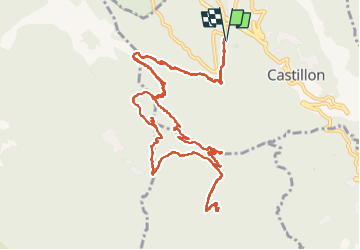
Tour Wandern von 16,7 km verfügbar auf Provence-Alpes-Côte d'Azur, Seealpen, Castillon. Diese Tour wird von ETMU5496 vorgeschlagen.
Beschreibung
Pointe de Siricocca et Pic de Garuche
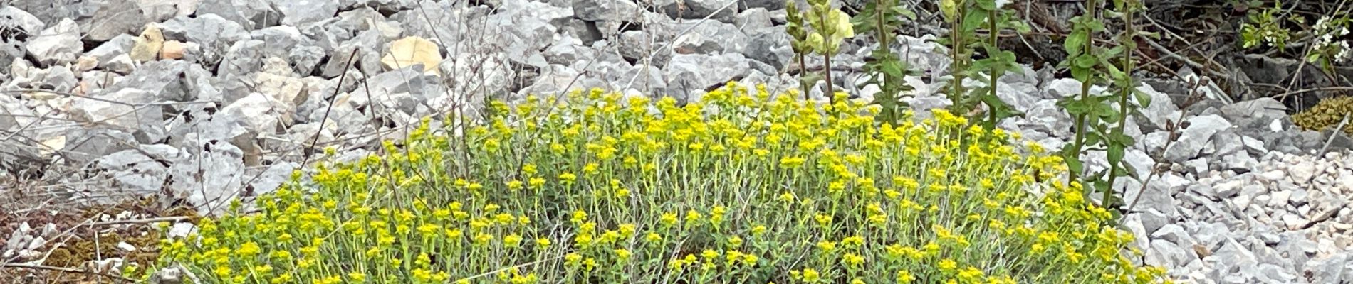
Ort
Land:
France
Region :
Provence-Alpes-Côte d'Azur
Abteilung/Provinz :
Seealpen
Kommune :
Castillon
Standort:
Unknown
Gehen Sie:(Dec)
Gehen Sie:(UTM)
376234 ; 4854959 (32T) N.
Kommentare
Touren in der Umgebung
![Tour Wandern Castellar - Mont Carpano en boucle - Photo](https://media.geolcdn.com/t/375/260/ext.jpg?maxdim=2&url=https%3A%2F%2Fservices.sitytrail.com%2FGeolivesWS%2FDownloadMedia.ashx%3FTrailID%3D232983%26Media%3Dfix__20131116134859.jpg)
![Wandern Wandern](https://static1.geolcdn.com/sitytour/trail-icons/101.png)
Mont Carpano en boucle
Wandern
Medium
(1)
Castellar,
Provence-Alpes-Côte d'Azur,
Seealpen,
France
![](/images/other/stat-length.png)
8,1 km | 14,4 km-effort
3h 18min
![](https://static1.geolcdn.com/siteimages/upload/files/16400158638029165_repeat_loop_refresh_sync_direction_icon.png)
Ja
![Tour Wandern Castellar - Castellar Gramondo Bocca Bassa Col St Bernard Monti réel - Photo](https://media.geolcdn.com/t/375/260/9ef1219a-4e40-4498-97fc-47b72eb8b3af.jpg&format=jpg&maxdim=2)
![Wandern Wandern](https://static1.geolcdn.com/sitytour/trail-icons/101.png)
Castellar Gramondo Bocca Bassa Col St Bernard Monti réel
Wandern
Sehr schwierig
Castellar,
Provence-Alpes-Côte d'Azur,
Seealpen,
France
![](/images/other/stat-length.png)
18,1 km | 36 km-effort
8h 17min
![](https://static1.geolcdn.com/siteimages/upload/files/16400158638029165_repeat_loop_refresh_sync_direction_icon.png)
Ja
![Tour Zu Fuß Peille - Cime de Baudon - Photo](https://media.geolcdn.com/t/375/260/9fe230af-c31e-48d2-a797-a81c449946d4.jpeg&format=jpg&maxdim=2)
![Zu Fuß Zu Fuß](https://static1.geolcdn.com/sitytour/trail-icons/100.png)
Cime de Baudon
Zu Fuß
Einfach
Peille,
Provence-Alpes-Côte d'Azur,
Seealpen,
France
![](/images/other/stat-length.png)
7 km | 14,7 km-effort
3h 20min
![](https://static1.geolcdn.com/siteimages/upload/files/16400158638029165_repeat_loop_refresh_sync_direction_icon.png)
Ja
![Tour Zu Fuß Sospel - Circuit du Cuore - Photo](https://media.geolcdn.com/t/375/260/874c44c6-9655-4f1b-91f3-823e79b13bac.jpeg&format=jpg&maxdim=2)
![Zu Fuß Zu Fuß](https://static1.geolcdn.com/sitytour/trail-icons/100.png)
Circuit du Cuore
Zu Fuß
Medium
Sospel,
Provence-Alpes-Côte d'Azur,
Seealpen,
France
![](/images/other/stat-length.png)
13,7 km | 26 km-effort
5h 54min
![](https://static1.geolcdn.com/siteimages/upload/files/16400158638029165_repeat_loop_refresh_sync_direction_icon.png)
Ja
![Tour Zu Fuß Sospel - Boucle du mont Agaisen - Photo](https://media.geolcdn.com/t/375/260/8adecf07-fe22-4434-84e5-fdafc3720390.jpeg&format=jpg&maxdim=2)
![Zu Fuß Zu Fuß](https://static1.geolcdn.com/sitytour/trail-icons/100.png)
Boucle du mont Agaisen
Zu Fuß
Einfach
Sospel,
Provence-Alpes-Côte d'Azur,
Seealpen,
France
![](/images/other/stat-length.png)
8,7 km | 14,1 km-effort
3h 12min
![](https://static1.geolcdn.com/siteimages/upload/files/16400158638029165_repeat_loop_refresh_sync_direction_icon.png)
Ja
![Tour Zu Fuß Ventimiglia - AM0 - ALPI MARE 0 - Photo](https://media.geolcdn.com/t/375/260/6cc1eb13-113d-4d04-9dbb-12c9f2aaa749.jpeg&format=jpg&maxdim=2)
![Zu Fuß Zu Fuß](https://static1.geolcdn.com/sitytour/trail-icons/100.png)
AM0 - ALPI MARE 0
Zu Fuß
Einfach
Ventimiglia,
Ligurien,
Imperia,
Italy
![](/images/other/stat-length.png)
9,7 km | 13,8 km-effort
3h 8min
![](https://static1.geolcdn.com/siteimages/upload/files/16400158638029165_repeat_loop_refresh_sync_direction_icon.png)
Nein
![Tour Wandern Sospel - Sospel - Le Mont Agaisen - Photo](https://media.geolcdn.com/t/375/260/ext.jpg?maxdim=2&url=https%3A%2F%2Fservices.sitytrail.com%2FGeolivesWS%2FDownloadMedia.ashx%3FTrailID%3D435408%26Media%3Dfix__20150616122103.jpg)
![Wandern Wandern](https://static1.geolcdn.com/sitytour/trail-icons/101.png)
Sospel - Le Mont Agaisen
Wandern
Medium
Sospel,
Provence-Alpes-Côte d'Azur,
Seealpen,
France
![](/images/other/stat-length.png)
9,8 km | 15,7 km-effort
3h 5min
![](https://static1.geolcdn.com/siteimages/upload/files/16400158638029165_repeat_loop_refresh_sync_direction_icon.png)
Ja
![Tour Wandern Peille - Cime de Baudon - Photo](https://media.geolcdn.com/t/375/260/ext.jpg?maxdim=2&url=https%3A%2F%2Fstatic1.geolcdn.com%2Fsiteimages%2Fupload%2Ffiles%2F1553511878bg_sport_marche.png)
![Wandern Wandern](https://static1.geolcdn.com/sitytour/trail-icons/101.png)
Cime de Baudon
Wandern
Medium
(1)
Peille,
Provence-Alpes-Côte d'Azur,
Seealpen,
France
![](/images/other/stat-length.png)
7,8 km | 15,7 km-effort
4h 15min
![](https://static1.geolcdn.com/siteimages/upload/files/16400158638029165_repeat_loop_refresh_sync_direction_icon.png)
Ja
![Tour Wandern Castellar - mont carpano au départ de Castellar - Photo](https://media.geolcdn.com/t/375/260/2bb0ee4e-7242-4d27-af93-c9590a3b2d34.jpg&format=jpg&maxdim=2)
![Wandern Wandern](https://static1.geolcdn.com/sitytour/trail-icons/101.png)
mont carpano au départ de Castellar
Wandern
Medium
(1)
Castellar,
Provence-Alpes-Côte d'Azur,
Seealpen,
France
![](/images/other/stat-length.png)
7,7 km | 13,9 km-effort
5h 14min
![](https://static1.geolcdn.com/siteimages/upload/files/16400158638029165_repeat_loop_refresh_sync_direction_icon.png)
Ja