![](/images/other/stat-length.png)
![Tour Wandern Busy -](https://media.geolcdn.com/t/1900/400/193b0b04-f900-44e1-b6ed-75ba7127a77e.jpg&format=pjpeg&maxdim=2)
"oiseaux" comice
eltonnermou
Benutzer
![Länge](/images/other/stat-length.png)
![Maximale Höhe](https://static1.geolcdn.com/siteimages/upload/files/1508320355ic_sort_altitude_max_24dp.png)
![Positive Höhendifferenz](https://static1.geolcdn.com/siteimages/upload/files/1508320355ic_sort_den_pos_24dp.png)
![Km-Effort](/images/other/stat-length.png)
![Min. Höhe](https://static1.geolcdn.com/siteimages/upload/files/1508320355ic_sort_altitude_min_24dp.png)
![Negative Höhendifferenz](https://static1.geolcdn.com/siteimages/upload/files/1508320355ic_sort_den_neg_24dp.png)
![Boucle](https://static1.geolcdn.com/siteimages/upload/files/16400158638029165_repeat_loop_refresh_sync_direction_icon.png)
![Wandern](https://static1.geolcdn.com/sitytour/trail-icons/101.png)
2h15
Schwierigkeit : Medium
![Scannen Sie diesen QR-Code, um die Tour in der SityTrail-Anwendung zu öffnen](https://capi.geolives.com/qq0zvz2zws4bq2lad0pu/sitytour/trails/3624954/qr.png?size=200)
Kostenlosegpshiking-Anwendung
Über SityTrail
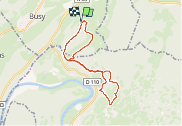
Tour Wandern von 7,9 km verfügbar auf Burgund und Freigrafschaft, Doubs, Busy. Diese Tour wird von eltonnermou vorgeschlagen.
Beschreibung
Parking proximité maison du "Comice".
Cette randonnée guidée nous a fait découvrir le chant des différentes espèces d'oiseaux vivant dans ces différents milieux : boisés, taillis, prairies, etc ...
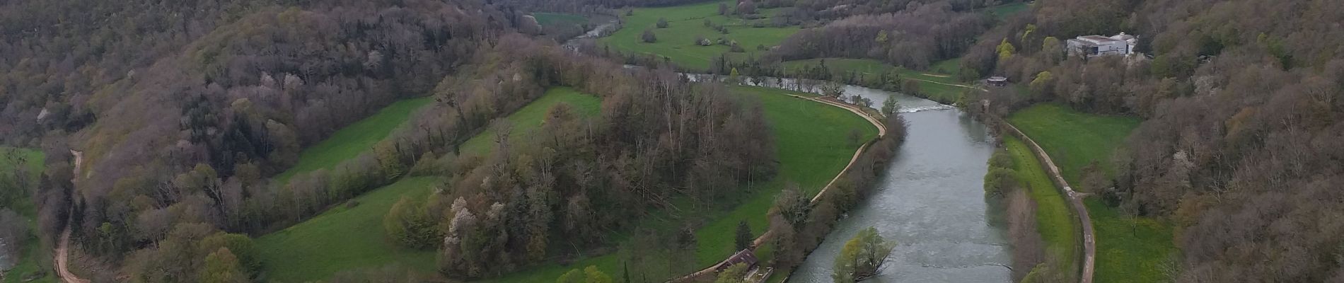
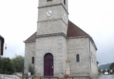
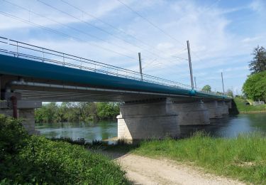
Pour la randonnée : avant d'arrivée à Chenecey, possibilité de faire une pause à la maison de chasse du village. Profitez de la vue offerte au belvédère sur les méandres de la Loue, puis vous passez à proximité de "cavités" typiques des sols karstiques de la région ; prudence aux audacieux(ses) en quête d'aventure.
Vous surprendrez certainement des chamois, fort nombreux sur les escarpements du secteur. A la belle saison, vous pourrez admirer la variété d'une flore abondante.
Foto-Galerie
![Tour Wandern Busy - Tour Wandern Busy -](https://media.geolcdn.com/t/170/100/193b0b04-f900-44e1-b6ed-75ba7127a77e.jpg&format=jpg&maxdim=2)
![Tour Wandern Busy - Tour Wandern Busy -](https://media.geolcdn.com/t/170/100/04169f18-29e3-4866-a46d-e08a33348cfc.jpg&format=jpg&maxdim=2)
Ort
Kommentare
Touren in der Umgebung
![Tour Wandern Beure - Beure de la pisseur au mercureau - Photo](https://media.geolcdn.com/t/375/260/af87c349-0861-4e70-9a13-b157a632bd51.jpg&format=jpg&maxdim=2)
![Wandern Wandern](https://static1.geolcdn.com/sitytour/trail-icons/101.png)
Wandern
![](/images/other/stat-length.png)
![](https://static1.geolcdn.com/siteimages/upload/files/16400158638029165_repeat_loop_refresh_sync_direction_icon.png)
![Tour Wandern Beure -](https://media.geolcdn.com/t/375/260/1d465e36-f50c-4143-b089-4392e69daccf.jpg&format=jpg&maxdim=2)
![Wandern Wandern](https://static1.geolcdn.com/sitytour/trail-icons/101.png)
Wandern
![](/images/other/stat-length.png)
![](https://static1.geolcdn.com/siteimages/upload/files/16400158638029165_repeat_loop_refresh_sync_direction_icon.png)
![Tour Wandern Beure - Beure, fort Planoise, Valmy, Roche trouée, vieille église. - Photo](https://media.geolcdn.com/t/375/260/f17b22e5-5227-4f08-8b37-03856be840af.jpg&format=jpg&maxdim=2)
![Wandern Wandern](https://static1.geolcdn.com/sitytour/trail-icons/101.png)
Wandern
![](/images/other/stat-length.png)
![](https://static1.geolcdn.com/siteimages/upload/files/16400158638029165_repeat_loop_refresh_sync_direction_icon.png)
![Tour Wandern Fontain - fontain - fort de Fontain - forêt de Fontain - Photo](https://media.geolcdn.com/t/375/260/dda8671d-de1b-4872-afba-e5376a2d57f0.jpg&format=jpg&maxdim=2)
![Wandern Wandern](https://static1.geolcdn.com/sitytour/trail-icons/101.png)
Wandern
![](/images/other/stat-length.png)
![](https://static1.geolcdn.com/siteimages/upload/files/16400158638029165_repeat_loop_refresh_sync_direction_icon.png)
![Tour Zu Fuß Busy - Sentier de la Pierre de Vorges - Photo](https://media.geolcdn.com/t/375/260/6f249824-322a-4d94-8931-19d5b1d90e88.jpeg&format=jpg&maxdim=2)
![Zu Fuß Zu Fuß](https://static1.geolcdn.com/sitytour/trail-icons/100.png)
Zu Fuß
![](/images/other/stat-length.png)
![](https://static1.geolcdn.com/siteimages/upload/files/16400158638029165_repeat_loop_refresh_sync_direction_icon.png)
![Tour Zu Fuß Vorges-les-Pins - Sentier des Crêtes - Photo](https://media.geolcdn.com/t/375/260/11000138-aa02-48df-818f-23d3321a98ed.jpeg&format=jpg&maxdim=2)
![Zu Fuß Zu Fuß](https://static1.geolcdn.com/sitytour/trail-icons/100.png)
Zu Fuß
![](/images/other/stat-length.png)
![](https://static1.geolcdn.com/siteimages/upload/files/16400158638029165_repeat_loop_refresh_sync_direction_icon.png)
![Tour Zu Fuß Fontain - Grande Boucle de Fontain - Photo](https://media.geolcdn.com/t/375/260/f1d37a4d-b9db-4571-aaef-737a004f40e0.jpeg&format=jpg&maxdim=2)
![Zu Fuß Zu Fuß](https://static1.geolcdn.com/sitytour/trail-icons/100.png)
Zu Fuß
![](/images/other/stat-length.png)
![](https://static1.geolcdn.com/siteimages/upload/files/16400158638029165_repeat_loop_refresh_sync_direction_icon.png)
![Tour Zu Fuß Fontain - Sentier des Grands Prés - Photo](https://media.geolcdn.com/t/375/260/b5a7d0a4-551b-456d-ac6c-7ab118f9fe97.jpeg&format=jpg&maxdim=2)
![Zu Fuß Zu Fuß](https://static1.geolcdn.com/sitytour/trail-icons/100.png)
Zu Fuß
![](/images/other/stat-length.png)
![](https://static1.geolcdn.com/siteimages/upload/files/16400158638029165_repeat_loop_refresh_sync_direction_icon.png)
![Tour Zu Fuß Grandfontaine - Sentier de Béthanier-la-Marne - Photo](https://media.geolcdn.com/t/375/260/2cb68c4b-5f12-47bc-b1b4-9a02447cfa53.jpeg&format=jpg&maxdim=2)
![Zu Fuß Zu Fuß](https://static1.geolcdn.com/sitytour/trail-icons/100.png)
Zu Fuß
![](/images/other/stat-length.png)
![](https://static1.geolcdn.com/siteimages/upload/files/16400158638029165_repeat_loop_refresh_sync_direction_icon.png)