![](/images/other/stat-length.png)
![Tour Nordic Walking Laxou - Laxou 8 650m +105m - Photo](https://media.geolcdn.com/t/1900/400/ext.pjpeg?maxdim=2&url=https%3A%2F%2Fstatic1.geolcdn.com%2Fsiteimages%2Fupload%2Ffiles%2F1545311037marcheuse_200dpi.jpg)
Laxou 8 650m +105m
DanielROLLET
Benutzer
![Länge](/images/other/stat-length.png)
Länge
8,7 km
![Maximale Höhe](https://static1.geolcdn.com/siteimages/upload/files/1508320355ic_sort_altitude_max_24dp.png)
Maximale Höhe
363 m
![Positive Höhendifferenz](https://static1.geolcdn.com/siteimages/upload/files/1508320355ic_sort_den_pos_24dp.png)
Positive Höhendifferenz
105 m
![Km-Effort](/images/other/stat-length.png)
Km-Effort
10,1 km
![Min. Höhe](https://static1.geolcdn.com/siteimages/upload/files/1508320355ic_sort_altitude_min_24dp.png)
Min. Höhe
299 m
![Negative Höhendifferenz](https://static1.geolcdn.com/siteimages/upload/files/1508320355ic_sort_den_neg_24dp.png)
Negative Höhendifferenz
105 m
![Boucle](https://static1.geolcdn.com/siteimages/upload/files/16400158638029165_repeat_loop_refresh_sync_direction_icon.png)
Boucle
Ja
Erstellungsdatum :
2023-04-08 06:55:28.945
Letzte Änderung :
2023-04-08 13:56:31.663
![Nordic Walking](https://static1.geolcdn.com/sitytour/trail-icons/102.png)
2h00
Schwierigkeit : Sehr leicht
![Scannen Sie diesen QR-Code, um die Tour in der SityTrail-Anwendung zu öffnen](https://capi.geolives.com/qq0zvz2zws4bq2lad0pu/sitytour/trails/3613350/qr.png?size=200)
Kostenlosegpshiking-Anwendung
Über SityTrail
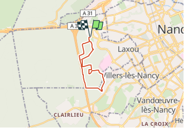
Tour Nordic Walking von 8,7 km verfügbar auf Großer Osten, Mörthe und Mosel, Laxou. Diese Tour wird von DanielROLLET vorgeschlagen.
Beschreibung
2023 04 08 marche nordique Rando Pattes 54 - 7 participants
Beau temps frais
Pause trop longue - circuit pas préparé.
Ort
Land:
France
Region :
Großer Osten
Abteilung/Provinz :
Mörthe und Mosel
Kommune :
Laxou
Standort:
Unknown
Gehen Sie:(Dec)
Gehen Sie:(UTM)
288564 ; 5397023 (32U) N.
Kommentare
Touren in der Umgebung
![Tour Zu Fuß Champigneulles - Circuit G - Photo](https://media.geolcdn.com/t/375/260/367653e8-319c-4965-be92-65937a99215e.jpeg&format=jpg&maxdim=2)
![Zu Fuß Zu Fuß](https://static1.geolcdn.com/sitytour/trail-icons/100.png)
Circuit G
Zu Fuß
Medium
Champigneulles,
Großer Osten,
Mörthe und Mosel,
France
![](/images/other/stat-length.png)
18,7 km | 24 km-effort
5h 24min
![](https://static1.geolcdn.com/siteimages/upload/files/16400158638029165_repeat_loop_refresh_sync_direction_icon.png)
Nein
![Tour Zu Fuß Champigneulles - Circuit du Val Saint-Barthélémy - Photo](https://media.geolcdn.com/t/375/260/199ee8e6-f9b7-4be8-9188-093275697409.jpeg&format=jpg&maxdim=2)
![Zu Fuß Zu Fuß](https://static1.geolcdn.com/sitytour/trail-icons/100.png)
Circuit du Val Saint-Barthélémy
Zu Fuß
Einfach
Champigneulles,
Großer Osten,
Mörthe und Mosel,
France
![](/images/other/stat-length.png)
7 km | 8,6 km-effort
1h 57min
![](https://static1.geolcdn.com/siteimages/upload/files/16400158638029165_repeat_loop_refresh_sync_direction_icon.png)
Ja
![Tour Zu Fuß Champigneulles - Circuit du Noirval - Photo](https://media.geolcdn.com/t/375/260/199ee8e6-f9b7-4be8-9188-093275697409.jpeg&format=jpg&maxdim=2)
![Zu Fuß Zu Fuß](https://static1.geolcdn.com/sitytour/trail-icons/100.png)
Circuit du Noirval
Zu Fuß
Einfach
Champigneulles,
Großer Osten,
Mörthe und Mosel,
France
![](/images/other/stat-length.png)
11,1 km | 13,5 km-effort
3h 4min
![](https://static1.geolcdn.com/siteimages/upload/files/16400158638029165_repeat_loop_refresh_sync_direction_icon.png)
Ja
![Tour Wandern Nancy - Ma dernière avant opération - Photo](https://media.geolcdn.com/t/375/260/ext.jpg?maxdim=2&url=https%3A%2F%2Fstatic1.geolcdn.com%2Fsiteimages%2Fupload%2Ffiles%2F1553511878bg_sport_marche.png)
![Wandern Wandern](https://static1.geolcdn.com/sitytour/trail-icons/101.png)
Ma dernière avant opération
Wandern
Sehr schwierig
(1)
Nancy,
Großer Osten,
Mörthe und Mosel,
France
![](/images/other/stat-length.png)
22 km | 25 km-effort
4h 12min
![](https://static1.geolcdn.com/siteimages/upload/files/16400158638029165_repeat_loop_refresh_sync_direction_icon.png)
Ja
![Tour Wandern Vandœuvre-lès-Nancy - Randonnée USEP 2023 - Photo](https://media.geolcdn.com/t/375/260/ext.jpg?maxdim=2&url=https%3A%2F%2Fstatic1.geolcdn.com%2Fsiteimages%2Fupload%2Ffiles%2F1553511878bg_sport_marche.png)
![Wandern Wandern](https://static1.geolcdn.com/sitytour/trail-icons/101.png)
Randonnée USEP 2023
Wandern
Schwierig
(1)
Vandœuvre-lès-Nancy,
Großer Osten,
Mörthe und Mosel,
France
![](/images/other/stat-length.png)
11,7 km | 15,2 km-effort
3h 27min
![](https://static1.geolcdn.com/siteimages/upload/files/16400158638029165_repeat_loop_refresh_sync_direction_icon.png)
Nein
![Tour Wandern Nancy - Ma rando du jour - Photo](https://media.geolcdn.com/t/375/260/c990ad83-2661-43f9-99e0-4498fd5d020a.jpg&format=jpg&maxdim=2)
![Wandern Wandern](https://static1.geolcdn.com/sitytour/trail-icons/101.png)
Ma rando du jour
Wandern
Schwierig
Nancy,
Großer Osten,
Mörthe und Mosel,
France
![](/images/other/stat-length.png)
35 km | 41 km-effort
5h 55min
![](https://static1.geolcdn.com/siteimages/upload/files/16400158638029165_repeat_loop_refresh_sync_direction_icon.png)
Ja
![Tour Wandern Nancy - Nancy Gondreville Nancy - Photo](https://media.geolcdn.com/t/375/260/171b4f53-1717-4b2e-9789-6c40dd8e1481.jpg&format=jpg&maxdim=2)
![Wandern Wandern](https://static1.geolcdn.com/sitytour/trail-icons/101.png)
Nancy Gondreville Nancy
Wandern
Schwierig
Nancy,
Großer Osten,
Mörthe und Mosel,
France
![](/images/other/stat-length.png)
64 km | 74 km-effort
10h 57min
![](https://static1.geolcdn.com/siteimages/upload/files/16400158638029165_repeat_loop_refresh_sync_direction_icon.png)
Ja
![Tour Wandern Nancy - Nancy Saizeray Jaillon Pierre la Treiche Marion Nancy - Photo](https://media.geolcdn.com/t/375/260/9e40712a-6db3-4fe8-9edd-58851d16cb4f.jpg&format=jpg&maxdim=2)
![Wandern Wandern](https://static1.geolcdn.com/sitytour/trail-icons/101.png)
Nancy Saizeray Jaillon Pierre la Treiche Marion Nancy
Wandern
Schwierig
Nancy,
Großer Osten,
Mörthe und Mosel,
France
![](/images/other/stat-length.png)
73 km | 85 km-effort
12h 13min
![](https://static1.geolcdn.com/siteimages/upload/files/16400158638029165_repeat_loop_refresh_sync_direction_icon.png)
Ja
![Tour Wandern Villers-lès-Nancy - RANDO DUO AVEC ALEXIS - Photo](https://media.geolcdn.com/t/375/260/ext.jpg?maxdim=2&url=https%3A%2F%2Fstatic1.geolcdn.com%2Fsiteimages%2Fupload%2Ffiles%2F1553511878bg_sport_marche.png)
![Wandern Wandern](https://static1.geolcdn.com/sitytour/trail-icons/101.png)
RANDO DUO AVEC ALEXIS
Wandern
Schwierig
(1)
Villers-lès-Nancy,
Großer Osten,
Mörthe und Mosel,
France
![](/images/other/stat-length.png)
38 km | 45 km-effort
10h 19min
![](https://static1.geolcdn.com/siteimages/upload/files/16400158638029165_repeat_loop_refresh_sync_direction_icon.png)
Nein