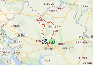
![](/images/other/stat-length.png)
![Tour Wandern Theix-Noyalo - PR_56_Theix-Noyalo_AA_01_Circuit3b_Vers-Corn-Er-Hoet_20230401 - Photo](https://media.geolcdn.com/t/1900/400/53a27219-59ef-468a-9654-2c8ca963d998.jpg&format=pjpeg&maxdim=2)
PR_56_Theix-Noyalo_AA_01_Circuit3b_Vers-Corn-Er-Hoet_20230401
patrickdanilo
Benutzer
![Länge](/images/other/stat-length.png)
Länge
8,3 km
![Maximale Höhe](https://static1.geolcdn.com/siteimages/upload/files/1508320355ic_sort_altitude_max_24dp.png)
Maximale Höhe
56 m
![Positive Höhendifferenz](https://static1.geolcdn.com/siteimages/upload/files/1508320355ic_sort_den_pos_24dp.png)
Positive Höhendifferenz
123 m
![Km-Effort](/images/other/stat-length.png)
Km-Effort
9,9 km
![Min. Höhe](https://static1.geolcdn.com/siteimages/upload/files/1508320355ic_sort_altitude_min_24dp.png)
Min. Höhe
4 m
![Negative Höhendifferenz](https://static1.geolcdn.com/siteimages/upload/files/1508320355ic_sort_den_neg_24dp.png)
Negative Höhendifferenz
121 m
![Boucle](https://static1.geolcdn.com/siteimages/upload/files/16400158638029165_repeat_loop_refresh_sync_direction_icon.png)
Boucle
Ja
Erstellungsdatum :
2023-04-01 08:10:39.101
Letzte Änderung :
2023-09-04 17:31:16.076
![Wandern](https://static1.geolcdn.com/sitytour/trail-icons/101.png)
1h40
Schwierigkeit : Medium
![Scannen Sie diesen QR-Code, um die Tour in der SityTrail-Anwendung zu öffnen](https://capi.geolives.com/qq0zvz2zws4bq2lad0pu/sitytour/trails/3604937/qr.png?size=200)
Kostenlosegpshiking-Anwendung
Über SityTrail
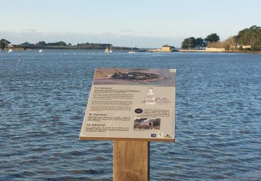
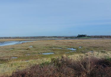
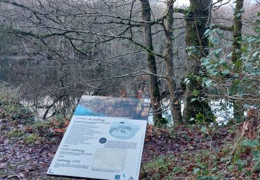
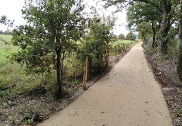
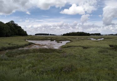
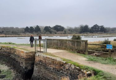
Tour Wandern von 8,3 km verfügbar auf Bretagne, Morbihan, Theix-Noyalo. Diese Tour wird von patrickdanilo vorgeschlagen.
Beschreibung
Randonnée Marche de 8,3 km à découvrir à Bretagne, Morbihan, Theix-Noyalo. Cette randonnée est proposée par patrickdanilo.
Ort
Land:
France
Region :
Bretagne
Abteilung/Provinz :
Morbihan
Kommune :
Theix-Noyalo
Standort:
Unknown
Gehen Sie:(Dec)
Gehen Sie:(UTM)
526359 ; 5275269 (30T) N.
Kommentare
Touren in der Umgebung
![Tour Wandern Treffléan - Bizole - Photo](https://media.geolcdn.com/t/375/260/ext.jpg?maxdim=2&url=https%3A%2F%2Fservices.sitytrail.com%2FGeolivesWS%2FDownloadMedia.ashx%3FTrailID%3D191920%26Media%3Dfb5fe928-9f5d-4af5-aad3-ccb04a0144c1.JPG)
![Wandern Wandern](https://static1.geolcdn.com/sitytour/trail-icons/101.png)
![Tour Wandern Treffléan - PR_56_Trefflean_BA_02_Circuit1b_Chemin-De-Cran_20240507 - Photo](https://media.geolcdn.com/t/375/260/b832eb83-9ae2-4127-a1d1-f2e6e6666b1a.jpg&format=jpg&maxdim=2)
![Wandern Wandern](https://static1.geolcdn.com/sitytour/trail-icons/101.png)
PR_56_Trefflean_BA_02_Circuit1b_Chemin-De-Cran_20240507
Wandern
Einfach
Treffléan,
Bretagne,
Morbihan,
France
![](/images/other/stat-length.png)
5,4 km | 6,5 km-effort
1h 12min
![](https://static1.geolcdn.com/siteimages/upload/files/16400158638029165_repeat_loop_refresh_sync_direction_icon.png)
Ja
![Tour Wandern Treffléan - PR_56_Trefflean_AA_01_Circuit1b_De-La-Chapelle-De-Bizole_20240111 - Photo](https://media.geolcdn.com/t/375/260/33cdd34a-a9e1-478f-975c-2bd4facddb06.jpg&format=jpg&maxdim=2)
![Wandern Wandern](https://static1.geolcdn.com/sitytour/trail-icons/101.png)
PR_56_Trefflean_AA_01_Circuit1b_De-La-Chapelle-De-Bizole_20240111
Wandern
Medium
Treffléan,
Bretagne,
Morbihan,
France
![](/images/other/stat-length.png)
6,4 km | 8,2 km-effort
1h 20min
![](https://static1.geolcdn.com/siteimages/upload/files/16400158638029165_repeat_loop_refresh_sync_direction_icon.png)
Ja
![Tour Wandern Séné - PR_56_Sene_HA_08_Circuit3a_Du-Passage_20231205 - Photo](https://media.geolcdn.com/t/375/260/d5b7643d-c63d-4161-aaf0-6fe7e6e442e1.jpg&format=jpg&maxdim=2)
![Wandern Wandern](https://static1.geolcdn.com/sitytour/trail-icons/101.png)
PR_56_Sene_HA_08_Circuit3a_Du-Passage_20231205
Wandern
Medium
Séné,
Bretagne,
Morbihan,
France
![](/images/other/stat-length.png)
8,5 km | 9,7 km-effort
1h 47min
![](https://static1.geolcdn.com/siteimages/upload/files/16400158638029165_repeat_loop_refresh_sync_direction_icon.png)
Ja
![Tour Wandern Séné - PR_56_Sene_GA_07_Circuit3b_Entre-Bocage-Et-Marais_20231115 - Photo](https://media.geolcdn.com/t/375/260/90de986c-3b14-49b7-b42b-f41416db033a.jpg&format=jpg&maxdim=2)
![Wandern Wandern](https://static1.geolcdn.com/sitytour/trail-icons/101.png)
PR_56_Sene_GA_07_Circuit3b_Entre-Bocage-Et-Marais_20231115
Wandern
Medium
Séné,
Bretagne,
Morbihan,
France
![](/images/other/stat-length.png)
7,8 km | 8,3 km-effort
1h 30min
![](https://static1.geolcdn.com/siteimages/upload/files/16400158638029165_repeat_loop_refresh_sync_direction_icon.png)
Ja
![Tour Wandern Séné - PR_56_Sene_CA_03_Circuit3b_ Chemins-Creux-Et-Villages_20221229 - Photo](https://media.geolcdn.com/t/375/260/7d321b25-7c0b-4052-a9c5-d2489930f5ed.jpg&format=jpg&maxdim=2)
![Wandern Wandern](https://static1.geolcdn.com/sitytour/trail-icons/101.png)
PR_56_Sene_CA_03_Circuit3b_ Chemins-Creux-Et-Villages_20221229
Wandern
Schwierig
Séné,
Bretagne,
Morbihan,
France
![](/images/other/stat-length.png)
11,1 km | 11,9 km-effort
2h 21min
![](https://static1.geolcdn.com/siteimages/upload/files/16400158638029165_repeat_loop_refresh_sync_direction_icon.png)
Ja
![Tour Mountainbike Theix-Noyalo - 56-vtt-theix-ambon-26km - Photo](https://media.geolcdn.com/t/375/260/eaaae4e6-3ad5-4e2c-842f-c8c95c871393.jpg&format=jpg&maxdim=2)
![Mountainbike Mountainbike](https://static1.geolcdn.com/sitytour/trail-icons/202.png)
56-vtt-theix-ambon-26km
Mountainbike
Einfach
(1)
Theix-Noyalo,
Bretagne,
Morbihan,
France
![](/images/other/stat-length.png)
27 km | 29 km-effort
1h 51min
![](https://static1.geolcdn.com/siteimages/upload/files/16400158638029165_repeat_loop_refresh_sync_direction_icon.png)
Ja
![Tour Mountainbike Theix-Noyalo - 56-vtt-theix-le-hezo-le-passage-28km - Photo](https://media.geolcdn.com/t/375/260/8557ccb4-2e17-4c47-addf-23d7458c9c8a.jpg&format=jpg&maxdim=2)
![Mountainbike Mountainbike](https://static1.geolcdn.com/sitytour/trail-icons/202.png)
56-vtt-theix-le-hezo-le-passage-28km
Mountainbike
Einfach
(1)
Theix-Noyalo,
Bretagne,
Morbihan,
France
![](/images/other/stat-length.png)
28 km | 31 km-effort
2h 41min
![](https://static1.geolcdn.com/siteimages/upload/files/16400158638029165_repeat_loop_refresh_sync_direction_icon.png)
Ja
![Tour Wandern Le Hézo - PR_56_Le-Hezo_AA_01_Circuit1b_Des-Fontaines_20220123 - Photo](https://media.geolcdn.com/t/375/260/403af69a-b17f-42c9-9a72-bda61f80f37e.jpg&format=jpg&maxdim=2)
![Wandern Wandern](https://static1.geolcdn.com/sitytour/trail-icons/101.png)
PR_56_Le-Hezo_AA_01_Circuit1b_Des-Fontaines_20220123
Wandern
Sehr leicht
Le Hézo,
Bretagne,
Morbihan,
France
![](/images/other/stat-length.png)
9,7 km | 10,6 km-effort
2h 11min
![](https://static1.geolcdn.com/siteimages/upload/files/16400158638029165_repeat_loop_refresh_sync_direction_icon.png)
Ja