![](/images/other/stat-length.png)
![Tour Wandern Réauville - Abbaye d’Aiguebelle - Photo](https://media.geolcdn.com/t/1900/400/dd9a620a-428b-4588-9b1c-27545dac419a.jpg&format=pjpeg&maxdim=2)
Abbaye d’Aiguebelle
alinetpierre
Benutzer
![Länge](/images/other/stat-length.png)
Länge
13,8 km
![Maximale Höhe](https://static1.geolcdn.com/siteimages/upload/files/1508320355ic_sort_altitude_max_24dp.png)
Maximale Höhe
299 m
![Positive Höhendifferenz](https://static1.geolcdn.com/siteimages/upload/files/1508320355ic_sort_den_pos_24dp.png)
Positive Höhendifferenz
305 m
![Km-Effort](/images/other/stat-length.png)
Km-Effort
17,9 km
![Min. Höhe](https://static1.geolcdn.com/siteimages/upload/files/1508320355ic_sort_altitude_min_24dp.png)
Min. Höhe
145 m
![Negative Höhendifferenz](https://static1.geolcdn.com/siteimages/upload/files/1508320355ic_sort_den_neg_24dp.png)
Negative Höhendifferenz
301 m
![Boucle](https://static1.geolcdn.com/siteimages/upload/files/16400158638029165_repeat_loop_refresh_sync_direction_icon.png)
Boucle
Nein
Erstellungsdatum :
2023-03-30 07:50:35.0
Letzte Änderung :
2023-03-31 04:38:59.412
![Wandern](https://static1.geolcdn.com/sitytour/trail-icons/101.png)
3h17
Schwierigkeit : Einfach
![Scannen Sie diesen QR-Code, um die Tour in der SityTrail-Anwendung zu öffnen](https://capi.geolives.com/qq0zvz2zws4bq2lad0pu/sitytour/trails/3603628/qr.png?size=200)
Kostenlosegpshiking-Anwendung
Über SityTrail
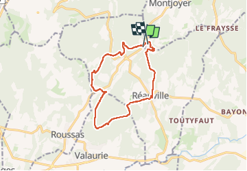
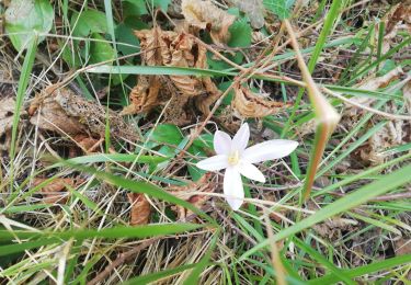
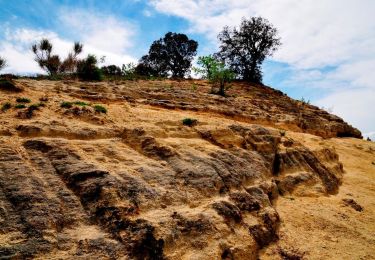
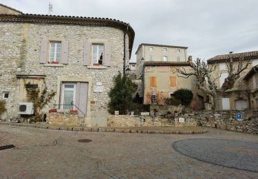
Tour Wandern von 13,8 km verfügbar auf Auvergne-Rhone-Alpen, Drôme, Réauville. Diese Tour wird von alinetpierre vorgeschlagen.
Beschreibung
Très belle randonnée jusqu’à Reauville.
Attention il y avait des travaux en cours de coupes feux, donc de grands chemins de terres.
Ort
Land:
France
Region :
Auvergne-Rhone-Alpen
Abteilung/Provinz :
Drôme
Kommune :
Réauville
Standort:
Unknown
Gehen Sie:(Dec)
Gehen Sie:(UTM)
646372 ; 4924771 (31T) N.
Kommentare
Touren in der Umgebung
![Tour Wandern Roussas - Roussas le Vernet 10km. - Photo](https://media.geolcdn.com/t/375/260/69de5ff3-2ab5-4bbd-b379-bc7253ad9aad.jpg&format=jpg&maxdim=2)
![Wandern Wandern](https://static1.geolcdn.com/sitytour/trail-icons/101.png)
Roussas le Vernet 10km.
Wandern
Schwierig
(1)
Roussas,
Auvergne-Rhone-Alpen,
Drôme,
France
![](/images/other/stat-length.png)
10,3 km | 14,1 km-effort
3h 12min
![](https://static1.geolcdn.com/siteimages/upload/files/16400158638029165_repeat_loop_refresh_sync_direction_icon.png)
Ja
![Tour Wandern Réauville - Reauville Aiguebelle Cascacades 10km - Photo](https://media.geolcdn.com/t/375/260/c8066850-a8b6-4767-b8cc-00eee53525df.jpg&format=jpg&maxdim=2)
![Wandern Wandern](https://static1.geolcdn.com/sitytour/trail-icons/101.png)
Reauville Aiguebelle Cascacades 10km
Wandern
Medium
(1)
Réauville,
Auvergne-Rhone-Alpen,
Drôme,
France
![](/images/other/stat-length.png)
9,3 km | 11,6 km-effort
3h 0min
![](https://static1.geolcdn.com/siteimages/upload/files/16400158638029165_repeat_loop_refresh_sync_direction_icon.png)
Ja
![Tour Wandern Roussas - Roussas Panassas 8 km - Photo](https://media.geolcdn.com/t/375/260/daa93b3b-e486-4ddd-9c21-8f099d0a496e.jpg&format=jpg&maxdim=2)
![Wandern Wandern](https://static1.geolcdn.com/sitytour/trail-icons/101.png)
Roussas Panassas 8 km
Wandern
Einfach
(1)
Roussas,
Auvergne-Rhone-Alpen,
Drôme,
France
![](/images/other/stat-length.png)
7,8 km | 10,6 km-effort
2h 31min
![](https://static1.geolcdn.com/siteimages/upload/files/16400158638029165_repeat_loop_refresh_sync_direction_icon.png)
Ja
![Tour Wandern Allan - allan transclavienne rac - Photo](https://media.geolcdn.com/t/375/260/ext.jpg?maxdim=2&url=https%3A%2F%2Fservices.sitytrail.com%2FGeolivesWS%2FDownloadMedia.ashx%3FTrailID%3D649381%26Media%3Dfix__20161022171755.jpg)
![Wandern Wandern](https://static1.geolcdn.com/sitytour/trail-icons/101.png)
allan transclavienne rac
Wandern
Sehr leicht
(1)
Allan,
Auvergne-Rhone-Alpen,
Drôme,
France
![](/images/other/stat-length.png)
19,1 km | 26 km-effort
5h 11min
![](https://static1.geolcdn.com/siteimages/upload/files/16400158638029165_repeat_loop_refresh_sync_direction_icon.png)
Ja
![Wandern Wandern](https://static1.geolcdn.com/sitytour/trail-icons/101.png)
2022-10-10_11h21m09_tmpWriteApidae_259847_fr
Wandern
Medium
Allan,
Auvergne-Rhone-Alpen,
Drôme,
France
![](/images/other/stat-length.png)
10,7 km | 15,2 km-effort
3h 27min
![](https://static1.geolcdn.com/siteimages/upload/files/16400158638029165_repeat_loop_refresh_sync_direction_icon.png)
Ja
![Tour Wandern La Touche - Citelles hameau et ruisseaux 10km - Photo](https://media.geolcdn.com/t/375/260/ae07cd43-efe5-443c-ada6-328c965bd163.jpg&format=jpg&maxdim=2)
![Wandern Wandern](https://static1.geolcdn.com/sitytour/trail-icons/101.png)
Citelles hameau et ruisseaux 10km
Wandern
Einfach
(2)
La Touche,
Auvergne-Rhone-Alpen,
Drôme,
France
![](/images/other/stat-length.png)
9,6 km | 12,6 km-effort
3h 7min
![](https://static1.geolcdn.com/siteimages/upload/files/16400158638029165_repeat_loop_refresh_sync_direction_icon.png)
Ja
![Tour Wandern Réauville - 2020-02-11_18h44m28_Réauville 7km - Photo](https://media.geolcdn.com/t/375/260/f1284678-f60d-4523-b920-9ecd6b4d9650.jpg&format=jpg&maxdim=2)
![Wandern Wandern](https://static1.geolcdn.com/sitytour/trail-icons/101.png)
2020-02-11_18h44m28_Réauville 7km
Wandern
Medium
Réauville,
Auvergne-Rhone-Alpen,
Drôme,
France
![](/images/other/stat-length.png)
6,9 km | 8,2 km-effort
1h 51min
![](https://static1.geolcdn.com/siteimages/upload/files/16400158638029165_repeat_loop_refresh_sync_direction_icon.png)
Ja
![Tour Wandern Valaurie - Valaurie Aiguebelle 16km - Photo](https://media.geolcdn.com/t/375/260/dd559e93-ad87-4ef8-876d-977a34ec8b7a.jpg&format=jpg&maxdim=2)
![Wandern Wandern](https://static1.geolcdn.com/sitytour/trail-icons/101.png)
Valaurie Aiguebelle 16km
Wandern
Medium
Valaurie,
Auvergne-Rhone-Alpen,
Drôme,
France
![](/images/other/stat-length.png)
16 km | 21 km-effort
5h 0min
![](https://static1.geolcdn.com/siteimages/upload/files/16400158638029165_repeat_loop_refresh_sync_direction_icon.png)
Ja
![Tour sport Allan - SityTrail - Les Villages Perchés. - Photo](https://media.geolcdn.com/t/375/260/ext.jpg?maxdim=2&url=https%3A%2F%2Fsecurestorage.geolives.com%2Fsitytour%2Ftrail-bg%2Fdefault.jpg)
SityTrail - Les Villages Perchés.
sport
Sehr leicht
(1)
Allan,
Auvergne-Rhone-Alpen,
Drôme,
France
![](/images/other/stat-length.png)
19,5 km | 27 km-effort
Unbekannt
![](https://static1.geolcdn.com/siteimages/upload/files/16400158638029165_repeat_loop_refresh_sync_direction_icon.png)
Ja