![](/images/other/stat-length.png)
![Tour Wandern Saint-Sylvestre - st sylvestre 2023 - Photo](https://media.geolcdn.com/t/1900/400/df19fc7c-cc97-4170-8325-723d2008510e.jpg&format=pjpeg&maxdim=2)
st sylvestre 2023
floup6138
Benutzer
![Länge](/images/other/stat-length.png)
Länge
14,7 km
![Maximale Höhe](https://static1.geolcdn.com/siteimages/upload/files/1508320355ic_sort_altitude_max_24dp.png)
Maximale Höhe
624 m
![Positive Höhendifferenz](https://static1.geolcdn.com/siteimages/upload/files/1508320355ic_sort_den_pos_24dp.png)
Positive Höhendifferenz
481 m
![Km-Effort](/images/other/stat-length.png)
Km-Effort
21 km
![Min. Höhe](https://static1.geolcdn.com/siteimages/upload/files/1508320355ic_sort_altitude_min_24dp.png)
Min. Höhe
323 m
![Negative Höhendifferenz](https://static1.geolcdn.com/siteimages/upload/files/1508320355ic_sort_den_neg_24dp.png)
Negative Höhendifferenz
480 m
![Boucle](https://static1.geolcdn.com/siteimages/upload/files/16400158638029165_repeat_loop_refresh_sync_direction_icon.png)
Boucle
Ja
Erstellungsdatum :
2023-03-30 08:20:29.115
Letzte Änderung :
2023-03-30 14:16:52.859
![Wandern](https://static1.geolcdn.com/sitytour/trail-icons/101.png)
4h59
Schwierigkeit : Medium
![Scannen Sie diesen QR-Code, um die Tour in der SityTrail-Anwendung zu öffnen](https://capi.geolives.com/qq0zvz2zws4bq2lad0pu/sitytour/trails/3603101/qr.png?size=200)
Kostenlosegpshiking-Anwendung
Über SityTrail
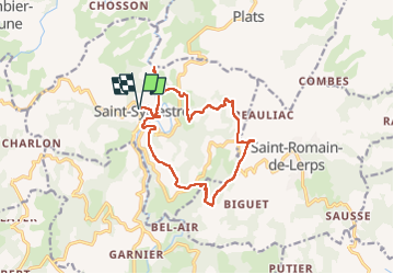
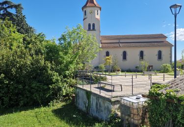
Tour Wandern von 14,7 km verfügbar auf Auvergne-Rhone-Alpen, Ardèche, Saint-Sylvestre. Diese Tour wird von floup6138 vorgeschlagen.
Beschreibung
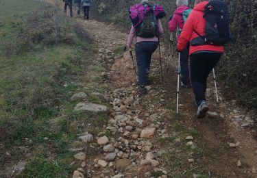
circuit agréable, bien documenté sur d'autres applications.
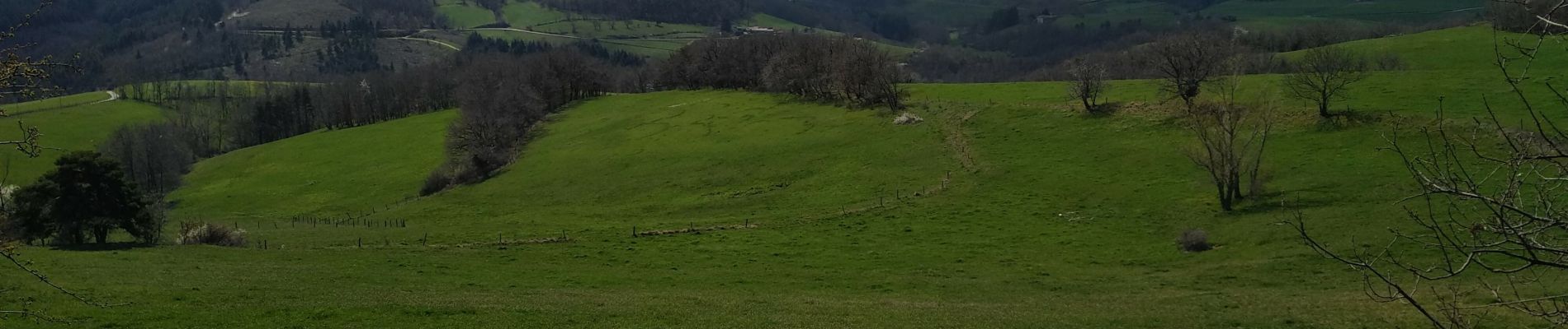
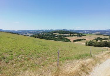
De beaux paysages, chemins agréables en montée, les descentes sont mois faciles car ravinees par la pluie
Ort
Land:
France
Region :
Auvergne-Rhone-Alpen
Abteilung/Provinz :
Ardèche
Kommune :
Saint-Sylvestre
Standort:
Unknown
Gehen Sie:(Dec)
Gehen Sie:(UTM)
637755 ; 4983252 (31T) N.
Kommentare
Touren in der Umgebung
![Tour Wandern Saint-Sylvestre - St Sylvestre Pt Romain 14km - Photo](https://media.geolcdn.com/t/375/260/c56e43c2-f210-46bb-ba2d-0b1abc371b0b.jpg&format=jpg&maxdim=2)
![Wandern Wandern](https://static1.geolcdn.com/sitytour/trail-icons/101.png)
St Sylvestre Pt Romain 14km
Wandern
Medium
Saint-Sylvestre,
Auvergne-Rhone-Alpen,
Ardèche,
France
![](/images/other/stat-length.png)
14,2 km | 21 km-effort
5h 20min
![](https://static1.geolcdn.com/siteimages/upload/files/16400158638029165_repeat_loop_refresh_sync_direction_icon.png)
Ja
![Tour Wandern Saint-Romain-de-Lerps - barbara - Photo](https://media.geolcdn.com/t/375/260/ext.jpg?maxdim=2&url=https%3A%2F%2Fservices.sitytrail.com%2FGeolivesWS%2FDownloadMedia.ashx%3FTrailID%3D892245%26Media%3Dfix__20180123152902.jpg)
![Wandern Wandern](https://static1.geolcdn.com/sitytour/trail-icons/101.png)
barbara
Wandern
Sehr leicht
Saint-Romain-de-Lerps,
Auvergne-Rhone-Alpen,
Ardèche,
France
![](/images/other/stat-length.png)
4,9 km | 6,5 km-effort
1h 25min
![](https://static1.geolcdn.com/siteimages/upload/files/16400158638029165_repeat_loop_refresh_sync_direction_icon.png)
Ja
![Tour sport Saint-Sylvestre - St Sylvestre Croix de Veyrier - Photo](https://media.geolcdn.com/t/375/260/bb9f3cbe-3ab3-44a7-be9d-b9d6bdfb8dd1.jpg&format=jpg&maxdim=2)
St Sylvestre Croix de Veyrier
sport
Sehr leicht
Saint-Sylvestre,
Auvergne-Rhone-Alpen,
Ardèche,
France
![](/images/other/stat-length.png)
14,4 km | 21 km-effort
Unbekannt
![](https://static1.geolcdn.com/siteimages/upload/files/16400158638029165_repeat_loop_refresh_sync_direction_icon.png)
Ja
![Tour Wandern Saint-Romain-de-Lerps - Saint Romain de Lerps - Photo](https://media.geolcdn.com/t/375/260/a044888e-feb7-4477-a8c3-fb7c947b62e8.jpg&format=jpg&maxdim=2)
![Wandern Wandern](https://static1.geolcdn.com/sitytour/trail-icons/101.png)
Saint Romain de Lerps
Wandern
Einfach
Saint-Romain-de-Lerps,
Auvergne-Rhone-Alpen,
Ardèche,
France
![](/images/other/stat-length.png)
4 km | 5,3 km-effort
2h 5min
![](https://static1.geolcdn.com/siteimages/upload/files/16400158638029165_repeat_loop_refresh_sync_direction_icon.png)
Ja
![Tour Reiten Saint-Romain-de-Lerps - SityTrail - J3 Ardèche mardi 6 juin 2023 - Photo](https://media.geolcdn.com/t/375/260/ext.jpg?maxdim=2&url=https%3A%2F%2Fstatic1.geolcdn.com%2Fsiteimages%2Fupload%2Ffiles%2F1524743154cheval.jpg)
![Reiten Reiten](https://static1.geolcdn.com/sitytour/trail-icons/301.png)
SityTrail - J3 Ardèche mardi 6 juin 2023
Reiten
Medium
Saint-Romain-de-Lerps,
Auvergne-Rhone-Alpen,
Ardèche,
France
![](/images/other/stat-length.png)
26 km | 37 km-effort
4h 49min
![](https://static1.geolcdn.com/siteimages/upload/files/16400158638029165_repeat_loop_refresh_sync_direction_icon.png)
Nein
![Tour Wandern Saint-Sylvestre - Saint Sylvestre - Photo](https://media.geolcdn.com/t/375/260/f9027345-0053-4ced-bed6-8170bae80cb9.jpg&format=jpg&maxdim=2)
![Wandern Wandern](https://static1.geolcdn.com/sitytour/trail-icons/101.png)
Saint Sylvestre
Wandern
Medium
(1)
Saint-Sylvestre,
Auvergne-Rhone-Alpen,
Ardèche,
France
![](/images/other/stat-length.png)
15,4 km | 22 km-effort
8h 22min
![](https://static1.geolcdn.com/siteimages/upload/files/16400158638029165_repeat_loop_refresh_sync_direction_icon.png)
Ja
![Tour Wandern Gilhoc-sur-Ormèze - 07 gilhoc sur ormeze - Photo](https://media.geolcdn.com/t/375/260/ext.jpg?maxdim=2&url=https%3A%2F%2Fstatic1.geolcdn.com%2Fsiteimages%2Fupload%2Ffiles%2F1553511878bg_sport_marche.png)
![Wandern Wandern](https://static1.geolcdn.com/sitytour/trail-icons/101.png)
07 gilhoc sur ormeze
Wandern
Medium
Gilhoc-sur-Ormèze,
Auvergne-Rhone-Alpen,
Ardèche,
France
![](/images/other/stat-length.png)
18,4 km | 25 km-effort
4h 57min
![](https://static1.geolcdn.com/siteimages/upload/files/16400158638029165_repeat_loop_refresh_sync_direction_icon.png)
Nein
![Tour Wandern Saint-Sylvestre - Jour un Ardèche - Photo](https://media.geolcdn.com/t/375/260/dea1dcf4-d2f9-43e2-a110-a884ce606258.jpg&format=jpg&maxdim=2)
![Wandern Wandern](https://static1.geolcdn.com/sitytour/trail-icons/101.png)
Jour un Ardèche
Wandern
Einfach
Saint-Sylvestre,
Auvergne-Rhone-Alpen,
Ardèche,
France
![](/images/other/stat-length.png)
14,1 km | 20 km-effort
4h 2min
![](https://static1.geolcdn.com/siteimages/upload/files/16400158638029165_repeat_loop_refresh_sync_direction_icon.png)
Ja
![Tour Wandern Plats - millenium tour - Photo](https://media.geolcdn.com/t/375/260/ext.jpg?maxdim=2&url=https%3A%2F%2Fservices.sitytrail.com%2FGeolivesWS%2FDownloadMedia.ashx%3FTrailID%3D899047%26Media%3Dfix__20180204142427.jpg)
![Wandern Wandern](https://static1.geolcdn.com/sitytour/trail-icons/101.png)
millenium tour
Wandern
Einfach
Plats,
Auvergne-Rhone-Alpen,
Ardèche,
France
![](/images/other/stat-length.png)
3 km | 3,9 km-effort
51min
![](https://static1.geolcdn.com/siteimages/upload/files/16400158638029165_repeat_loop_refresh_sync_direction_icon.png)
Ja