![](/images/other/stat-length.png)
![Tour Zu Fuß Chardonne - Sentier des Narcisses, Le Mont-Pèlerin - Photo](https://media.geolcdn.com/t/1900/400/ext.pjpeg?maxdim=2&url=https%3A%2F%2Fstatic1.geolcdn.com%2Fsiteimages%2Fupload%2Ffiles%2F1545311037marcheuse_200dpi.jpg)
Sentier des Narcisses, Le Mont-Pèlerin
famiski
Benutzer
![Länge](/images/other/stat-length.png)
Länge
8,9 km
![Maximale Höhe](https://static1.geolcdn.com/siteimages/upload/files/1508320355ic_sort_altitude_max_24dp.png)
Maximale Höhe
1068 m
![Positive Höhendifferenz](https://static1.geolcdn.com/siteimages/upload/files/1508320355ic_sort_den_pos_24dp.png)
Positive Höhendifferenz
374 m
![Km-Effort](/images/other/stat-length.png)
Km-Effort
13,8 km
![Min. Höhe](https://static1.geolcdn.com/siteimages/upload/files/1508320355ic_sort_altitude_min_24dp.png)
Min. Höhe
812 m
![Negative Höhendifferenz](https://static1.geolcdn.com/siteimages/upload/files/1508320355ic_sort_den_neg_24dp.png)
Negative Höhendifferenz
367 m
![Boucle](https://static1.geolcdn.com/siteimages/upload/files/16400158638029165_repeat_loop_refresh_sync_direction_icon.png)
Boucle
Ja
Erstellungsdatum :
2023-03-24 09:41:59.65
Letzte Änderung :
2023-03-24 09:42:10.409
![Zu Fuß](https://static1.geolcdn.com/sitytour/trail-icons/100.png)
3h08
Schwierigkeit : Einfach
![Scannen Sie diesen QR-Code, um die Tour in der SityTrail-Anwendung zu öffnen](https://capi.geolives.com/qq0zvz2zws4bq2lad0pu/sitytour/trails/3595801/qr.png?size=200)
Kostenlosegpshiking-Anwendung
Über SityTrail
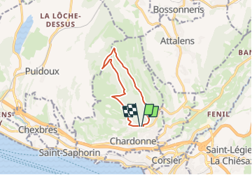
Tour Zu Fuß von 8,9 km verfügbar auf Waadt, District de la Riviera-Pays-d’Enhaut, Chardonne. Diese Tour wird von famiski vorgeschlagen.
Beschreibung
Balisage: panneau de bois sur lequel est gravé un narcisse.
Narcisses en fleurs généralement à la mi-mai.
Ort
Land:
Switzerland
Region :
Waadt
Abteilung/Provinz :
District de la Riviera-Pays-d’Enhaut
Kommune :
Chardonne
Standort:
Unknown
Gehen Sie:(Dec)
Gehen Sie:(UTM)
333552 ; 5149899 (32T) N.
Kommentare
Touren in der Umgebung
![Tour Fahrrad Vevey - Vevey - Nyon - Photo](https://media.geolcdn.com/t/375/260/ext.jpg?maxdim=2&url=https%3A%2F%2Fservices.sitytrail.com%2FGeolivesWS%2FDownloadMedia.ashx%3FTrailID%3D814821%26Media%3Dfix__20170821181246.jpg)
![Fahrrad Fahrrad](https://static1.geolcdn.com/sitytour/trail-icons/200.png)
Vevey - Nyon
Fahrrad
Schwierig
Vevey,
Waadt,
District de la Riviera-Pays-d’Enhaut,
Switzerland
![](/images/other/stat-length.png)
70 km | 82 km-effort
7h 11min
![](https://static1.geolcdn.com/siteimages/upload/files/16400158638029165_repeat_loop_refresh_sync_direction_icon.png)
Nein
![Tour Andere Aktivitäten Chardonne - y10_mont_pellerin - Photo](https://media.geolcdn.com/t/375/260/ext.jpg?maxdim=2&url=https%3A%2F%2Fstatic1.geolcdn.com%2Fsiteimages%2Fupload%2Ffiles%2F1545311037marcheuse_200dpi.jpg)
![Andere Aktivitäten Andere Aktivitäten](https://static1.geolcdn.com/sitytour/trail-icons/900.png)
y10_mont_pellerin
Andere Aktivitäten
Sehr leicht
Chardonne,
Waadt,
District de la Riviera-Pays-d’Enhaut,
Switzerland
![](/images/other/stat-length.png)
9,1 km | 13,4 km-effort
2h 55min
![](https://static1.geolcdn.com/siteimages/upload/files/16400158638029165_repeat_loop_refresh_sync_direction_icon.png)
Ja
![Tour Wandern Saint-Saphorin (Lavaux) - w10_01_lavaux - Photo](https://media.geolcdn.com/t/375/260/ext.jpg?maxdim=2&url=https%3A%2F%2Fstatic1.geolcdn.com%2Fsiteimages%2Fupload%2Ffiles%2F1553511878bg_sport_marche.png)
![Wandern Wandern](https://static1.geolcdn.com/sitytour/trail-icons/101.png)
w10_01_lavaux
Wandern
Sehr leicht
(2)
Saint-Saphorin (Lavaux),
Waadt,
District de Lavaux-Oron,
Switzerland
![](/images/other/stat-length.png)
11,1 km | 15,2 km-effort
3h 52min
![](https://static1.geolcdn.com/siteimages/upload/files/16400158638029165_repeat_loop_refresh_sync_direction_icon.png)
Nein
![Tour Fahrrad La Tour-de-Peilz - Vom Genfersee an den Bodensee - Photo](https://media.geolcdn.com/t/375/260/ext.jpg?maxdim=2&url=https%3A%2F%2Fstatic1.geolcdn.com%2Fsiteimages%2Fupload%2Ffiles%2F1524743154velo.jpg)
![Fahrrad Fahrrad](https://static1.geolcdn.com/sitytour/trail-icons/200.png)
Vom Genfersee an den Bodensee
Fahrrad
Sehr leicht
La Tour-de-Peilz,
Waadt,
District de la Riviera-Pays-d’Enhaut,
Switzerland
![](/images/other/stat-length.png)
302 km | 466 km-effort
123h 6min
![](https://static1.geolcdn.com/siteimages/upload/files/16400158638029165_repeat_loop_refresh_sync_direction_icon.png)
Nein
![Tour Wandern Chexbres - Chexbres: Balade dans le vignoble - Photo](https://media.geolcdn.com/t/375/260/ext.jpg?maxdim=2&url=https%3A%2F%2Fstatic1.geolcdn.com%2Fsiteimages%2Fupload%2Ffiles%2F1553511878bg_sport_marche.png)
![Wandern Wandern](https://static1.geolcdn.com/sitytour/trail-icons/101.png)
Chexbres: Balade dans le vignoble
Wandern
Sehr leicht
Chexbres,
Waadt,
District de Lavaux-Oron,
Switzerland
![](/images/other/stat-length.png)
4,7 km | 6,6 km-effort
Unbekannt
![](https://static1.geolcdn.com/siteimages/upload/files/16400158638029165_repeat_loop_refresh_sync_direction_icon.png)
Nein
![Tour Wandern La Tour-de-Peilz - st_korea_tv1 - Photo](https://media.geolcdn.com/t/375/260/ext.jpg?maxdim=2&url=https%3A%2F%2Fstatic1.geolcdn.com%2Fsiteimages%2Fupload%2Ffiles%2F1553511878bg_sport_marche.png)
![Wandern Wandern](https://static1.geolcdn.com/sitytour/trail-icons/101.png)
st_korea_tv1
Wandern
Sehr leicht
La Tour-de-Peilz,
Waadt,
District de la Riviera-Pays-d’Enhaut,
Switzerland
![](/images/other/stat-length.png)
428 km | 1002 km-effort
29h 5min
![](https://static1.geolcdn.com/siteimages/upload/files/16400158638029165_repeat_loop_refresh_sync_direction_icon.png)
Nein
![Tour Wandern La Tour-de-Peilz - st_ral_08_5 - Photo](https://media.geolcdn.com/t/375/260/ext.jpg?maxdim=2&url=https%3A%2F%2Fstatic1.geolcdn.com%2Fsiteimages%2Fupload%2Ffiles%2F1553511878bg_sport_marche.png)
![Wandern Wandern](https://static1.geolcdn.com/sitytour/trail-icons/101.png)
st_ral_08_5
Wandern
Sehr leicht
La Tour-de-Peilz,
Waadt,
District de la Riviera-Pays-d’Enhaut,
Switzerland
![](/images/other/stat-length.png)
116 km | 154 km-effort
6h 55min
![](https://static1.geolcdn.com/siteimages/upload/files/16400158638029165_repeat_loop_refresh_sync_direction_icon.png)
Nein
![Tour Nordic Walking Chardonne - plein ciel - Photo](https://media.geolcdn.com/t/375/260/d5f8d0a1-ae32-418a-b2ee-bfd684fdbc5b.jpg&format=jpg&maxdim=2)
![Nordic Walking Nordic Walking](https://static1.geolcdn.com/sitytour/trail-icons/102.png)
plein ciel
Nordic Walking
Sehr leicht
Chardonne,
Waadt,
District de la Riviera-Pays-d’Enhaut,
Switzerland
![](/images/other/stat-length.png)
6,2 km | 9,9 km-effort
2h 16min
![](https://static1.geolcdn.com/siteimages/upload/files/16400158638029165_repeat_loop_refresh_sync_direction_icon.png)
Ja
![Tour Zu Fuß Chardonne - Mont-Pèlerin - Photo](https://media.geolcdn.com/t/375/260/ext.jpg?maxdim=2&url=https%3A%2F%2Fstatic1.geolcdn.com%2Fsiteimages%2Fupload%2Ffiles%2F1545311037marcheuse_200dpi.jpg)
![Zu Fuß Zu Fuß](https://static1.geolcdn.com/sitytour/trail-icons/100.png)
Mont-Pèlerin
Zu Fuß
Einfach
Chardonne,
Waadt,
District de la Riviera-Pays-d’Enhaut,
Switzerland
![](/images/other/stat-length.png)
6,3 km | 10,4 km-effort
2h 21min
![](https://static1.geolcdn.com/siteimages/upload/files/16400158638029165_repeat_loop_refresh_sync_direction_icon.png)
Ja