![](/images/other/stat-length.png)
![Tour Mountainbike Croutelle - croutelle boisée - Photo](https://media.geolcdn.com/t/1900/400/ext.pjpeg?maxdim=2&url=https%3A%2F%2Fstatic1.geolcdn.com%2Fsiteimages%2Fupload%2Ffiles%2F1524743154velo.jpg)
croutelle boisée
makiavelplus
Benutzer
![Länge](/images/other/stat-length.png)
![Maximale Höhe](https://static1.geolcdn.com/siteimages/upload/files/1508320355ic_sort_altitude_max_24dp.png)
![Positive Höhendifferenz](https://static1.geolcdn.com/siteimages/upload/files/1508320355ic_sort_den_pos_24dp.png)
![Km-Effort](/images/other/stat-length.png)
![Min. Höhe](https://static1.geolcdn.com/siteimages/upload/files/1508320355ic_sort_altitude_min_24dp.png)
![Negative Höhendifferenz](https://static1.geolcdn.com/siteimages/upload/files/1508320355ic_sort_den_neg_24dp.png)
![Boucle](https://static1.geolcdn.com/siteimages/upload/files/16400158638029165_repeat_loop_refresh_sync_direction_icon.png)
![Mountainbike](https://static1.geolcdn.com/sitytour/trail-icons/202.png)
1h29
Schwierigkeit : Medium
![Scannen Sie diesen QR-Code, um die Tour in der SityTrail-Anwendung zu öffnen](https://capi.geolives.com/qq0zvz2zws4bq2lad0pu/sitytour/trails/359469/qr.png?size=200)
Kostenlosegpshiking-Anwendung
Über SityTrail
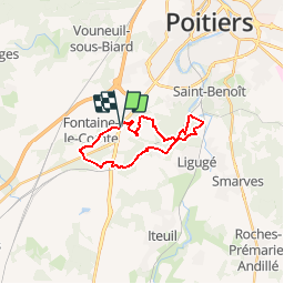
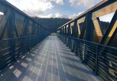
Tour Mountainbike von 18,4 km verfügbar auf Neu-Aquitanien, Vienne, Croutelle. Diese Tour wird von makiavelplus vorgeschlagen.
Beschreibung
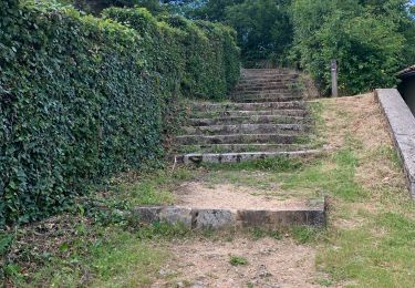
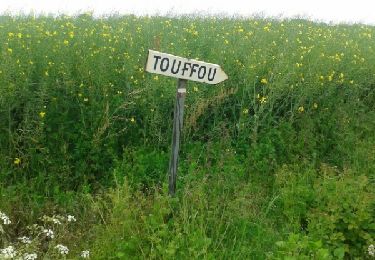
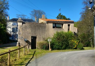
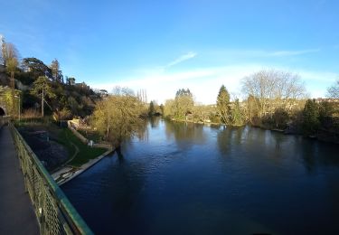
Cette boucle très boisée part de la petite commune du grand poitiers. elle est particulièrement agréable lors des chaudes journées d'été ou à la venu de l'automne. Elle se termine par un apercu de fontaine le compte et de qon abbaye. A noter que cette boucle est aussi intéressante dans un sens que dans l'autre.
Ort
Kommentare
Touren in der Umgebung
![Tour Wandern Poitiers - Poiters St Benoit - Photo](https://media.geolcdn.com/t/375/260/1c049646-5ee2-4f57-842f-e480ac3a3433.jpg&format=jpg&maxdim=2)
![Wandern Wandern](https://static1.geolcdn.com/sitytour/trail-icons/101.png)
Wandern
![](/images/other/stat-length.png)
![](https://static1.geolcdn.com/siteimages/upload/files/16400158638029165_repeat_loop_refresh_sync_direction_icon.png)
![Tour Wandern Ligugé - Voie de Tours Ligugé - Lusignan - Photo](https://media.geolcdn.com/t/375/260/d3559b77-50ce-423d-acff-ed52053e525f.jpg&format=jpg&maxdim=2)
![Wandern Wandern](https://static1.geolcdn.com/sitytour/trail-icons/101.png)
Wandern
![](/images/other/stat-length.png)
![](https://static1.geolcdn.com/siteimages/upload/files/16400158638029165_repeat_loop_refresh_sync_direction_icon.png)
![Tour Wandern Poitiers - SityTrail - Grottes de la Noree - Photo](https://media.geolcdn.com/t/375/260/bad56a70-0545-4e86-894b-a5e906d8d8a0.jpg&format=jpg&maxdim=2)
![Wandern Wandern](https://static1.geolcdn.com/sitytour/trail-icons/101.png)
Wandern
![](/images/other/stat-length.png)
![](https://static1.geolcdn.com/siteimages/upload/files/16400158638029165_repeat_loop_refresh_sync_direction_icon.png)
![Tour Wandern Poitiers - Poitiers intra-muros - Photo](https://media.geolcdn.com/t/375/260/7c65ccee-1131-4d8c-9bc2-4e71491dcdf1.jpg&format=jpg&maxdim=2)
![Wandern Wandern](https://static1.geolcdn.com/sitytour/trail-icons/101.png)
Wandern
![](/images/other/stat-length.png)
![](https://static1.geolcdn.com/siteimages/upload/files/16400158638029165_repeat_loop_refresh_sync_direction_icon.png)
![Tour Wandern Poitiers - JFT YB Etape6 02-05-2014 - Photo](https://media.geolcdn.com/t/375/260/ext.jpg?maxdim=2&url=https%3A%2F%2Fservices.sitytrail.com%2FGeolivesWS%2FDownloadMedia.ashx%3FTrailID%3D272974%26Media%3Dfix__20140502143249.jpg)
![Wandern Wandern](https://static1.geolcdn.com/sitytour/trail-icons/101.png)
Wandern
![](/images/other/stat-length.png)
![](https://static1.geolcdn.com/siteimages/upload/files/16400158638029165_repeat_loop_refresh_sync_direction_icon.png)
![Tour Zu Fuß Saint-Benoît - SityTrail - st Benoit : la médoquerie - Photo](https://media.geolcdn.com/t/375/260/26fffbe3-65e6-460a-bba7-9335380412b6.jpg&format=jpg&maxdim=2)
![Zu Fuß Zu Fuß](https://static1.geolcdn.com/sitytour/trail-icons/100.png)
Zu Fuß
![](/images/other/stat-length.png)
![](https://static1.geolcdn.com/siteimages/upload/files/16400158638029165_repeat_loop_refresh_sync_direction_icon.png)
![Tour Wandern Poitiers - SityTrail - Les Cours / Blossac /Pont Neuf - Photo](https://media.geolcdn.com/t/375/260/1c7cc4e1-06c2-45e0-a1e7-3f4114fb789d.jpg&format=jpg&maxdim=2)
![Wandern Wandern](https://static1.geolcdn.com/sitytour/trail-icons/101.png)
Wandern
![](/images/other/stat-length.png)
![](https://static1.geolcdn.com/siteimages/upload/files/16400158638029165_repeat_loop_refresh_sync_direction_icon.png)
![Tour Wandern Saint-Benoît - SityTrail - st Benoît 9km300 - Photo](https://media.geolcdn.com/t/375/260/92027f27-ce59-4743-a947-d073f64c3aee.jpg&format=jpg&maxdim=2)
![Wandern Wandern](https://static1.geolcdn.com/sitytour/trail-icons/101.png)
Wandern
![](/images/other/stat-length.png)
![](https://static1.geolcdn.com/siteimages/upload/files/16400158638029165_repeat_loop_refresh_sync_direction_icon.png)
![Tour Wandern Béruges - Beruges - Photo](https://media.geolcdn.com/t/375/260/0d75dfd6-5215-4445-8f37-b144f18ffb5c.jpg&format=jpg&maxdim=2)
![Wandern Wandern](https://static1.geolcdn.com/sitytour/trail-icons/101.png)