![](/images/other/stat-length.png)
![Tour Nordic Walking Cayeux-sur-Mer - Le Marais de Cayeux - Photo](https://media.geolcdn.com/t/1900/400/ext.pjpeg?maxdim=2&url=https%3A%2F%2Fstatic1.geolcdn.com%2Fsiteimages%2Fupload%2Ffiles%2F1545311037marcheuse_200dpi.jpg)
Le Marais de Cayeux
roselinemazeyrat
Benutzer
![Länge](/images/other/stat-length.png)
Länge
9 km
![Maximale Höhe](https://static1.geolcdn.com/siteimages/upload/files/1508320355ic_sort_altitude_max_24dp.png)
Maximale Höhe
7 m
![Positive Höhendifferenz](https://static1.geolcdn.com/siteimages/upload/files/1508320355ic_sort_den_pos_24dp.png)
Positive Höhendifferenz
25 m
![Km-Effort](/images/other/stat-length.png)
Km-Effort
9,4 km
![Min. Höhe](https://static1.geolcdn.com/siteimages/upload/files/1508320355ic_sort_altitude_min_24dp.png)
Min. Höhe
1 m
![Negative Höhendifferenz](https://static1.geolcdn.com/siteimages/upload/files/1508320355ic_sort_den_neg_24dp.png)
Negative Höhendifferenz
26 m
![Boucle](https://static1.geolcdn.com/siteimages/upload/files/16400158638029165_repeat_loop_refresh_sync_direction_icon.png)
Boucle
Ja
Erstellungsdatum :
2023-03-19 08:55:25.0
Letzte Änderung :
2023-03-19 14:06:55.832
![Nordic Walking](https://static1.geolcdn.com/sitytour/trail-icons/102.png)
1h44
Schwierigkeit : Sehr leicht
![Scannen Sie diesen QR-Code, um die Tour in der SityTrail-Anwendung zu öffnen](https://capi.geolives.com/qq0zvz2zws4bq2lad0pu/sitytour/trails/3589936/qr.png?size=200)
Kostenlosegpshiking-Anwendung
Über SityTrail
Tour Nordic Walking von 9 km verfügbar auf Nordfrankreich, Somme, Cayeux-sur-Mer. Diese Tour wird von roselinemazeyrat vorgeschlagen.
Beschreibung
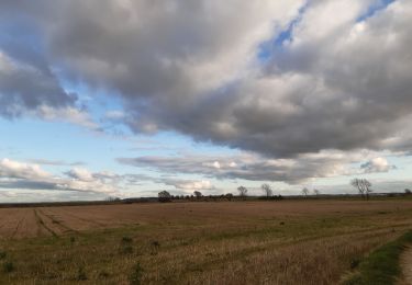
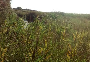
Le hameau du Marais comprend des habitations et des fermes. Les champs ont été gagnés sur la mer. L'usine de galets constitue la richesse industrielle de ce paysage de terres humides.
Ort
Land:
France
Region :
Nordfrankreich
Abteilung/Provinz :
Somme
Kommune :
Cayeux-sur-Mer
Standort:
Unknown
Gehen Sie:(Dec)
Gehen Sie:(UTM)
392720 ; 5558787 (31U) N.
Kommentare
Touren in der Umgebung
![Tour Wandern Cayeux-sur-Mer - Le Hourdel V2 - Photo](https://media.geolcdn.com/t/375/260/ext.jpg?maxdim=2&url=https%3A%2F%2Fservices.sitytrail.com%2FGeolivesWS%2FDownloadMedia.ashx%3FTrailID%3D108609%26Media%3D1517_1.jpg)
![Wandern Wandern](https://static1.geolcdn.com/sitytour/trail-icons/101.png)
Le Hourdel V2
Wandern
Schwierig
(1)
Cayeux-sur-Mer,
Nordfrankreich,
Somme,
France
![](/images/other/stat-length.png)
8 km | 8,4 km-effort
2h 30min
![](https://static1.geolcdn.com/siteimages/upload/files/16400158638029165_repeat_loop_refresh_sync_direction_icon.png)
Ja
![Tour Mountainbike Cayeux-sur-Mer - Cayeux-sur-Mer Cyclisme - Photo](https://media.geolcdn.com/t/375/260/dfc5e36a-a876-4158-8d07-2ca8055ddf3f.jpeg&format=jpg&maxdim=2)
![Mountainbike Mountainbike](https://static1.geolcdn.com/sitytour/trail-icons/202.png)
Cayeux-sur-Mer Cyclisme
Mountainbike
Einfach
Cayeux-sur-Mer,
Nordfrankreich,
Somme,
France
![](/images/other/stat-length.png)
17 km | 17,7 km-effort
1h 13min
![](https://static1.geolcdn.com/siteimages/upload/files/16400158638029165_repeat_loop_refresh_sync_direction_icon.png)
Ja
![Tour Wandern Cayeux-sur-Mer - entre le Hourdel et Cailleux - Photo](https://media.geolcdn.com/t/375/260/b237faa7-5642-4003-8111-9e6140f1adf8.jpg&format=jpg&maxdim=2)
![Wandern Wandern](https://static1.geolcdn.com/sitytour/trail-icons/101.png)
entre le Hourdel et Cailleux
Wandern
Medium
Cayeux-sur-Mer,
Nordfrankreich,
Somme,
France
![](/images/other/stat-length.png)
9,7 km | 10,3 km-effort
2h 28min
![](https://static1.geolcdn.com/siteimages/upload/files/16400158638029165_repeat_loop_refresh_sync_direction_icon.png)
Nein
![Tour Wandern Cayeux-sur-Mer - Crayeux sur mer - Photo](https://media.geolcdn.com/t/375/260/e74086ef-56e3-4ae1-8a72-f13407de6209.jpg&format=jpg&maxdim=2)
![Wandern Wandern](https://static1.geolcdn.com/sitytour/trail-icons/101.png)
Crayeux sur mer
Wandern
Einfach
Cayeux-sur-Mer,
Nordfrankreich,
Somme,
France
![](/images/other/stat-length.png)
4,6 km | 4,8 km-effort
50min
![](https://static1.geolcdn.com/siteimages/upload/files/16400158638029165_repeat_loop_refresh_sync_direction_icon.png)
Ja
![Tour Zu Fuß Cayeux-sur-Mer - Le Hourdel - Photo](https://media.geolcdn.com/t/375/260/e02b6736-5598-4803-9f59-ea4f4aaa2d0c.jpeg&format=jpg&maxdim=2)
![Zu Fuß Zu Fuß](https://static1.geolcdn.com/sitytour/trail-icons/100.png)
Le Hourdel
Zu Fuß
Einfach
Cayeux-sur-Mer,
Nordfrankreich,
Somme,
France
![](/images/other/stat-length.png)
3,3 km | 3,4 km-effort
46min
![](https://static1.geolcdn.com/siteimages/upload/files/16400158638029165_repeat_loop_refresh_sync_direction_icon.png)
Nein
![Tour Wandern Cayeux-sur-Mer - lac de caouaisse . brighton . pointe de hourdel . lac de caouzisse - Photo](https://media.geolcdn.com/t/375/260/a2e73a68-b7d3-4fba-9ddd-e4c4d3c209b6.jpg&format=jpg&maxdim=2)
![Wandern Wandern](https://static1.geolcdn.com/sitytour/trail-icons/101.png)
lac de caouaisse . brighton . pointe de hourdel . lac de caouzisse
Wandern
Einfach
Cayeux-sur-Mer,
Nordfrankreich,
Somme,
France
![](/images/other/stat-length.png)
12,4 km | 13,1 km-effort
4h 28min
![](https://static1.geolcdn.com/siteimages/upload/files/16400158638029165_repeat_loop_refresh_sync_direction_icon.png)
Ja
![Tour Wandern Lanchères - maison de l'oiseau - Photo](https://media.geolcdn.com/t/375/260/ext.jpg?maxdim=2&url=https%3A%2F%2Fservices.sitytrail.com%2FGeolivesWS%2FDownloadMedia.ashx%3FTrailID%3D462656%26Media%3Dfix__20150822180137.jpg)
![Wandern Wandern](https://static1.geolcdn.com/sitytour/trail-icons/101.png)
maison de l'oiseau
Wandern
Sehr leicht
Lanchères,
Nordfrankreich,
Somme,
France
![](/images/other/stat-length.png)
9,8 km | 10,2 km-effort
2h 33min
![](https://static1.geolcdn.com/siteimages/upload/files/16400158638029165_repeat_loop_refresh_sync_direction_icon.png)
Ja
![Tour Wandern Cayeux-sur-Mer - le bourdel - Photo](https://media.geolcdn.com/t/375/260/ext.jpg?maxdim=2&url=https%3A%2F%2Fservices.sitytrail.com%2FGeolivesWS%2FDownloadMedia.ashx%3FTrailID%3D211221%26Media%3D20130808161402.jpg)
![Wandern Wandern](https://static1.geolcdn.com/sitytour/trail-icons/101.png)
le bourdel
Wandern
Sehr leicht
Cayeux-sur-Mer,
Nordfrankreich,
Somme,
France
![](/images/other/stat-length.png)
7,7 km | 8,1 km-effort
1h 56min
![](https://static1.geolcdn.com/siteimages/upload/files/16400158638029165_repeat_loop_refresh_sync_direction_icon.png)
Nein
![Tour Wandern Cayeux-sur-Mer - Le Hourdel - Photo](https://media.geolcdn.com/t/375/260/ext.jpg?maxdim=2&url=https%3A%2F%2Fstatic1.geolcdn.com%2Fsiteimages%2Fupload%2Ffiles%2F1553511878bg_sport_marche.png)
![Wandern Wandern](https://static1.geolcdn.com/sitytour/trail-icons/101.png)
Le Hourdel
Wandern
Medium
(2)
Cayeux-sur-Mer,
Nordfrankreich,
Somme,
France
![](/images/other/stat-length.png)
12,6 km | 13,2 km-effort
Unbekannt
![](https://static1.geolcdn.com/siteimages/upload/files/16400158638029165_repeat_loop_refresh_sync_direction_icon.png)
Ja