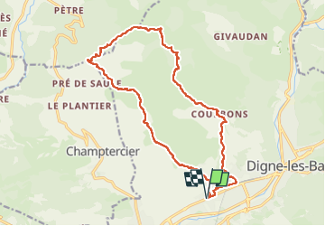
![](/images/other/stat-length.png)
![Tour Wandern Digne-les-Bains - Rando Col de Peipin Courbons - Photo](https://media.geolcdn.com/t/1900/400/0a6325fb-027d-438d-ba66-84054479d73c.jpg&format=pjpeg&maxdim=2)
Rando Col de Peipin Courbons
Marchopier
Benutzer
![Länge](/images/other/stat-length.png)
![Maximale Höhe](https://static1.geolcdn.com/siteimages/upload/files/1508320355ic_sort_altitude_max_24dp.png)
![Positive Höhendifferenz](https://static1.geolcdn.com/siteimages/upload/files/1508320355ic_sort_den_pos_24dp.png)
![Km-Effort](/images/other/stat-length.png)
![Min. Höhe](https://static1.geolcdn.com/siteimages/upload/files/1508320355ic_sort_altitude_min_24dp.png)
![Negative Höhendifferenz](https://static1.geolcdn.com/siteimages/upload/files/1508320355ic_sort_den_neg_24dp.png)
![Boucle](https://static1.geolcdn.com/siteimages/upload/files/16400158638029165_repeat_loop_refresh_sync_direction_icon.png)
![Wandern](https://static1.geolcdn.com/sitytour/trail-icons/101.png)
5h55
Schwierigkeit : Medium
![Scannen Sie diesen QR-Code, um die Tour in der SityTrail-Anwendung zu öffnen](https://capi.geolives.com/qq0zvz2zws4bq2lad0pu/sitytour/trails/3586986/qr.png?size=200)
Kostenlosegpshiking-Anwendung
Über SityTrail
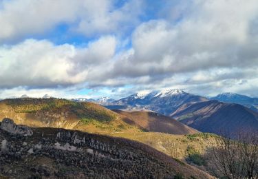
Tour Wandern von 18,5 km verfügbar auf Provence-Alpes-Côte d'Azur, Alpes-de-Haute-Provence, Digne-les-Bains. Diese Tour wird von Marchopier vorgeschlagen.
Beschreibung
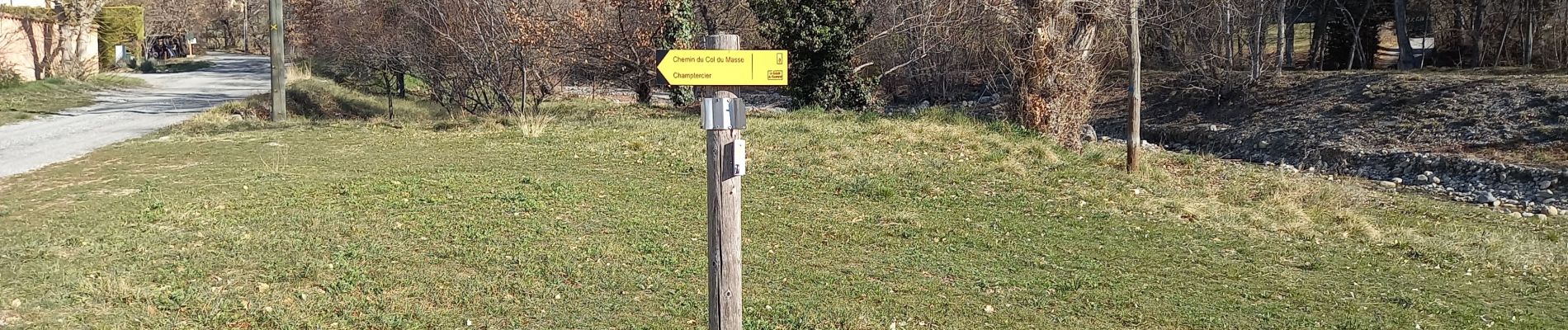
Départ Les Sièyes près de l'école primaire et montée le long du Ravin de Rouveiret, en direction de Champtercier,Chemin du Col du Masse, puis du Col de Peipin, passage du ravin de La Gourre
Le Col de Peipin franchi à 903m d'altitude, la montée continue pourtant sur une piste en direction commune de Thoard et Courbons, ensuite choisi comme direction près de Vachon.
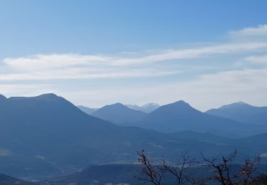
Passage près des pentes de la Colle, point culminant de l'itinéraire 1105m, où un troupeau de moutons venus paitre au soleil, est encadré par six chiens Patou qui donnent de la voix et s'approchent rapidement des promeneurs, nullement effrayés qui leur parlent en réponse à leurs aboiements.
Après des échanges sympathiques les chiens retournent à leurs moutons, et les marcheurs à leurs pas.
Le sentier descend enfin ,bien qu'agrémenté de quelques rampes, passe La Draille, le Ravin de La Buègue, La Chauvine, Suillet, La Martine, et Courbons, joli village perché.
Retour en descente par La Chapelle et les Hautes Sièyes, pour rejoindre le point de départ.
Ort
Kommentare
Touren in der Umgebung
![Tour Wandern Digne-les-Bains - Le Cousson - Photo](https://media.geolcdn.com/t/375/260/5cf44ebe-1058-41b6-9fbf-2454217c16da.jpg&format=jpg&maxdim=2)
![Wandern Wandern](https://static1.geolcdn.com/sitytour/trail-icons/101.png)
Wandern
![](/images/other/stat-length.png)
![](https://static1.geolcdn.com/siteimages/upload/files/16400158638029165_repeat_loop_refresh_sync_direction_icon.png)
![Tour Wandern Digne-les-Bains - Autour de Courbons - Digne les Bains - Photo](https://media.geolcdn.com/t/375/260/ext.jpg?maxdim=2&url=https%3A%2F%2Fservices.sitytrail.com%2FGeolivesWS%2FDownloadMedia.ashx%3FTrailID%3D173256%26Media%3D14871_6.jpg)
![Wandern Wandern](https://static1.geolcdn.com/sitytour/trail-icons/101.png)
Wandern
![](/images/other/stat-length.png)
![](https://static1.geolcdn.com/siteimages/upload/files/16400158638029165_repeat_loop_refresh_sync_direction_icon.png)
![Tour Wandern Digne-les-Bains - courbon la bigue 15kms 900m - Photo](https://media.geolcdn.com/t/375/260/eeca4995-0c3e-4d59-97a2-ea69c1d4e6a1.jpg&format=jpg&maxdim=2)
![Wandern Wandern](https://static1.geolcdn.com/sitytour/trail-icons/101.png)
Wandern
![](/images/other/stat-length.png)
![](https://static1.geolcdn.com/siteimages/upload/files/16400158638029165_repeat_loop_refresh_sync_direction_icon.png)
![Tour Wandern Digne-les-Bains - DIGNE. LA PLATRIERE. RUINES DE GIVAUDAN. CHAPELLE MADELEINE. O L S - Photo](https://media.geolcdn.com/t/375/260/80b6f901-b276-4568-b80a-9babbef2a5d9.jpg&format=jpg&maxdim=2)
![Wandern Wandern](https://static1.geolcdn.com/sitytour/trail-icons/101.png)
Wandern
![](/images/other/stat-length.png)
![](https://static1.geolcdn.com/siteimages/upload/files/16400158638029165_repeat_loop_refresh_sync_direction_icon.png)
![Tour Wandern Aiglun - AIGLUN. Le vieil Aiglun , sommet du Puy o l s - Photo](https://media.geolcdn.com/t/375/260/79f9a8c4-2d87-4650-b00f-e4d73efa9932.jpg&format=jpg&maxdim=2)
![Wandern Wandern](https://static1.geolcdn.com/sitytour/trail-icons/101.png)
Wandern
![](/images/other/stat-length.png)
![](https://static1.geolcdn.com/siteimages/upload/files/16400158638029165_repeat_loop_refresh_sync_direction_icon.png)
![Tour Wandern Digne-les-Bains - COURBONS , Le tour du Rouveyret o - Photo](https://media.geolcdn.com/t/375/260/70308cb0-d54c-40f6-bf71-d74c04a151e9.jpg&format=jpg&maxdim=2)
![Wandern Wandern](https://static1.geolcdn.com/sitytour/trail-icons/101.png)
Wandern
![](/images/other/stat-length.png)
![](https://static1.geolcdn.com/siteimages/upload/files/16400158638029165_repeat_loop_refresh_sync_direction_icon.png)
![Tour Wandern Digne-les-Bains - 65bis-Digne- Cousson N et S- Caramantran- Digne - Photo](https://media.geolcdn.com/t/375/260/ext.jpg?maxdim=2&url=https%3A%2F%2Fstatic1.geolcdn.com%2Fsiteimages%2Fupload%2Ffiles%2F1553511878bg_sport_marche.png)
![Wandern Wandern](https://static1.geolcdn.com/sitytour/trail-icons/101.png)
Wandern
![](/images/other/stat-length.png)
![](https://static1.geolcdn.com/siteimages/upload/files/16400158638029165_repeat_loop_refresh_sync_direction_icon.png)
![Tour Mountainbike Digne-les-Bains - Terres Noires 2011 (50km) - Photo](https://media.geolcdn.com/t/375/260/ext.jpg?maxdim=2&url=https%3A%2F%2Fstatic1.geolcdn.com%2Fsiteimages%2Fupload%2Ffiles%2F1524743154velo.jpg)
![Mountainbike Mountainbike](https://static1.geolcdn.com/sitytour/trail-icons/202.png)
Mountainbike
![](/images/other/stat-length.png)
![](https://static1.geolcdn.com/siteimages/upload/files/16400158638029165_repeat_loop_refresh_sync_direction_icon.png)
![Tour Wandern Digne-les-Bains - De-digne-au-sommet-de-martignon-et-retour-par-courbons - Photo](https://media.geolcdn.com/t/375/260/530c10a1-a2cf-4f9e-b8a2-a7590d62cd26.jpg&format=jpg&maxdim=2)
![Wandern Wandern](https://static1.geolcdn.com/sitytour/trail-icons/101.png)
Wandern
![](/images/other/stat-length.png)
![](https://static1.geolcdn.com/siteimages/upload/files/16400158638029165_repeat_loop_refresh_sync_direction_icon.png)