![](/images/other/stat-length.png)
![Tour Wandern Ferrières - Palogne hamoir Palogne - Photo](https://media.geolcdn.com/t/1900/400/c6d29750-620b-4c93-a218-82e5bccecc69.jpg&format=pjpeg&maxdim=2)
Palogne hamoir Palogne
Thierry Deppe
Benutzer
![Länge](/images/other/stat-length.png)
Länge
16,5 km
![Maximale Höhe](https://static1.geolcdn.com/siteimages/upload/files/1508320355ic_sort_altitude_max_24dp.png)
Maximale Höhe
229 m
![Positive Höhendifferenz](https://static1.geolcdn.com/siteimages/upload/files/1508320355ic_sort_den_pos_24dp.png)
Positive Höhendifferenz
356 m
![Km-Effort](/images/other/stat-length.png)
Km-Effort
21 km
![Min. Höhe](https://static1.geolcdn.com/siteimages/upload/files/1508320355ic_sort_altitude_min_24dp.png)
Min. Höhe
113 m
![Negative Höhendifferenz](https://static1.geolcdn.com/siteimages/upload/files/1508320355ic_sort_den_neg_24dp.png)
Negative Höhendifferenz
372 m
![Boucle](https://static1.geolcdn.com/siteimages/upload/files/16400158638029165_repeat_loop_refresh_sync_direction_icon.png)
Boucle
Nein
Erstellungsdatum :
2023-03-01 11:54:17.0
Letzte Änderung :
2023-03-01 18:57:10.119
![Wandern](https://static1.geolcdn.com/sitytour/trail-icons/101.png)
5h05
Schwierigkeit : Sehr schwierig
![Scannen Sie diesen QR-Code, um die Tour in der SityTrail-Anwendung zu öffnen](https://capi.geolives.com/qq0zvz2zws4bq2lad0pu/sitytour/trails/3569951/qr.png?size=200)
Kostenlosegpshiking-Anwendung
Über SityTrail
Tour Wandern von 16,5 km verfügbar auf Wallonien, Lüttich, Ferrières. Diese Tour wird von Thierry Deppe vorgeschlagen.
Beschreibung
Pas pour les débutants il y a une partie limite escalade mais peut-être évitée il suffit de longer l’eau
Sinon en hauteur superbe point de vue
A faire :-)
Ort
Land:
Belgium
Region :
Wallonien
Abteilung/Provinz :
Lüttich
Kommune :
Ferrières
Standort:
Unknown
Gehen Sie:(Dec)
Gehen Sie:(UTM)
680072 ; 5585781 (31U) N.
Kommentare
Touren in der Umgebung
![Tour Wandern Hamoir - RB-Lg-19_Hamoir - Photo](https://media.geolcdn.com/t/375/260/ext.jpg?maxdim=2&url=https%3A%2F%2Fservices.sitytrail.com%2FGeolivesWS%2FDownloadMedia.ashx%3FTrailID%3D400602%26Media%3Dc0745639-8ded-479e-9345-a8c68cd61e6a.jpg)
![Wandern Wandern](https://static1.geolcdn.com/sitytour/trail-icons/101.png)
RB-Lg-19_Hamoir
Wandern
Sehr schwierig
(6)
Hamoir,
Wallonien,
Lüttich,
Belgium
![](/images/other/stat-length.png)
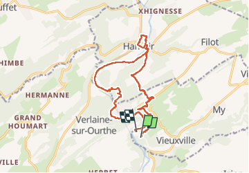
22 km | 28 km-effort
6h 18min
![](https://static1.geolcdn.com/siteimages/upload/files/16400158638029165_repeat_loop_refresh_sync_direction_icon.png)
Ja
![Tour Wandern Durbuy - RB-Lu-01 - Un petit bout de Condroz - Photo](https://media.geolcdn.com/t/375/260/ext.jpg?maxdim=2&url=https%3A%2F%2Fservices.sitytrail.com%2FGeolivesWS%2FDownloadMedia.ashx%3FTrailID%3D179610%26Media%3Dbae66ec4-955f-4295-8f2d-e1b21fcea213.jpg)
![Wandern Wandern](https://static1.geolcdn.com/sitytour/trail-icons/101.png)
RB-Lu-01 - Un petit bout de Condroz
Wandern
Schwierig
(5)
Durbuy,
Wallonien,
Luxemburg,
Belgium
![](/images/other/stat-length.png)
24 km | 30 km-effort
6h 27min
![](https://static1.geolcdn.com/siteimages/upload/files/16400158638029165_repeat_loop_refresh_sync_direction_icon.png)
Ja
![Tour Wandern Durbuy - Balade à Bomal sur Ourthe - Photo](https://media.geolcdn.com/t/375/260/5741dd62-7ff1-40d2-b9aa-0e0aed97da9a.jpg&format=jpg&maxdim=2)
![Wandern Wandern](https://static1.geolcdn.com/sitytour/trail-icons/101.png)
Balade à Bomal sur Ourthe
Wandern
Einfach
(4)
Durbuy,
Wallonien,
Luxemburg,
Belgium
![](/images/other/stat-length.png)
4,4 km | 5,9 km-effort
1h 20min
![](https://static1.geolcdn.com/siteimages/upload/files/16400158638029165_repeat_loop_refresh_sync_direction_icon.png)
Ja
![Tour Wandern Hamoir - HAMOIR (Vallée du Neblon) - Photo](https://media.geolcdn.com/t/375/260/bd133f9f-5595-47e8-88c0-4d09e83d3ba8.jpg&format=jpg&maxdim=2)
![Wandern Wandern](https://static1.geolcdn.com/sitytour/trail-icons/101.png)
HAMOIR (Vallée du Neblon)
Wandern
Medium
(1)
Hamoir,
Wallonien,
Lüttich,
Belgium
![](/images/other/stat-length.png)
8,6 km | 11,4 km-effort
2h 28min
![](https://static1.geolcdn.com/siteimages/upload/files/16400158638029165_repeat_loop_refresh_sync_direction_icon.png)
Ja
![Tour Wandern Ferrières - GG-Lu-15_Sy - Barvaux - Photo](https://media.geolcdn.com/t/375/260/4cf6fb9a-77d5-4c51-bb72-4b6ca6a27202.jpg&format=jpg&maxdim=2)
![Wandern Wandern](https://static1.geolcdn.com/sitytour/trail-icons/101.png)
GG-Lu-15_Sy - Barvaux
Wandern
Sehr schwierig
(1)
Ferrières,
Wallonien,
Lüttich,
Belgium
![](/images/other/stat-length.png)
18,9 km | 26 km-effort
5h 58min
![](https://static1.geolcdn.com/siteimages/upload/files/16400158638029165_repeat_loop_refresh_sync_direction_icon.png)
Nein
![Wandern Wandern](https://static1.geolcdn.com/sitytour/trail-icons/101.png)
GG2-Lu-36_Bomal-Marloie (2021-11-04)
Wandern
Medium
(2)
Durbuy,
Wallonien,
Luxemburg,
Belgium
![](/images/other/stat-length.png)
43 km | 52 km-effort
11h 51min
![](https://static1.geolcdn.com/siteimages/upload/files/16400158638029165_repeat_loop_refresh_sync_direction_icon.png)
Nein
![Tour Wandern Hamoir - Hamoir - Sy - Les Crêtes - Photo](https://media.geolcdn.com/t/375/260/2cd3e10e-e069-4884-9433-cbc8b49962aa.jpg&format=jpg&maxdim=2)
![Wandern Wandern](https://static1.geolcdn.com/sitytour/trail-icons/101.png)
Hamoir - Sy - Les Crêtes
Wandern
Medium
(1)
Hamoir,
Wallonien,
Lüttich,
Belgium
![](/images/other/stat-length.png)
13,1 km | 17,2 km-effort
3h 17min
![](https://static1.geolcdn.com/siteimages/upload/files/16400158638029165_repeat_loop_refresh_sync_direction_icon.png)
Ja
![Tour Wandern Ouffet - ouffet fermes ac + - Photo](https://media.geolcdn.com/t/375/260/fd6ab0a5-da2e-4ec4-9fa1-96c42c21280a.jpg&format=jpg&maxdim=2)
![Wandern Wandern](https://static1.geolcdn.com/sitytour/trail-icons/101.png)
ouffet fermes ac +
Wandern
Medium
(2)
Ouffet,
Wallonien,
Lüttich,
Belgium
![](/images/other/stat-length.png)
8,6 km | 10,7 km-effort
2h 41min
![](https://static1.geolcdn.com/siteimages/upload/files/16400158638029165_repeat_loop_refresh_sync_direction_icon.png)
Ja
![Tour Wandern Durbuy - Sur les dessus de Bomal - Photo](https://media.geolcdn.com/t/375/260/95859345-d2d2-447d-9601-6791094bfa98.jpg&format=jpg&maxdim=2)
![Wandern Wandern](https://static1.geolcdn.com/sitytour/trail-icons/101.png)
Sur les dessus de Bomal
Wandern
Einfach
(3)
Durbuy,
Wallonien,
Luxemburg,
Belgium
![](/images/other/stat-length.png)
6,7 km | 9 km-effort
1h 41min
![](https://static1.geolcdn.com/siteimages/upload/files/16400158638029165_repeat_loop_refresh_sync_direction_icon.png)
Ja