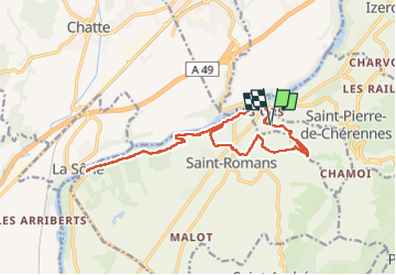
![](/images/other/stat-length.png)
![Tour Nordic Walking Beauvoir-en-Royans - Reconnaissance de Beauvoir-en-Royans à la Sône - Photo](https://media.geolcdn.com/t/1900/400/46a70d8c-b87d-4209-89cd-4426d3fc224d.jpg&format=pjpeg&maxdim=2)
Reconnaissance de Beauvoir-en-Royans à la Sône
Emelle
Benutzer
![Länge](/images/other/stat-length.png)
![Maximale Höhe](https://static1.geolcdn.com/siteimages/upload/files/1508320355ic_sort_altitude_max_24dp.png)
![Positive Höhendifferenz](https://static1.geolcdn.com/siteimages/upload/files/1508320355ic_sort_den_pos_24dp.png)
![Km-Effort](/images/other/stat-length.png)
![Min. Höhe](https://static1.geolcdn.com/siteimages/upload/files/1508320355ic_sort_altitude_min_24dp.png)
![Negative Höhendifferenz](https://static1.geolcdn.com/siteimages/upload/files/1508320355ic_sort_den_neg_24dp.png)
![Boucle](https://static1.geolcdn.com/siteimages/upload/files/16400158638029165_repeat_loop_refresh_sync_direction_icon.png)
![Nordic Walking](https://static1.geolcdn.com/sitytour/trail-icons/102.png)
0m
Schwierigkeit : Medium
![Scannen Sie diesen QR-Code, um die Tour in der SityTrail-Anwendung zu öffnen](https://capi.geolives.com/qq0zvz2zws4bq2lad0pu/sitytour/trails/3556592/qr.png?size=200)
Kostenlosegpshiking-Anwendung
Über SityTrail
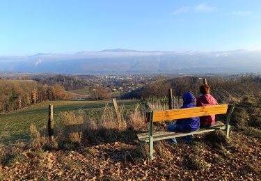
Tour Nordic Walking von 16,9 km verfügbar auf Auvergne-Rhone-Alpen, Isère, Beauvoir-en-Royans. Diese Tour wird von Emelle vorgeschlagen.
Beschreibung
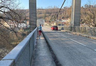
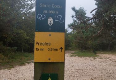
Le retour barrage de Beauvoir au village de Beauvoir-en-Royans n'est pas intéressant. Prévoir de mettre une voiture au barrage de Beauvoir pour éviter cette partie sur la route dangereuse et sans intérêt et pour raccourcir la distance.
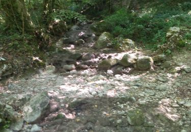
Prudence sur 2 portions assez courtes dans le sentier du Martin Pêcheur, un peu escarpé. Mais en y allant doucement, c'est sans pb.
Ort
Kommentare
Touren in der Umgebung
![Tour Wandern Saint-Pierre-de-Chérennes - 38 st pierre de cherennes faz - Photo](https://media.geolcdn.com/t/375/260/0a570fe9-a063-4011-b0d0-8b0ccdb349b0.jpg&format=jpg&maxdim=2)
![Wandern Wandern](https://static1.geolcdn.com/sitytour/trail-icons/101.png)
Wandern
![](/images/other/stat-length.png)
![](https://static1.geolcdn.com/siteimages/upload/files/16400158638029165_repeat_loop_refresh_sync_direction_icon.png)
![Tour Laufen Beauvoir-en-Royans - Serre Cocu de Beauvoir - Photo](https://media.geolcdn.com/t/375/260/09522623-4bb9-4c1b-9a88-4308da1f7826.jpg&format=jpg&maxdim=2)
![Laufen Laufen](https://static1.geolcdn.com/sitytour/trail-icons/103.png)
Laufen
![](/images/other/stat-length.png)
![](https://static1.geolcdn.com/siteimages/upload/files/16400158638029165_repeat_loop_refresh_sync_direction_icon.png)
![Tour Wandern Beauvoir-en-Royans - Sentier Martin Pêcheur la Roseliere - Photo](https://media.geolcdn.com/t/375/260/ext.jpg?maxdim=2&url=https%3A%2F%2Fservices.sitytrail.com%2FGeolivesWS%2FDownloadMedia.ashx%3FTrailID%3D273764%26Media%3Dfix__20140504144149.jpg)
![Wandern Wandern](https://static1.geolcdn.com/sitytour/trail-icons/101.png)
Wandern
![](/images/other/stat-length.png)
![](https://static1.geolcdn.com/siteimages/upload/files/16400158638029165_repeat_loop_refresh_sync_direction_icon.png)
![Tour Wandern Presles - Presles - rando amandière - (1) - Photo](https://media.geolcdn.com/t/375/260/ext.jpg?maxdim=2&url=https%3A%2F%2Fstatic1.geolcdn.com%2Fsiteimages%2Fupload%2Ffiles%2F1553511878bg_sport_marche.png)
![Wandern Wandern](https://static1.geolcdn.com/sitytour/trail-icons/101.png)
Wandern
![](/images/other/stat-length.png)
![](https://static1.geolcdn.com/siteimages/upload/files/16400158638029165_repeat_loop_refresh_sync_direction_icon.png)
![Tour sport La Sône - La Sône le sentier du martin pêcheur - Photo](https://media.geolcdn.com/t/375/260/08682f10-21b1-4cfe-99a9-176d0da8e24f.jpg&format=jpg&maxdim=2)
sport
![](/images/other/stat-length.png)
![](https://static1.geolcdn.com/siteimages/upload/files/16400158638029165_repeat_loop_refresh_sync_direction_icon.png)
![Tour Wandern Saint-Marcellin - Table d'orientation Chevrières - Photo](https://media.geolcdn.com/t/375/260/5067e4ef-ca84-4b65-9778-ed6b51877c79.jpg&format=jpg&maxdim=2)
![Wandern Wandern](https://static1.geolcdn.com/sitytour/trail-icons/101.png)
Wandern
![](/images/other/stat-length.png)
![](https://static1.geolcdn.com/siteimages/upload/files/16400158638029165_repeat_loop_refresh_sync_direction_icon.png)
![Tour Wandern Saint-André-en-Royans - St André en Royans - Photo](https://media.geolcdn.com/t/375/260/a4444254-b6ff-419c-a9b5-270b3968aa8a.jpg&format=jpg&maxdim=2)
![Wandern Wandern](https://static1.geolcdn.com/sitytour/trail-icons/101.png)
Wandern
![](/images/other/stat-length.png)
![](https://static1.geolcdn.com/siteimages/upload/files/16400158638029165_repeat_loop_refresh_sync_direction_icon.png)
![Tour Mountainbike Presles - Presles - Photo](https://media.geolcdn.com/t/375/260/ad184d0f-c9fc-4f0a-aae3-82c502b3651e.jpg&format=jpg&maxdim=2)
![Mountainbike Mountainbike](https://static1.geolcdn.com/sitytour/trail-icons/202.png)
Mountainbike
![](/images/other/stat-length.png)
![](https://static1.geolcdn.com/siteimages/upload/files/16400158638029165_repeat_loop_refresh_sync_direction_icon.png)
![Tour Wandern Izeron - 38 izeron - Photo](https://media.geolcdn.com/t/375/260/30797a16-7215-428f-aa1d-e291f6048109.jpg&format=jpg&maxdim=2)
![Wandern Wandern](https://static1.geolcdn.com/sitytour/trail-icons/101.png)
Wandern
![](/images/other/stat-length.png)
![](https://static1.geolcdn.com/siteimages/upload/files/16400158638029165_repeat_loop_refresh_sync_direction_icon.png)