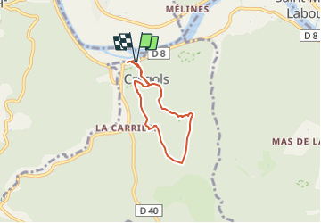
![](/images/other/stat-length.png)
![Tour Wandern Crégols - Le sentier karstique de l'igue de Crégols - Photo](https://media.geolcdn.com/t/1900/400/ext.pjpeg?maxdim=2&url=https%3A%2F%2Fstatic1.geolcdn.com%2Fsiteimages%2Fupload%2Ffiles%2F1553511878bg_sport_marche.png)
Le sentier karstique de l'igue de Crégols
Pierre44
Benutzer
![Länge](/images/other/stat-length.png)
![Maximale Höhe](https://static1.geolcdn.com/siteimages/upload/files/1508320355ic_sort_altitude_max_24dp.png)
![Positive Höhendifferenz](https://static1.geolcdn.com/siteimages/upload/files/1508320355ic_sort_den_pos_24dp.png)
![Km-Effort](/images/other/stat-length.png)
![Min. Höhe](https://static1.geolcdn.com/siteimages/upload/files/1508320355ic_sort_altitude_min_24dp.png)
![Negative Höhendifferenz](https://static1.geolcdn.com/siteimages/upload/files/1508320355ic_sort_den_neg_24dp.png)
![Boucle](https://static1.geolcdn.com/siteimages/upload/files/16400158638029165_repeat_loop_refresh_sync_direction_icon.png)
![Wandern](https://static1.geolcdn.com/sitytour/trail-icons/101.png)
1h37
Schwierigkeit : Medium
![Scannen Sie diesen QR-Code, um die Tour in der SityTrail-Anwendung zu öffnen](https://capi.geolives.com/qq0zvz2zws4bq2lad0pu/sitytour/trails/3554827/qr.png?size=200)
Kostenlosegpshiking-Anwendung
Über SityTrail
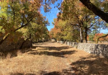
Tour Wandern von 5 km verfügbar auf Okzitanien, Lot, Crégols. Diese Tour wird von Pierre44 vorgeschlagen.
Beschreibung
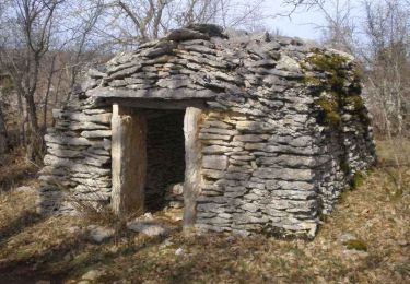
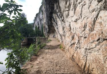
Cette balade vous fera découvrir de belles curiosités géologiques : une ancienne mine de phosphate sous vos pieds, l’impressionnante igue ou encore une résurgence.
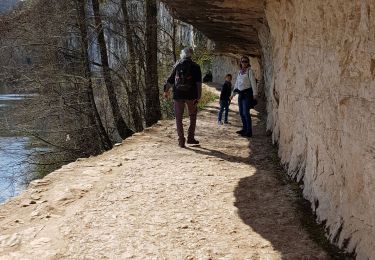
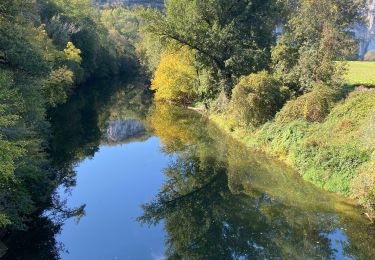
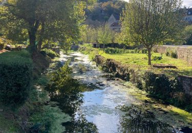
Avec ses nombreuses résurgences, le Lot est le 3ème spot mondial de plongée souterraine. Entre les résurgences du Ressel, de Saint-Sauveur, de Cabouy ou de Crégols, pour ne citer que les plus fréquentées, le choix est vaste. Les plongeurs du monde entier apprécient la clarté des eaux et la diversité des plongées possibles.
- Difficultés particulières : Montée très difficile entre le cimetière et la phosphatière - famille et personnes avec difficultés : accès facile par la variante longue. Attention danger avec des enfants à l'igue car le tour n'est pas sécurisée.
Ort
Kommentare
Touren in der Umgebung
![Tour Wandern Saint-Cirq-Lapopie - Circuit sud de St Cirq Lapopie - Photo](https://media.geolcdn.com/t/375/260/ext.jpg?maxdim=2&url=https%3A%2F%2Fservices.sitytrail.com%2FGeolivesWS%2FDownloadMedia.ashx%3FTrailID%3D136873%26Media%3D13540_3.jpg)
![Wandern Wandern](https://static1.geolcdn.com/sitytour/trail-icons/101.png)
Wandern
![](/images/other/stat-length.png)
![](https://static1.geolcdn.com/siteimages/upload/files/16400158638029165_repeat_loop_refresh_sync_direction_icon.png)
![Tour Wandern Cénevières - Cénevières Calvignac - Causse Lotois - Photo](https://media.geolcdn.com/t/375/260/ext.jpg?maxdim=2&url=https%3A%2F%2Fservices.sitytrail.com%2FGeolivesWS%2FDownloadMedia.ashx%3FTrailID%3D103119%26Media%3D4866_5.jpg)
![Wandern Wandern](https://static1.geolcdn.com/sitytour/trail-icons/101.png)
Wandern
![](/images/other/stat-length.png)
![](https://static1.geolcdn.com/siteimages/upload/files/16400158638029165_repeat_loop_refresh_sync_direction_icon.png)
![Tour Wandern Bouziès - St Cirq Lapopie - Photo](https://media.geolcdn.com/t/375/260/44c160a2-93bf-4659-a751-61d8e3a0eb0e.jpg&format=jpg&maxdim=2)
![Wandern Wandern](https://static1.geolcdn.com/sitytour/trail-icons/101.png)
Wandern
![](/images/other/stat-length.png)
![](https://static1.geolcdn.com/siteimages/upload/files/16400158638029165_repeat_loop_refresh_sync_direction_icon.png)
![Tour Wandern Bouziès - Étape 4 Bouziès Les Mazuts - Photo](https://media.geolcdn.com/t/375/260/0fdee0ad-1a12-42b8-a827-ee8edec2f1aa.jpg&format=jpg&maxdim=2)
![Wandern Wandern](https://static1.geolcdn.com/sitytour/trail-icons/101.png)
Wandern
![](/images/other/stat-length.png)
![](https://static1.geolcdn.com/siteimages/upload/files/16400158638029165_repeat_loop_refresh_sync_direction_icon.png)
![Tour sport Saint-Cirq-Lapopie - 20240422 St Cirq - Vers - Photo](https://media.geolcdn.com/t/375/260/c7c2d083-3a15-4ad8-8255-9f2c2d891e51.jpg&format=jpg&maxdim=2)
sport
![](/images/other/stat-length.png)
![](https://static1.geolcdn.com/siteimages/upload/files/16400158638029165_repeat_loop_refresh_sync_direction_icon.png)
![Tour Wandern Bouziès - Bouzies St Cirq Conduche - Photo](https://media.geolcdn.com/t/375/260/2aaa2ad3-04a4-48d5-bfb5-10fb0e32fe3f.jpg&format=jpg&maxdim=2)
![Wandern Wandern](https://static1.geolcdn.com/sitytour/trail-icons/101.png)
Wandern
![](/images/other/stat-length.png)
![](https://static1.geolcdn.com/siteimages/upload/files/16400158638029165_repeat_loop_refresh_sync_direction_icon.png)
![Tour Wandern Saint-Cirq-Lapopie - Saint Cirq à Cabrerets - Photo](https://media.geolcdn.com/t/375/260/50464022-d44c-4cf4-ba37-ead935c17100.jpg&format=jpg&maxdim=2)
![Wandern Wandern](https://static1.geolcdn.com/sitytour/trail-icons/101.png)
Wandern
![](/images/other/stat-length.png)
![](https://static1.geolcdn.com/siteimages/upload/files/16400158638029165_repeat_loop_refresh_sync_direction_icon.png)
![Tour Wandern Cénevières - Cenevieres rocher de cornus trou madame - Photo](https://media.geolcdn.com/t/375/260/2a98c42f-1712-47f2-9f97-38f3c3492d62.jpg&format=jpg&maxdim=2)
![Wandern Wandern](https://static1.geolcdn.com/sitytour/trail-icons/101.png)
Wandern
![](/images/other/stat-length.png)
![](https://static1.geolcdn.com/siteimages/upload/files/16400158638029165_repeat_loop_refresh_sync_direction_icon.png)
![Tour Wandern Crégols - Concots font d’erbies - Photo](https://media.geolcdn.com/t/375/260/26964f79-784a-459c-a9b3-c1c482f5432a.jpg&format=jpg&maxdim=2)
![Wandern Wandern](https://static1.geolcdn.com/sitytour/trail-icons/101.png)
Wandern
![](/images/other/stat-length.png)
![](https://static1.geolcdn.com/siteimages/upload/files/16400158638029165_repeat_loop_refresh_sync_direction_icon.png)