![](/images/other/stat-length.png)
![Tour Mountainbike La Chapelle-sur-Erdre - la Chapelle Sur Erdre - Photo](https://media.geolcdn.com/t/1900/400/ext.pjpeg?maxdim=2&url=https%3A%2F%2Fstatic1.geolcdn.com%2Fsiteimages%2Fupload%2Ffiles%2F1524743154velo.jpg)
la Chapelle Sur Erdre
Ajax44
Benutzer
![Länge](/images/other/stat-length.png)
Länge
23 km
![Maximale Höhe](https://static1.geolcdn.com/siteimages/upload/files/1508320355ic_sort_altitude_max_24dp.png)
Maximale Höhe
42 m
![Positive Höhendifferenz](https://static1.geolcdn.com/siteimages/upload/files/1508320355ic_sort_den_pos_24dp.png)
Positive Höhendifferenz
267 m
![Km-Effort](/images/other/stat-length.png)
Km-Effort
27 km
![Min. Höhe](https://static1.geolcdn.com/siteimages/upload/files/1508320355ic_sort_altitude_min_24dp.png)
Min. Höhe
3 m
![Negative Höhendifferenz](https://static1.geolcdn.com/siteimages/upload/files/1508320355ic_sort_den_neg_24dp.png)
Negative Höhendifferenz
267 m
![Boucle](https://static1.geolcdn.com/siteimages/upload/files/16400158638029165_repeat_loop_refresh_sync_direction_icon.png)
Boucle
Ja
Erstellungsdatum :
2023-02-15 12:57:41.23
Letzte Änderung :
2023-02-15 15:09:11.223
![Mountainbike](https://static1.geolcdn.com/sitytour/trail-icons/202.png)
1h36
Schwierigkeit : Medium
![Scannen Sie diesen QR-Code, um die Tour in der SityTrail-Anwendung zu öffnen](https://capi.geolives.com/qq0zvz2zws4bq2lad0pu/sitytour/trails/3552955/qr.png?size=200)
Kostenlosegpshiking-Anwendung
Über SityTrail
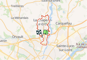
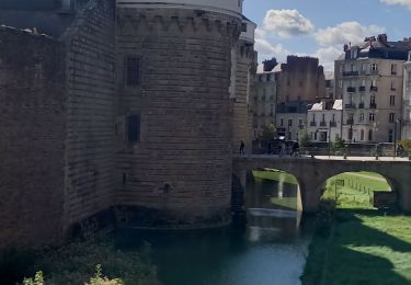
Tour Mountainbike von 23 km verfügbar auf Pays de la Loire, Loire-Atlantique, La Chapelle-sur-Erdre. Diese Tour wird von Ajax44 vorgeschlagen.
Beschreibung
Boucle effectuée en VTTAE
quelques passages sinueux entres les arbres au dessus du Gesvres dans la première partie
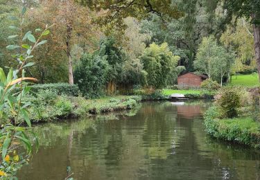
Attention aux promeneurs sur les bords de l'Erdre.
Ort
Land:
France
Region :
Pays de la Loire
Abteilung/Provinz :
Loire-Atlantique
Kommune :
La Chapelle-sur-Erdre
Standort:
Unknown
Gehen Sie:(Dec)
Gehen Sie:(UTM)
609495 ; 5236168 (30T) N.
Kommentare
Touren in der Umgebung
![Tour Zu Fuß La Chapelle-sur-Erdre - grand circuit Erdre/Gesvres - Photo](https://media.geolcdn.com/t/375/260/36b563d8-5e42-407f-af20-6207f8d9317f.jpeg&format=jpg&maxdim=2)
![Zu Fuß Zu Fuß](https://static1.geolcdn.com/sitytour/trail-icons/100.png)
grand circuit Erdre/Gesvres
Zu Fuß
Einfach
La Chapelle-sur-Erdre,
Pays de la Loire,
Loire-Atlantique,
France
![](/images/other/stat-length.png)
4,2 km | 5,2 km-effort
1h 10min
![](https://static1.geolcdn.com/siteimages/upload/files/16400158638029165_repeat_loop_refresh_sync_direction_icon.png)
Nein
![Tour Mountainbike Nantes - Nantes - Photo](https://media.geolcdn.com/t/375/260/ext.jpg?maxdim=2&url=https%3A%2F%2Fstatic1.geolcdn.com%2Fsiteimages%2Fupload%2Ffiles%2F1524743154velo.jpg)
![Mountainbike Mountainbike](https://static1.geolcdn.com/sitytour/trail-icons/202.png)
Nantes
Mountainbike
Medium
(1)
Nantes,
Pays de la Loire,
Loire-Atlantique,
France
![](/images/other/stat-length.png)
32 km | 38 km-effort
2h 6min
![](https://static1.geolcdn.com/siteimages/upload/files/16400158638029165_repeat_loop_refresh_sync_direction_icon.png)
Ja
![Tour Wandern Carquefou - Carquefou les hauts - Photo](https://media.geolcdn.com/t/375/260/ext.jpg?maxdim=2&url=https%3A%2F%2Fstatic1.geolcdn.com%2Fsiteimages%2Fupload%2Ffiles%2F1553511878bg_sport_marche.png)
![Wandern Wandern](https://static1.geolcdn.com/sitytour/trail-icons/101.png)
Carquefou les hauts
Wandern
Einfach
(2)
Carquefou,
Pays de la Loire,
Loire-Atlantique,
France
![](/images/other/stat-length.png)
10,3 km | 11,6 km-effort
2h 34min
![](https://static1.geolcdn.com/siteimages/upload/files/16400158638029165_repeat_loop_refresh_sync_direction_icon.png)
Ja
![Tour Zu Fuß La Chapelle-sur-Erdre - La Source, Le Rupt, l'ancienne voie de chemin de fer - Photo](https://media.geolcdn.com/t/375/260/dd46a926-2019-47c5-9f72-3994a23fb768.jpeg&format=jpg&maxdim=2)
![Zu Fuß Zu Fuß](https://static1.geolcdn.com/sitytour/trail-icons/100.png)
La Source, Le Rupt, l'ancienne voie de chemin de fer
Zu Fuß
Einfach
La Chapelle-sur-Erdre,
Pays de la Loire,
Loire-Atlantique,
France
![](/images/other/stat-length.png)
5,5 km | 6,2 km-effort
1h 25min
![](https://static1.geolcdn.com/siteimages/upload/files/16400158638029165_repeat_loop_refresh_sync_direction_icon.png)
Nein
![Tour Zu Fuß Carquefou - Les Bords de l'Erdre - Photo](https://media.geolcdn.com/t/375/260/c7417e76-e2f6-40cc-bd1f-087623dde044.jpeg&format=jpg&maxdim=2)
![Zu Fuß Zu Fuß](https://static1.geolcdn.com/sitytour/trail-icons/100.png)
Les Bords de l'Erdre
Zu Fuß
Einfach
Carquefou,
Pays de la Loire,
Loire-Atlantique,
France
![](/images/other/stat-length.png)
4,4 km | 5 km-effort
1h 8min
![](https://static1.geolcdn.com/siteimages/upload/files/16400158638029165_repeat_loop_refresh_sync_direction_icon.png)
Nein
![Tour Mountainbike La Chapelle-sur-Erdre - gr3 et vallée du cens - Photo](https://media.geolcdn.com/t/375/260/ext.jpg?maxdim=2&url=https%3A%2F%2Fstatic1.geolcdn.com%2Fsiteimages%2Fupload%2Ffiles%2F1524743154velo.jpg)
![Mountainbike Mountainbike](https://static1.geolcdn.com/sitytour/trail-icons/202.png)
gr3 et vallée du cens
Mountainbike
Einfach
(1)
La Chapelle-sur-Erdre,
Pays de la Loire,
Loire-Atlantique,
France
![](/images/other/stat-length.png)
25 km | 30 km-effort
Unbekannt
![](https://static1.geolcdn.com/siteimages/upload/files/16400158638029165_repeat_loop_refresh_sync_direction_icon.png)
Ja
![Tour Hybrid-Bike Nantes - etape n°1 l'hippodrome université Nantes à Plessis pas Brunet - Photo](https://media.geolcdn.com/t/375/260/f11b735e-088e-4766-b0fc-11001b7156c1.jpg&format=jpg&maxdim=2)
![Hybrid-Bike Hybrid-Bike](https://static1.geolcdn.com/sitytour/trail-icons/203.png)
etape n°1 l'hippodrome université Nantes à Plessis pas Brunet
Hybrid-Bike
Einfach
Nantes,
Pays de la Loire,
Loire-Atlantique,
France
![](/images/other/stat-length.png)
30 km | 33 km-effort
2h 48min
![](https://static1.geolcdn.com/siteimages/upload/files/16400158638029165_repeat_loop_refresh_sync_direction_icon.png)
Nein
![Tour Wandern La Chapelle-sur-Erdre - La Chapelle Erdre Gascherie - Photo](https://media.geolcdn.com/t/375/260/6320ae57-0364-4b55-88d0-a7ec8f53670f.jpg&format=jpg&maxdim=2)
![Wandern Wandern](https://static1.geolcdn.com/sitytour/trail-icons/101.png)
La Chapelle Erdre Gascherie
Wandern
Medium
(1)
La Chapelle-sur-Erdre,
Pays de la Loire,
Loire-Atlantique,
France
![](/images/other/stat-length.png)
9,2 km | 10,1 km-effort
2h 19min
![](https://static1.geolcdn.com/siteimages/upload/files/16400158638029165_repeat_loop_refresh_sync_direction_icon.png)
Ja
![Tour Wandern La Chapelle-sur-Erdre - Nantes - Photo](https://media.geolcdn.com/t/375/260/c71f4b0c-4767-4bda-b5dd-03deb4e6ff77.jpg&format=jpg&maxdim=2)
![Wandern Wandern](https://static1.geolcdn.com/sitytour/trail-icons/101.png)
Nantes
Wandern
Medium
La Chapelle-sur-Erdre,
Pays de la Loire,
Loire-Atlantique,
France
![](/images/other/stat-length.png)
8,3 km | 9,6 km-effort
2h 32min
![](https://static1.geolcdn.com/siteimages/upload/files/16400158638029165_repeat_loop_refresh_sync_direction_icon.png)
Nein