![](/images/other/stat-length.png)
![Tour Wandern Le Saix - Lac de Peyssier - Photo](https://media.geolcdn.com/t/1900/400/8fccd52b-aa7e-4529-9d46-306413d839a3.jpg&format=pjpeg&maxdim=2)
Lac de Peyssier
Marco05
Benutzer GUIDE
![Länge](/images/other/stat-length.png)
Länge
12,8 km
![Maximale Höhe](https://static1.geolcdn.com/siteimages/upload/files/1508320355ic_sort_altitude_max_24dp.png)
Maximale Höhe
1319 m
![Positive Höhendifferenz](https://static1.geolcdn.com/siteimages/upload/files/1508320355ic_sort_den_pos_24dp.png)
Positive Höhendifferenz
513 m
![Km-Effort](/images/other/stat-length.png)
Km-Effort
19,6 km
![Min. Höhe](https://static1.geolcdn.com/siteimages/upload/files/1508320355ic_sort_altitude_min_24dp.png)
Min. Höhe
836 m
![Negative Höhendifferenz](https://static1.geolcdn.com/siteimages/upload/files/1508320355ic_sort_den_neg_24dp.png)
Negative Höhendifferenz
515 m
![Boucle](https://static1.geolcdn.com/siteimages/upload/files/16400158638029165_repeat_loop_refresh_sync_direction_icon.png)
Boucle
Ja
Erstellungsdatum :
2023-02-13 09:42:49.405
Letzte Änderung :
2023-02-17 09:40:34.667
![Wandern](https://static1.geolcdn.com/sitytour/trail-icons/101.png)
4h27
Schwierigkeit : Medium
![Scannen Sie diesen QR-Code, um die Tour in der SityTrail-Anwendung zu öffnen](https://capi.geolives.com/qq0zvz2zws4bq2lad0pu/sitytour/trails/3550192/qr.png?size=200)
Kostenlosegpshiking-Anwendung
Über SityTrail
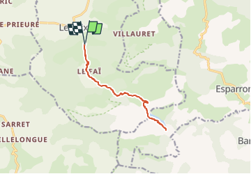
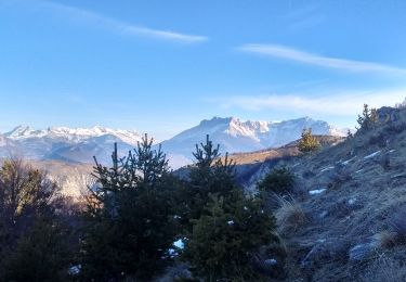
Tour Wandern von 12,8 km verfügbar auf Provence-Alpes-Côte d'Azur, Hochalpen, Le Saix. Diese Tour wird von Marco05 vorgeschlagen.
Beschreibung
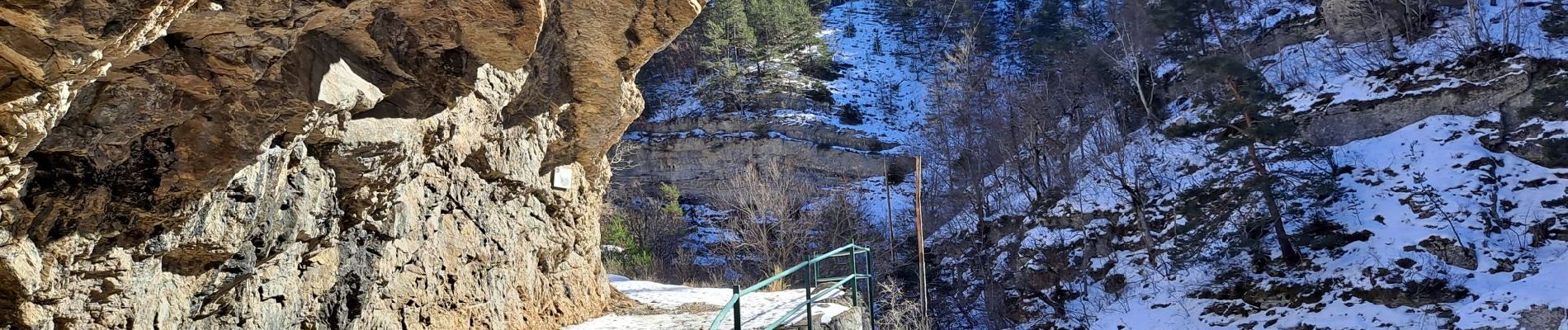
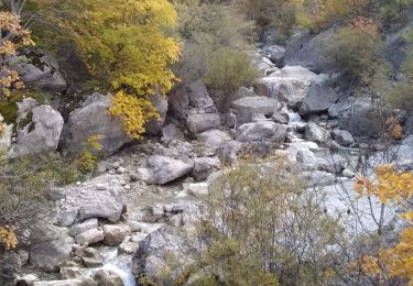
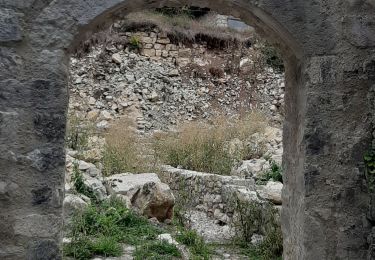
Randonnée facile au départ du village du Saix.
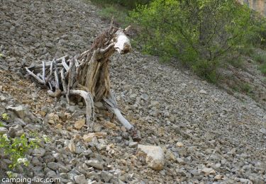
Traverser le village et se garer sur la gauche environ 300m avant le pont qui mène aux gorges de Gouravour.
Ort
Land:
France
Region :
Provence-Alpes-Côte d'Azur
Abteilung/Provinz :
Hochalpen
Kommune :
Le Saix
Standort:
Unknown
Gehen Sie:(Dec)
Gehen Sie:(UTM)
725048 ; 4927875 (31T) N.
Kommentare
Touren in der Umgebung
![Tour Wandern Le Saix - R08 La boucle des cascades jaunes - Photo](https://media.geolcdn.com/t/375/260/f26960bc-bc04-44ac-ad0b-fda399df743b.jpg&format=jpg&maxdim=2)
![Wandern Wandern](https://static1.geolcdn.com/sitytour/trail-icons/101.png)
R08 La boucle des cascades jaunes
Wandern
Sehr leicht
(1)
Le Saix,
Provence-Alpes-Côte d'Azur,
Hochalpen,
France
![](/images/other/stat-length.png)
5,5 km | 10,3 km-effort
2h 10min
![](https://static1.geolcdn.com/siteimages/upload/files/16400158638029165_repeat_loop_refresh_sync_direction_icon.png)
Ja
![Tour Wandern Le Saix - R07 le fai - Photo](https://media.geolcdn.com/t/375/260/ext.jpg?maxdim=2&url=https%3A%2F%2Fservices.sitytrail.com%2FGeolivesWS%2FDownloadMedia.ashx%3FTrailID%3D890860%26Media%3Dd244d5bc-7fc1-4439-9ce7-046c6af92e70.jpg)
![Wandern Wandern](https://static1.geolcdn.com/sitytour/trail-icons/101.png)
R07 le fai
Wandern
Einfach
(4)
Le Saix,
Provence-Alpes-Côte d'Azur,
Hochalpen,
France
![](/images/other/stat-length.png)
5,1 km | 8 km-effort
1h 42min
![](https://static1.geolcdn.com/siteimages/upload/files/16400158638029165_repeat_loop_refresh_sync_direction_icon.png)
Ja
![Tour Wandern Le Saix - Montagne d'Aujour - Photo](https://media.geolcdn.com/t/375/260/2e7276b9-57ac-45f4-9854-1a9eec392654.jpg&format=jpg&maxdim=2)
![Wandern Wandern](https://static1.geolcdn.com/sitytour/trail-icons/101.png)
Montagne d'Aujour
Wandern
Medium
Le Saix,
Provence-Alpes-Côte d'Azur,
Hochalpen,
France
![](/images/other/stat-length.png)
16,4 km | 30 km-effort
5h 33min
![](https://static1.geolcdn.com/siteimages/upload/files/16400158638029165_repeat_loop_refresh_sync_direction_icon.png)
Nein
![Tour Wandern Le Saix - LE SAIX Abbaye de Claussonne n f - Photo](https://media.geolcdn.com/t/375/260/b6678143-8858-4f6e-a21f-ca2b5f31608c.jpg&format=jpg&maxdim=2)
![Wandern Wandern](https://static1.geolcdn.com/sitytour/trail-icons/101.png)
LE SAIX Abbaye de Claussonne n f
Wandern
Medium
Le Saix,
Provence-Alpes-Côte d'Azur,
Hochalpen,
France
![](/images/other/stat-length.png)
12,5 km | 19,9 km-effort
3h 44min
![](https://static1.geolcdn.com/siteimages/upload/files/16400158638029165_repeat_loop_refresh_sync_direction_icon.png)
Ja
![Tour Laufen Le Saix - Trail 10 - La Traversée d'Aujour - Photo](https://media.geolcdn.com/t/375/260/7960e4b2-4014-4f4e-a3b8-18621ca82d72.jpg&format=jpg&maxdim=2)
![Laufen Laufen](https://static1.geolcdn.com/sitytour/trail-icons/103.png)
Trail 10 - La Traversée d'Aujour
Laufen
Schwierig
Le Saix,
Provence-Alpes-Côte d'Azur,
Hochalpen,
France
![](/images/other/stat-length.png)
16,4 km | 31 km-effort
3h 0min
![](https://static1.geolcdn.com/siteimages/upload/files/16400158638029165_repeat_loop_refresh_sync_direction_icon.png)
Ja
![Tour Laufen Saint-Auban-d'Oze - Trail 01 - Le Cirque de Villauret - Photo](https://media.geolcdn.com/t/375/260/11438a15-97de-46a3-a3f1-adac73a9fffe.jpg&format=jpg&maxdim=2)
![Laufen Laufen](https://static1.geolcdn.com/sitytour/trail-icons/103.png)
Trail 01 - Le Cirque de Villauret
Laufen
Schwierig
Saint-Auban-d'Oze,
Provence-Alpes-Côte d'Azur,
Hochalpen,
France
![](/images/other/stat-length.png)
9,6 km | 19,9 km-effort
2h 0min
![](https://static1.geolcdn.com/siteimages/upload/files/16400158638029165_repeat_loop_refresh_sync_direction_icon.png)
Ja
![Tour Wandern Le Saix - R36 - Aujour depuis Clausonne - Photo](https://media.geolcdn.com/t/375/260/ext.jpg?maxdim=2&url=https%3A%2F%2Fservices.sitytrail.com%2FGeolivesWS%2FDownloadMedia.ashx%3FTrailID%3D900901%26Media%3D07eeed14-7ac4-4eb4-8213-2bf0e812ce12.jpg)
![Wandern Wandern](https://static1.geolcdn.com/sitytour/trail-icons/101.png)
R36 - Aujour depuis Clausonne
Wandern
Schwierig
Le Saix,
Provence-Alpes-Côte d'Azur,
Hochalpen,
France
![](/images/other/stat-length.png)
11,9 km | 22 km-effort
4h 27min
![](https://static1.geolcdn.com/siteimages/upload/files/16400158638029165_repeat_loop_refresh_sync_direction_icon.png)
Ja
![Tour Mountainbike Le Saix - VTT19 - Le tour d'Aujour - Photo](https://media.geolcdn.com/t/375/260/ext.jpg?maxdim=2&url=https%3A%2F%2Fservices.sitytrail.com%2FGeolivesWS%2FDownloadMedia.ashx%3FTrailID%3D894015%26Media%3D41e434c1-1cd1-4e1f-8ecf-3f42d1205684.jpg)
![Mountainbike Mountainbike](https://static1.geolcdn.com/sitytour/trail-icons/202.png)
VTT19 - Le tour d'Aujour
Mountainbike
Sehr schwierig
Le Saix,
Provence-Alpes-Côte d'Azur,
Hochalpen,
France
![](/images/other/stat-length.png)
24 km | 40 km-effort
2h 25min
![](https://static1.geolcdn.com/siteimages/upload/files/16400158638029165_repeat_loop_refresh_sync_direction_icon.png)
Ja
![Tour Mountainbike Le Saix - VTT18 - Col de Peyssier - Photo](https://media.geolcdn.com/t/375/260/ext.jpg?maxdim=2&url=https%3A%2F%2Fservices.sitytrail.com%2FGeolivesWS%2FDownloadMedia.ashx%3FTrailID%3D894014%26Media%3D41e434c1-1cd1-4e1f-8ecf-3f42d1205684.jpg)
![Mountainbike Mountainbike](https://static1.geolcdn.com/sitytour/trail-icons/202.png)
VTT18 - Col de Peyssier
Mountainbike
Medium
Le Saix,
Provence-Alpes-Côte d'Azur,
Hochalpen,
France
![](/images/other/stat-length.png)
20 km | 32 km-effort
2h 15min
![](https://static1.geolcdn.com/siteimages/upload/files/16400158638029165_repeat_loop_refresh_sync_direction_icon.png)
Ja