![](/images/other/stat-length.png)
![Tour Wandern Grabels - 2023-02-10_18h09m33_Cirkwi-RANDONNEE_L_OASIS_DES_GARRIGUES - Photo](https://media.geolcdn.com/t/1900/400/ext.pjpeg?maxdim=2&url=https%3A%2F%2Fstatic1.geolcdn.com%2Fsiteimages%2Fupload%2Ffiles%2F1553511878bg_sport_marche.png)
2023-02-10_18h09m33_Cirkwi-RANDONNEE_L_OASIS_DES_GARRIGUES
Levant
Benutzer
![Länge](/images/other/stat-length.png)
![Maximale Höhe](https://static1.geolcdn.com/siteimages/upload/files/1508320355ic_sort_altitude_max_24dp.png)
![Positive Höhendifferenz](https://static1.geolcdn.com/siteimages/upload/files/1508320355ic_sort_den_pos_24dp.png)
![Km-Effort](/images/other/stat-length.png)
![Min. Höhe](https://static1.geolcdn.com/siteimages/upload/files/1508320355ic_sort_altitude_min_24dp.png)
![Negative Höhendifferenz](https://static1.geolcdn.com/siteimages/upload/files/1508320355ic_sort_den_neg_24dp.png)
![Boucle](https://static1.geolcdn.com/siteimages/upload/files/16400158638029165_repeat_loop_refresh_sync_direction_icon.png)
![Wandern](https://static1.geolcdn.com/sitytour/trail-icons/101.png)
3h05
Schwierigkeit : Schwierig
![Scannen Sie diesen QR-Code, um die Tour in der SityTrail-Anwendung zu öffnen](https://capi.geolives.com/qq0zvz2zws4bq2lad0pu/sitytour/trails/3547329/qr.png?size=200)
Kostenlosegpshiking-Anwendung
Über SityTrail
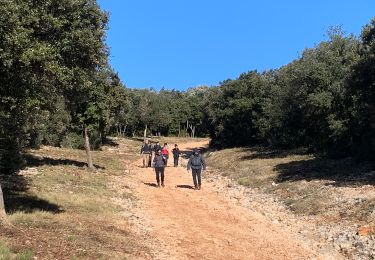
Tour Wandern von 11 km verfügbar auf Okzitanien, Hérault, Grabels. Diese Tour wird von Levant vorgeschlagen.
Beschreibung
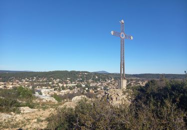
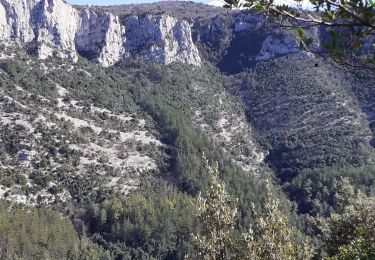
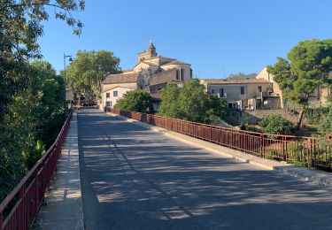
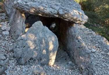
Au départ de ce beau circuit vous découvrirez, le long des rives de la Mosson, la surprenante source de l’Avy. Vous accèderez ensuite au point de vue panoramique de la croix de Guillery. Après la traversée de l’ancienne plaine agricole et viticole, le circuit vous entraînera par le sentier emprunté autrefois par les caravanes de sel jusqu’au sommet des hauts plateaux rocheux partiellement boisés d’où vous pourrez admirer de très beaux panoramas sur les paysages, le Pic Saint-Loup et les massifs environnants. Le nom de Grabels vient du languedocien « gran » (grain de blé) et « bel » (de belle taille), c’est pourquoi une gerbe de blé figure sur le blason de la ville. Dès la Préhistoire, des habitants se regroupent près de la Mosson et cultivent la plaine. Grabels vit en sécurité dans ses remparts encore riches de vestiges.
Ort
Kommentare
Touren in der Umgebung
![Tour Wandern Grabels - Source de l'Avy et tour de Grabels 17.12.23 - Photo](https://media.geolcdn.com/t/375/260/f5395191-c7db-4fbb-a0d5-1ea84961d0f4.jpg&format=jpg&maxdim=2)
![Wandern Wandern](https://static1.geolcdn.com/sitytour/trail-icons/101.png)
Wandern
![](/images/other/stat-length.png)
![](https://static1.geolcdn.com/siteimages/upload/files/16400158638029165_repeat_loop_refresh_sync_direction_icon.png)
![Tour Wandern Grabels - Grabels (source de l'Avy, goule de Laval) - Photo](https://media.geolcdn.com/t/375/260/ext.jpg?maxdim=2&url=https%3A%2F%2Fstatic1.geolcdn.com%2Fsiteimages%2Fupload%2Ffiles%2F1553511878bg_sport_marche.png)
![Wandern Wandern](https://static1.geolcdn.com/sitytour/trail-icons/101.png)
Wandern
![](/images/other/stat-length.png)
![](https://static1.geolcdn.com/siteimages/upload/files/16400158638029165_repeat_loop_refresh_sync_direction_icon.png)
![Tour Wandern Vailhauquès - belair grabels - Photo](https://media.geolcdn.com/t/375/260/ext.jpg?maxdim=2&url=https%3A%2F%2Fstatic1.geolcdn.com%2Fsiteimages%2Fupload%2Ffiles%2F1553511878bg_sport_marche.png)
![Wandern Wandern](https://static1.geolcdn.com/sitytour/trail-icons/101.png)
Wandern
![](/images/other/stat-length.png)
![](https://static1.geolcdn.com/siteimages/upload/files/16400158638029165_repeat_loop_refresh_sync_direction_icon.png)
![Tour Wandern Murles - la garrigue de Murles - Photo](https://media.geolcdn.com/t/375/260/ext.jpg?maxdim=2&url=https%3A%2F%2Fstatic1.geolcdn.com%2Fsiteimages%2Fupload%2Ffiles%2F1553511878bg_sport_marche.png)
![Wandern Wandern](https://static1.geolcdn.com/sitytour/trail-icons/101.png)
Wandern
![](/images/other/stat-length.png)
![](https://static1.geolcdn.com/siteimages/upload/files/16400158638029165_repeat_loop_refresh_sync_direction_icon.png)
![Tour Wandern Grabels - serre grenouillet - Photo](https://media.geolcdn.com/t/375/260/79544ed1-7b3f-4215-a23e-46411ce5a4fb.jpg&format=jpg&maxdim=2)
![Wandern Wandern](https://static1.geolcdn.com/sitytour/trail-icons/101.png)
Wandern
![](/images/other/stat-length.png)
![](https://static1.geolcdn.com/siteimages/upload/files/16400158638029165_repeat_loop_refresh_sync_direction_icon.png)
![Tour Wandern Montpellier - 2023 07 08 chemin du Piémont Pyrénéen (Montpellier -Ballaruc le vieux) - Photo](https://media.geolcdn.com/t/375/260/b0fe6bff-ab5f-4fdb-9615-03ca8a5143ef.jpg&format=jpg&maxdim=2)
![Wandern Wandern](https://static1.geolcdn.com/sitytour/trail-icons/101.png)
Wandern
![](/images/other/stat-length.png)
![](https://static1.geolcdn.com/siteimages/upload/files/16400158638029165_repeat_loop_refresh_sync_direction_icon.png)
![Tour Wandern Murles - Sensei2021 - Photo](https://media.geolcdn.com/t/375/260/2361557c-09ee-4bf6-af3f-849bf7b9ba31.jpg&format=jpg&maxdim=2)
![Wandern Wandern](https://static1.geolcdn.com/sitytour/trail-icons/101.png)
![Tour Wandern Murles - autour de murles 34 - Photo](https://media.geolcdn.com/t/375/260/cea761f6-20ec-43ef-938a-2f599b0e32ed.jpg&format=jpg&maxdim=2)
![Wandern Wandern](https://static1.geolcdn.com/sitytour/trail-icons/101.png)
Wandern
![](/images/other/stat-length.png)
![](https://static1.geolcdn.com/siteimages/upload/files/16400158638029165_repeat_loop_refresh_sync_direction_icon.png)
![Tour Wandern Juvignac - Le 1 mai 18 circuit de 16 kms vers la grotte aux fées - Photo](https://media.geolcdn.com/t/375/260/ext.jpg?maxdim=2&url=https%3A%2F%2Fservices.sitytrail.com%2FGeolivesWS%2FDownloadMedia.ashx%3FTrailID%3D1141391%26Media%3Dfix__20180501114324.jpg)
![Wandern Wandern](https://static1.geolcdn.com/sitytour/trail-icons/101.png)
Wandern
![](/images/other/stat-length.png)
![](https://static1.geolcdn.com/siteimages/upload/files/16400158638029165_repeat_loop_refresh_sync_direction_icon.png)