![](/images/other/stat-length.png)
![Tour Wandern Vaunaveys-la-Rochette - Vaunaveys Crest Vaunaveys - Photo](https://media.geolcdn.com/t/1900/400/ext.pjpeg?maxdim=2&url=https%3A%2F%2Fstatic1.geolcdn.com%2Fsiteimages%2Fupload%2Ffiles%2F1553511878bg_sport_marche.png)
Vaunaveys Crest Vaunaveys
LydiaMich
Benutzer
![Länge](/images/other/stat-length.png)
Länge
13,4 km
![Maximale Höhe](https://static1.geolcdn.com/siteimages/upload/files/1508320355ic_sort_altitude_max_24dp.png)
Maximale Höhe
412 m
![Positive Höhendifferenz](https://static1.geolcdn.com/siteimages/upload/files/1508320355ic_sort_den_pos_24dp.png)
Positive Höhendifferenz
437 m
![Km-Effort](/images/other/stat-length.png)
Km-Effort
19,2 km
![Min. Höhe](https://static1.geolcdn.com/siteimages/upload/files/1508320355ic_sort_altitude_min_24dp.png)
Min. Höhe
193 m
![Negative Höhendifferenz](https://static1.geolcdn.com/siteimages/upload/files/1508320355ic_sort_den_neg_24dp.png)
Negative Höhendifferenz
438 m
![Boucle](https://static1.geolcdn.com/siteimages/upload/files/16400158638029165_repeat_loop_refresh_sync_direction_icon.png)
Boucle
Ja
Erstellungsdatum :
2023-02-09 09:33:18.964
Letzte Änderung :
2023-02-10 09:21:04.795
![Wandern](https://static1.geolcdn.com/sitytour/trail-icons/101.png)
3h37
Schwierigkeit : Einfach
![Scannen Sie diesen QR-Code, um die Tour in der SityTrail-Anwendung zu öffnen](https://capi.geolives.com/qq0zvz2zws4bq2lad0pu/sitytour/trails/3545970/qr.png?size=200)
Kostenlosegpshiking-Anwendung
Über SityTrail
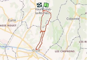
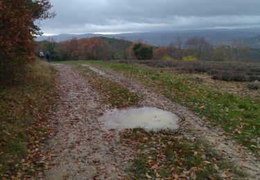
Tour Wandern von 13,4 km verfügbar auf Auvergne-Rhone-Alpen, Drôme, Vaunaveys-la-Rochette. Diese Tour wird von LydiaMich vorgeschlagen.
Beschreibung
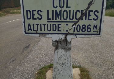
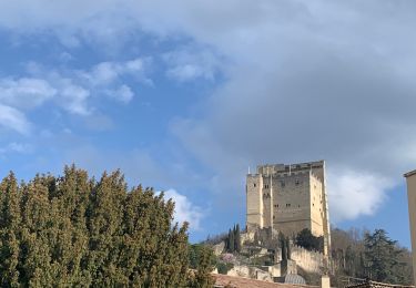
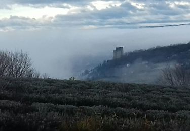
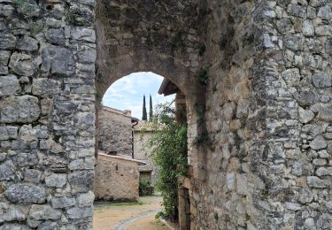
Randonnée entre Vaunaveys et Crest en boucle bien sympathique. On peut en profiter pour une petite visite du vieux Crest au passage avant de monter à sa tour.
Ort
Land:
France
Region :
Auvergne-Rhone-Alpen
Abteilung/Provinz :
Drôme
Kommune :
Vaunaveys-la-Rochette
Standort:
Unknown
Gehen Sie:(Dec)
Gehen Sie:(UTM)
660882 ; 4959309 (31T) N.
Kommentare
Touren in der Umgebung
![Tour Wandern Crest - Crest / Col de Bessot - Photo](https://media.geolcdn.com/t/375/260/ext.jpg?maxdim=2&url=https%3A%2F%2Fservices.sitytrail.com%2FGeolivesWS%2FDownloadMedia.ashx%3FTrailID%3D497687%26Media%3Dfix__20151127133911.jpg)
![Wandern Wandern](https://static1.geolcdn.com/sitytour/trail-icons/101.png)
Crest / Col de Bessot
Wandern
Medium
(2)
Crest,
Auvergne-Rhone-Alpen,
Drôme,
France
![](/images/other/stat-length.png)
19,5 km | 28 km-effort
5h 52min
![](https://static1.geolcdn.com/siteimages/upload/files/16400158638029165_repeat_loop_refresh_sync_direction_icon.png)
Ja
![Tour Wandern Crest - Crest à VAUNAVEY - Photo](https://media.geolcdn.com/t/375/260/ext.jpg?maxdim=2&url=https%3A%2F%2Fmedia.geolcdn.com%2Ff%2F286137c0-d121-4814-8720-e6aa22e27ac9.jpg)
![Wandern Wandern](https://static1.geolcdn.com/sitytour/trail-icons/101.png)
Crest à VAUNAVEY
Wandern
Sehr leicht
Crest,
Auvergne-Rhone-Alpen,
Drôme,
France
![](/images/other/stat-length.png)
9,2 km | 11,5 km-effort
1h 58min
![](https://static1.geolcdn.com/siteimages/upload/files/16400158638029165_repeat_loop_refresh_sync_direction_icon.png)
Nein
![Tour Wandern Crest - Crest les crêtes - Photo](https://media.geolcdn.com/t/375/260/ext.jpg?maxdim=2&url=https%3A%2F%2Fmedia.geolcdn.com%2Ff%2Fd13859cb-c499-4b0f-86ce-a9a52bdb88e9.jpg)
![Wandern Wandern](https://static1.geolcdn.com/sitytour/trail-icons/101.png)
Crest les crêtes
Wandern
Einfach
Crest,
Auvergne-Rhone-Alpen,
Drôme,
France
![](/images/other/stat-length.png)
7,4 km | 10,7 km-effort
2h 0min
![](https://static1.geolcdn.com/siteimages/upload/files/16400158638029165_repeat_loop_refresh_sync_direction_icon.png)
Ja
![Tour Wandern Crest - Crest - Photo](https://media.geolcdn.com/t/375/260/ext.jpg?maxdim=2&url=https%3A%2F%2Fmedia.geolcdn.com%2Ff%2Fe9e06745-c5f4-4002-b953-5ca3b3c4882f.jpg)
![Wandern Wandern](https://static1.geolcdn.com/sitytour/trail-icons/101.png)
![Tour Wandern Crest - CREST Festi'Rando - Photo](https://media.geolcdn.com/t/375/260/ext.jpg?maxdim=2&url=https%3A%2F%2Fmedia.geolcdn.com%2Ff%2F04ef8fcb-55be-4ead-ad42-a1399ab562d5.jpg)
![Wandern Wandern](https://static1.geolcdn.com/sitytour/trail-icons/101.png)
CREST Festi'Rando
Wandern
Schwierig
Crest,
Auvergne-Rhone-Alpen,
Drôme,
France
![](/images/other/stat-length.png)
13,6 km | 18,9 km-effort
5h 44min
![](https://static1.geolcdn.com/siteimages/upload/files/16400158638029165_repeat_loop_refresh_sync_direction_icon.png)
Ja
![Tour Rennrad Crest - j3 Crest limouche vauna vaunaveys 01.07.23 - Photo](https://media.geolcdn.com/t/375/260/ext.jpg?maxdim=2&url=https%3A%2F%2Fmedia.geolcdn.com%2Ff%2Ff1e7664d-d94c-4a24-8662-9bd9acc5deea.jpg)
![Rennrad Rennrad](https://static1.geolcdn.com/sitytour/trail-icons/201.png)
j3 Crest limouche vauna vaunaveys 01.07.23
Rennrad
Medium
Crest,
Auvergne-Rhone-Alpen,
Drôme,
France
![](/images/other/stat-length.png)
66 km | 85 km-effort
5h 58min
![](https://static1.geolcdn.com/siteimages/upload/files/16400158638029165_repeat_loop_refresh_sync_direction_icon.png)
Nein
![Tour Wandern Crest - Grane jour 3 - Photo](https://media.geolcdn.com/t/375/260/ext.jpg?maxdim=2&url=https%3A%2F%2Fmedia.geolcdn.com%2Ff%2F5b484320-de27-4f60-bb8c-674d65323a10.jpg)
![Wandern Wandern](https://static1.geolcdn.com/sitytour/trail-icons/101.png)
Grane jour 3
Wandern
Medium
Crest,
Auvergne-Rhone-Alpen,
Drôme,
France
![](/images/other/stat-length.png)
12,7 km | 18,6 km-effort
3h 31min
![](https://static1.geolcdn.com/siteimages/upload/files/16400158638029165_repeat_loop_refresh_sync_direction_icon.png)
Ja
![Tour Wandern Gigors-et-Lozeron - la rivière.gigors.lozeron. - Photo](https://media.geolcdn.com/t/375/260/ext.jpg?maxdim=2&url=https%3A%2F%2Fmedia.geolcdn.com%2Ff%2Ff090ab4f-913b-4011-8841-56286b93115f.jpg)
![Wandern Wandern](https://static1.geolcdn.com/sitytour/trail-icons/101.png)
la rivière.gigors.lozeron.
Wandern
Einfach
Gigors-et-Lozeron,
Auvergne-Rhone-Alpen,
Drôme,
France
![](/images/other/stat-length.png)
18,1 km | 29 km-effort
7h 2min
![](https://static1.geolcdn.com/siteimages/upload/files/16400158638029165_repeat_loop_refresh_sync_direction_icon.png)
Ja
![Tour Wandern Ourches - le tour de Chalamet - Photo](https://media.geolcdn.com/t/375/260/ext.jpg?maxdim=2&url=https%3A%2F%2Fmedia.geolcdn.com%2Ff%2F07c76494-0572-46c7-8461-f26545d726ef.jpg)
![Wandern Wandern](https://static1.geolcdn.com/sitytour/trail-icons/101.png)
le tour de Chalamet
Wandern
Medium
(1)
Ourches,
Auvergne-Rhone-Alpen,
Drôme,
France
![](/images/other/stat-length.png)
10,7 km | 18,7 km-effort
3h 51min
![](https://static1.geolcdn.com/siteimages/upload/files/16400158638029165_repeat_loop_refresh_sync_direction_icon.png)
Ja