![](/images/other/stat-length.png)
![Tour Wandern Neuville-sur-Saône - A_NEUVILLE 69250 Autour du ruisseau des Torrières - Photo](https://media.geolcdn.com/t/1900/400/ext.pjpeg?maxdim=2&url=https%3A%2F%2Fstatic1.geolcdn.com%2Fsiteimages%2Fupload%2Ffiles%2F1553511878bg_sport_marche.png)
A_NEUVILLE 69250 Autour du ruisseau des Torrières
ANDREJAC
Benutzer
![Länge](/images/other/stat-length.png)
Länge
10 km
![Maximale Höhe](https://static1.geolcdn.com/siteimages/upload/files/1508320355ic_sort_altitude_max_24dp.png)
Maximale Höhe
299 m
![Positive Höhendifferenz](https://static1.geolcdn.com/siteimages/upload/files/1508320355ic_sort_den_pos_24dp.png)
Positive Höhendifferenz
204 m
![Km-Effort](/images/other/stat-length.png)
Km-Effort
12,8 km
![Min. Höhe](https://static1.geolcdn.com/siteimages/upload/files/1508320355ic_sort_altitude_min_24dp.png)
Min. Höhe
169 m
![Negative Höhendifferenz](https://static1.geolcdn.com/siteimages/upload/files/1508320355ic_sort_den_neg_24dp.png)
Negative Höhendifferenz
203 m
![Boucle](https://static1.geolcdn.com/siteimages/upload/files/16400158638029165_repeat_loop_refresh_sync_direction_icon.png)
Boucle
Ja
Erstellungsdatum :
2014-12-10 00:00:00.0
Letzte Änderung :
2014-12-10 00:00:00.0
![Wandern](https://static1.geolcdn.com/sitytour/trail-icons/101.png)
3h00
Schwierigkeit : Einfach
![Scannen Sie diesen QR-Code, um die Tour in der SityTrail-Anwendung zu öffnen](https://capi.geolives.com/qq0zvz2zws4bq2lad0pu/sitytour/trails/354506/qr.png?size=200)
Kostenlosegpshiking-Anwendung
Über SityTrail
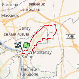
Tour Wandern von 10 km verfügbar auf Auvergne-Rhone-Alpen, Métropole de Lyon, Neuville-sur-Saône. Diese Tour wird von ANDREJAC vorgeschlagen.
Beschreibung
Départ et retour : parking rive gauche, en amont du pont.
Vers le Parc, en passant près de l'Etang, la Bascule, les Brettets, les Vernes Champ Blanchet, vers le Monteiller, le quai.
Ort
Land:
France
Region :
Auvergne-Rhone-Alpen
Abteilung/Provinz :
Métropole de Lyon
Kommune :
Neuville-sur-Saône
Standort:
Unknown
Gehen Sie:(Dec)
Gehen Sie:(UTM)
642620 ; 5082131 (31T) N.
Kommentare
Touren in der Umgebung
![Tour Wandern Couzon-au-Mont-d'Or - Tour de Couzon par les crêtes - Photo](https://media.geolcdn.com/t/375/260/ext.jpg?maxdim=2&url=https%3A%2F%2Fservices.sitytrail.com%2FGeolivesWS%2FDownloadMedia.ashx%3FTrailID%3D626228%26Media%3D20160904183041.jpg)
![Wandern Wandern](https://static1.geolcdn.com/sitytour/trail-icons/101.png)
Tour de Couzon par les crêtes
Wandern
Schwierig
(2)
Couzon-au-Mont-d'Or,
Auvergne-Rhone-Alpen,
Métropole de Lyon,
France
![](/images/other/stat-length.png)
6,5 km | 10,7 km-effort
2h 5min
![](https://static1.geolcdn.com/siteimages/upload/files/16400158638029165_repeat_loop_refresh_sync_direction_icon.png)
Ja
![Tour Reiten Saint-Germain-au-Mont-d'Or - J LIB SGGlaMontagnard Long - Photo](https://media.geolcdn.com/t/375/260/ext.jpg?maxdim=2&url=https%3A%2F%2Fstatic1.geolcdn.com%2Fsiteimages%2Fupload%2Ffiles%2F1524743154cheval.jpg)
![Reiten Reiten](https://static1.geolcdn.com/sitytour/trail-icons/301.png)
J LIB SGGlaMontagnard Long
Reiten
Schwierig
(1)
Saint-Germain-au-Mont-d'Or,
Auvergne-Rhone-Alpen,
Métropole de Lyon,
France
![](/images/other/stat-length.png)
27 km | 39 km-effort
5h 8min
![](https://static1.geolcdn.com/siteimages/upload/files/16400158638029165_repeat_loop_refresh_sync_direction_icon.png)
Ja
![Tour Reiten Saint-Germain-au-Mont-d'Or - A supp test DD1-3 Mare tab Chair Tab Lav - Photo](https://media.geolcdn.com/t/375/260/ext.jpg?maxdim=2&url=https%3A%2F%2Fstatic1.geolcdn.com%2Fsiteimages%2Fupload%2Ffiles%2F1524743154cheval.jpg)
![Reiten Reiten](https://static1.geolcdn.com/sitytour/trail-icons/301.png)
A supp test DD1-3 Mare tab Chair Tab Lav
Reiten
Einfach
(2)
Saint-Germain-au-Mont-d'Or,
Auvergne-Rhone-Alpen,
Métropole de Lyon,
France
![](/images/other/stat-length.png)
12,3 km | 19 km-effort
2h 30min
![](https://static1.geolcdn.com/siteimages/upload/files/16400158638029165_repeat_loop_refresh_sync_direction_icon.png)
Ja
![Tour Reiten Saint-Germain-au-Mont-d'Or - J LIB SGChaGlaMontagnard 27k 40kf - Photo](https://media.geolcdn.com/t/375/260/ext.jpg?maxdim=2&url=https%3A%2F%2Fstatic1.geolcdn.com%2Fsiteimages%2Fupload%2Ffiles%2F1524743154cheval.jpg)
![Reiten Reiten](https://static1.geolcdn.com/sitytour/trail-icons/301.png)
J LIB SGChaGlaMontagnard 27k 40kf
Reiten
Schwierig
(1)
Saint-Germain-au-Mont-d'Or,
Auvergne-Rhone-Alpen,
Métropole de Lyon,
France
![](/images/other/stat-length.png)
27 km | 40 km-effort
5h 13min
![](https://static1.geolcdn.com/siteimages/upload/files/16400158638029165_repeat_loop_refresh_sync_direction_icon.png)
Ja
![Tour Reiten Saint-Germain-au-Mont-d'Or - J LIB SGChaGlaMontagnard Long - Photo](https://media.geolcdn.com/t/375/260/ext.jpg?maxdim=2&url=https%3A%2F%2Fstatic1.geolcdn.com%2Fsiteimages%2Fupload%2Ffiles%2F1524743154cheval.jpg)
![Reiten Reiten](https://static1.geolcdn.com/sitytour/trail-icons/301.png)
J LIB SGChaGlaMontagnard Long
Reiten
Sehr schwierig
(1)
Saint-Germain-au-Mont-d'Or,
Auvergne-Rhone-Alpen,
Métropole de Lyon,
France
![](/images/other/stat-length.png)
29 km | 43 km-effort
5h 39min
![](https://static1.geolcdn.com/siteimages/upload/files/16400158638029165_repeat_loop_refresh_sync_direction_icon.png)
Ja
![Tour Reiten Saint-Germain-au-Mont-d'Or - DC 4 SGMO Mar Vel Vigne Table 14km 21kf - Photo](https://media.geolcdn.com/t/375/260/ext.jpg?maxdim=2&url=https%3A%2F%2Fstatic1.geolcdn.com%2Fsiteimages%2Fupload%2Ffiles%2F1524743154cheval.jpg)
![Reiten Reiten](https://static1.geolcdn.com/sitytour/trail-icons/301.png)
DC 4 SGMO Mar Vel Vigne Table 14km 21kf
Reiten
Medium
(1)
Saint-Germain-au-Mont-d'Or,
Auvergne-Rhone-Alpen,
Métropole de Lyon,
France
![](/images/other/stat-length.png)
13,7 km | 21 km-effort
2h 43min
![](https://static1.geolcdn.com/siteimages/upload/files/16400158638029165_repeat_loop_refresh_sync_direction_icon.png)
Ja
![Tour Reiten Saint-Germain-au-Mont-d'Or - DD1-3 Mare tab Chair Tab Lav - Photo](https://media.geolcdn.com/t/375/260/ext.jpg?maxdim=2&url=https%3A%2F%2Fstatic1.geolcdn.com%2Fsiteimages%2Fupload%2Ffiles%2F1524743154cheval.jpg)
![Reiten Reiten](https://static1.geolcdn.com/sitytour/trail-icons/301.png)
DD1-3 Mare tab Chair Tab Lav
Reiten
Einfach
(2)
Saint-Germain-au-Mont-d'Or,
Auvergne-Rhone-Alpen,
Métropole de Lyon,
France
![](/images/other/stat-length.png)
12,3 km | 19,1 km-effort
2h 30min
![](https://static1.geolcdn.com/siteimages/upload/files/16400158638029165_repeat_loop_refresh_sync_direction_icon.png)
Ja
![Tour Zu Fuß Saint-Germain-au-Mont-d'Or - Grand Tour des Monts d'Or - Photo](https://media.geolcdn.com/t/375/260/50138287-4896-425f-9aee-b9551d3b8f65.jpeg&format=jpg&maxdim=2)
![Zu Fuß Zu Fuß](https://static1.geolcdn.com/sitytour/trail-icons/100.png)
Grand Tour des Monts d'Or
Zu Fuß
Medium
Saint-Germain-au-Mont-d'Or,
Auvergne-Rhone-Alpen,
Métropole de Lyon,
France
![](/images/other/stat-length.png)
17,4 km | 27 km-effort
6h 9min
![](https://static1.geolcdn.com/siteimages/upload/files/16400158638029165_repeat_loop_refresh_sync_direction_icon.png)
Nein
![Tour Reiten Saint-Germain-au-Mont-d'Or - SGMO - Journée Lucenay Anse Trevoux - Photo](https://media.geolcdn.com/t/375/260/ext.jpg?maxdim=2&url=https%3A%2F%2Fstatic1.geolcdn.com%2Fsiteimages%2Fupload%2Ffiles%2F1524743154cheval.jpg)
![Reiten Reiten](https://static1.geolcdn.com/sitytour/trail-icons/301.png)
SGMO - Journée Lucenay Anse Trevoux
Reiten
Schwierig
(3)
Saint-Germain-au-Mont-d'Or,
Auvergne-Rhone-Alpen,
Métropole de Lyon,
France
![](/images/other/stat-length.png)
35 km | 39 km-effort
5h 8min
![](https://static1.geolcdn.com/siteimages/upload/files/16400158638029165_repeat_loop_refresh_sync_direction_icon.png)
Ja