![](/images/other/stat-length.png)
![Tour Zu Fuß Hastingues - SityTrail - HASTINGUES PATRIMOINE G4 - Photo](https://media.geolcdn.com/t/1900/400/ext.pjpeg?maxdim=2&url=https%3A%2F%2Fstatic1.geolcdn.com%2Fsiteimages%2Fupload%2Ffiles%2F1545311037marcheuse_200dpi.jpg)
SityTrail - HASTINGUES PATRIMOINE G4
marmotte65
Benutzer GUIDE
![Länge](/images/other/stat-length.png)
Länge
8,8 km
![Maximale Höhe](https://static1.geolcdn.com/siteimages/upload/files/1508320355ic_sort_altitude_max_24dp.png)
Maximale Höhe
85 m
![Positive Höhendifferenz](https://static1.geolcdn.com/siteimages/upload/files/1508320355ic_sort_den_pos_24dp.png)
Positive Höhendifferenz
166 m
![Km-Effort](/images/other/stat-length.png)
Km-Effort
11 km
![Min. Höhe](https://static1.geolcdn.com/siteimages/upload/files/1508320355ic_sort_altitude_min_24dp.png)
Min. Höhe
-1 m
![Negative Höhendifferenz](https://static1.geolcdn.com/siteimages/upload/files/1508320355ic_sort_den_neg_24dp.png)
Negative Höhendifferenz
166 m
![Boucle](https://static1.geolcdn.com/siteimages/upload/files/16400158638029165_repeat_loop_refresh_sync_direction_icon.png)
Boucle
Ja
Erstellungsdatum :
2023-02-08 13:04:16.849
Letzte Änderung :
2023-02-08 13:04:59.614
![Zu Fuß](https://static1.geolcdn.com/sitytour/trail-icons/100.png)
2h29
Schwierigkeit : Einfach
![Scannen Sie diesen QR-Code, um die Tour in der SityTrail-Anwendung zu öffnen](https://capi.geolives.com/qq0zvz2zws4bq2lad0pu/sitytour/trails/3544796/qr.png?size=200)
Kostenlosegpshiking-Anwendung
Über SityTrail
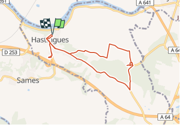
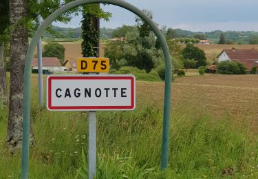
Tour Zu Fuß von 8,8 km verfügbar auf Neu-Aquitanien, Landes, Hastingues. Diese Tour wird von marmotte65 vorgeschlagen.
Beschreibung
Randonnée agréable avec une forte valeur rajoutée culturelle.
Evocation du Chemin de St Jacques
Abbaye d'Arthous
Village medieval de Hastingues et son histoire intimement lié à la guerre de 100 ans.
Ort
Land:
France
Region :
Neu-Aquitanien
Abteilung/Provinz :
Landes
Kommune :
Hastingues
Standort:
Unknown
Gehen Sie:(Dec)
Gehen Sie:(UTM)
649576 ; 4821847 (30T) N.
Kommentare
Touren in der Umgebung
![Tour Wandern Hastingues - hastingues G4fait - Photo](https://media.geolcdn.com/t/375/260/23522374-026d-4316-8aa7-712b16875391.jpg&format=jpg&maxdim=2)
![Wandern Wandern](https://static1.geolcdn.com/sitytour/trail-icons/101.png)
hastingues G4fait
Wandern
Sehr leicht
Hastingues,
Neu-Aquitanien,
Landes,
France
![](/images/other/stat-length.png)
9,1 km | 11,3 km-effort
5h 6min
![](https://static1.geolcdn.com/siteimages/upload/files/16400158638029165_repeat_loop_refresh_sync_direction_icon.png)
Ja
![Tour Wandern Port-de-Lanne - Chateau du Bec de Gave et bords de l'Adour - Photo](https://media.geolcdn.com/t/375/260/03a2f356-79c3-4c84-be44-f7a7d9932e64.jpg&format=jpg&maxdim=2)
![Wandern Wandern](https://static1.geolcdn.com/sitytour/trail-icons/101.png)
Chateau du Bec de Gave et bords de l'Adour
Wandern
Medium
(1)
Port-de-Lanne,
Neu-Aquitanien,
Landes,
France
![](/images/other/stat-length.png)
9,6 km | 10,7 km-effort
2h 26min
![](https://static1.geolcdn.com/siteimages/upload/files/16400158638029165_repeat_loop_refresh_sync_direction_icon.png)
Ja
![Tour Pferd Sames - Sames - La Bastide Clairence - Photo](https://media.geolcdn.com/t/375/260/ext.jpg?maxdim=2&url=https%3A%2F%2Fservices.sitytrail.com%2FGeolivesWS%2FDownloadMedia.ashx%3FTrailID%3D129725%26Media%3D13269_1.jpg)
![Pferd Pferd](https://static1.geolcdn.com/sitytour/trail-icons/300.png)
Sames - La Bastide Clairence
Pferd
Schwierig
Sames,
Neu-Aquitanien,
Pyrenäen-Atlantik,
France
![](/images/other/stat-length.png)
30 km | 36 km-effort
5h 0min
![](https://static1.geolcdn.com/siteimages/upload/files/16400158638029165_repeat_loop_refresh_sync_direction_icon.png)
Nein
![Tour Wandern Hastingues - Long de la Bidouze - Photo](https://media.geolcdn.com/t/375/260/c2a9643c-d279-46e6-aab5-105df74ace43.jpg&format=jpg&maxdim=2)
![Wandern Wandern](https://static1.geolcdn.com/sitytour/trail-icons/101.png)
Long de la Bidouze
Wandern
Einfach
Hastingues,
Neu-Aquitanien,
Landes,
France
![](/images/other/stat-length.png)
4 km | 4,4 km-effort
1h 4min
![](https://static1.geolcdn.com/siteimages/upload/files/16400158638029165_repeat_loop_refresh_sync_direction_icon.png)
Ja
![Tour Radtourismus Oeyregave - Peyrehorade - C17 - Balade en Pays d'Orthe - Circuit long - 65 Km - Photo](https://media.geolcdn.com/t/375/260/ext.jpg?maxdim=2&url=https%3A%2F%2Fstatic1.geolcdn.com%2Fsiteimages%2Fupload%2Ffiles%2F1524743154velo.jpg)
![Radtourismus Radtourismus](https://static1.geolcdn.com/sitytour/trail-icons/204.png)
Peyrehorade - C17 - Balade en Pays d'Orthe - Circuit long - 65 Km
Radtourismus
Sehr schwierig
Oeyregave,
Neu-Aquitanien,
Landes,
France
![](/images/other/stat-length.png)
65 km | 76 km-effort
3h 38min
![](https://static1.geolcdn.com/siteimages/upload/files/16400158638029165_repeat_loop_refresh_sync_direction_icon.png)
Ja
![Tour Zu Fuß Hastingues - HASTINGUES PATRIMOINE G4 - Photo](https://media.geolcdn.com/t/375/260/ext.jpg?maxdim=2&url=https%3A%2F%2Fstatic1.geolcdn.com%2Fsiteimages%2Fupload%2Ffiles%2F1545311037marcheuse_200dpi.jpg)
![Zu Fuß Zu Fuß](https://static1.geolcdn.com/sitytour/trail-icons/100.png)
HASTINGUES PATRIMOINE G4
Zu Fuß
Einfach
Hastingues,
Neu-Aquitanien,
Landes,
France
![](/images/other/stat-length.png)
8,8 km | 11 km-effort
Unbekannt
![](https://static1.geolcdn.com/siteimages/upload/files/16400158638029165_repeat_loop_refresh_sync_direction_icon.png)
Ja
![Tour Mountainbike Orthevielle - parcours vert Peyrehorade - Photo](https://media.geolcdn.com/t/375/260/667e6da0-8813-4080-995a-a9e72ba17a06.jpg&format=jpg&maxdim=2)
![Mountainbike Mountainbike](https://static1.geolcdn.com/sitytour/trail-icons/202.png)
parcours vert Peyrehorade
Mountainbike
Medium
Orthevielle,
Neu-Aquitanien,
Landes,
France
![](/images/other/stat-length.png)
58 km | 66 km-effort
2h 43min
![](https://static1.geolcdn.com/siteimages/upload/files/16400158638029165_repeat_loop_refresh_sync_direction_icon.png)
Ja
![Tour Wandern Guiche - Guiche - Photo](https://media.geolcdn.com/t/375/260/ext.jpg?maxdim=2&url=https%3A%2F%2Fstatic1.geolcdn.com%2Fsiteimages%2Fupload%2Ffiles%2F1553511878bg_sport_marche.png)
![Wandern Wandern](https://static1.geolcdn.com/sitytour/trail-icons/101.png)
Guiche
Wandern
Sehr leicht
Guiche,
Neu-Aquitanien,
Pyrenäen-Atlantik,
France
![](/images/other/stat-length.png)
11 km | 13,6 km-effort
2h 57min
![](https://static1.geolcdn.com/siteimages/upload/files/16400158638029165_repeat_loop_refresh_sync_direction_icon.png)
Ja
![Tour Wandern Hastingues - Trace G4 Hastingues Guy - Photo](https://media.geolcdn.com/t/375/260/ext.jpg?maxdim=2&url=https%3A%2F%2Fstatic1.geolcdn.com%2Fsiteimages%2Fupload%2Ffiles%2F1553511878bg_sport_marche.png)
![Wandern Wandern](https://static1.geolcdn.com/sitytour/trail-icons/101.png)
Trace G4 Hastingues Guy
Wandern
Hastingues,
Neu-Aquitanien,
Landes,
France
![](/images/other/stat-length.png)
10,6 km | 13 km-effort
5h 13min
![](https://static1.geolcdn.com/siteimages/upload/files/16400158638029165_repeat_loop_refresh_sync_direction_icon.png)
Ja