![](/images/other/stat-length.png)
![Tour Wandern Briis-sous-Forges - 2023-02-08 Rando Briis-sous-Forges - Photo](https://media.geolcdn.com/t/1900/400/ext.pjpeg?maxdim=2&url=https%3A%2F%2Fstatic1.geolcdn.com%2Fsiteimages%2Fupload%2Ffiles%2F1553511878bg_sport_marche.png)
2023-02-08 Rando Briis-sous-Forges
jchezlemas
Benutzer
![Länge](/images/other/stat-length.png)
Länge
11,9 km
![Maximale Höhe](https://static1.geolcdn.com/siteimages/upload/files/1508320355ic_sort_altitude_max_24dp.png)
Maximale Höhe
166 m
![Positive Höhendifferenz](https://static1.geolcdn.com/siteimages/upload/files/1508320355ic_sort_den_pos_24dp.png)
Positive Höhendifferenz
162 m
![Km-Effort](/images/other/stat-length.png)
Km-Effort
14,1 km
![Min. Höhe](https://static1.geolcdn.com/siteimages/upload/files/1508320355ic_sort_altitude_min_24dp.png)
Min. Höhe
88 m
![Negative Höhendifferenz](https://static1.geolcdn.com/siteimages/upload/files/1508320355ic_sort_den_neg_24dp.png)
Negative Höhendifferenz
164 m
![Boucle](https://static1.geolcdn.com/siteimages/upload/files/16400158638029165_repeat_loop_refresh_sync_direction_icon.png)
Boucle
Ja
Erstellungsdatum :
2023-02-08 08:04:36.038
Letzte Änderung :
2023-02-08 18:05:30.732
![Wandern](https://static1.geolcdn.com/sitytour/trail-icons/101.png)
2h42
Schwierigkeit : Einfach
![Scannen Sie diesen QR-Code, um die Tour in der SityTrail-Anwendung zu öffnen](https://capi.geolives.com/qq0zvz2zws4bq2lad0pu/sitytour/trails/3544675/qr.png?size=200)
Kostenlosegpshiking-Anwendung
Über SityTrail
Tour Wandern von 11,9 km verfügbar auf Île-de-France, Essonne, Briis-sous-Forges. Diese Tour wird von jchezlemas vorgeschlagen.
Beschreibung
Rando de Martine et Alain Gauthier
Office de Tourisme de l'Arpajonnais
https://www.ot-coeuressonne.fr/
Ort
Land:
France
Region :
Île-de-France
Abteilung/Provinz :
Essonne
Kommune :
Briis-sous-Forges
Standort:
Unknown
Gehen Sie:(Dec)
Gehen Sie:(UTM)
435776 ; 5386606 (31U) N.
Kommentare
Touren in der Umgebung
![Tour Wandern Limours - Essonne_Tour_des_Fermes_de_la_Prédecelle - Photo](https://media.geolcdn.com/t/375/260/2a39169f-a228-484c-b261-d2ccff03535e.jpg&format=jpg&maxdim=2)
![Wandern Wandern](https://static1.geolcdn.com/sitytour/trail-icons/101.png)
Essonne_Tour_des_Fermes_de_la_Prédecelle
Wandern
Sehr leicht
(1)
Limours,
Île-de-France,
Essonne,
France
![](/images/other/stat-length.png)
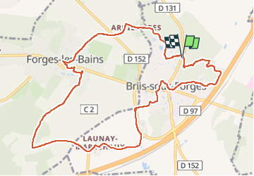
12,9 km | 14,3 km-effort
3h 43min
![](https://static1.geolcdn.com/siteimages/upload/files/16400158638029165_repeat_loop_refresh_sync_direction_icon.png)
Ja
![Tour Wandern Limours - Essonne_RD_Limours=>Viaduc=>Prédecelle=>Chaumusson - Photo](https://media.geolcdn.com/t/375/260/c60124a9-cca7-4dae-90e5-561e58250ffa.jpg&format=jpg&maxdim=2)
![Wandern Wandern](https://static1.geolcdn.com/sitytour/trail-icons/101.png)
Essonne_RD_Limours=>Viaduc=>Prédecelle=>Chaumusson
Wandern
Einfach
(1)
Limours,
Île-de-France,
Essonne,
France
![](/images/other/stat-length.png)
7,4 km | 8,4 km-effort
2h 30min
![](https://static1.geolcdn.com/siteimages/upload/files/16400158638029165_repeat_loop_refresh_sync_direction_icon.png)
Ja
![Tour Wandern Limours - 20210319_Limours_Viaduc_Prédecelle_Amont - Photo](https://media.geolcdn.com/t/375/260/c60124a9-cca7-4dae-90e5-561e58250ffa.jpg&format=jpg&maxdim=2)
![Wandern Wandern](https://static1.geolcdn.com/sitytour/trail-icons/101.png)
20210319_Limours_Viaduc_Prédecelle_Amont
Wandern
Einfach
(1)
Limours,
Île-de-France,
Essonne,
France
![](/images/other/stat-length.png)
8,7 km | 9,9 km-effort
2h 30min
![](https://static1.geolcdn.com/siteimages/upload/files/16400158638029165_repeat_loop_refresh_sync_direction_icon.png)
Ja
![Tour Wandern Courson-Monteloup - Boucle au départ du château de Courson - Photo](https://media.geolcdn.com/t/375/260/ed11977b-20c0-4900-b0e3-aa6abed829d7.jpg&format=jpg&maxdim=2)
![Wandern Wandern](https://static1.geolcdn.com/sitytour/trail-icons/101.png)
Boucle au départ du château de Courson
Wandern
Einfach
Courson-Monteloup,
Île-de-France,
Essonne,
France
![](/images/other/stat-length.png)
23 km | 27 km-effort
5h 7min
![](https://static1.geolcdn.com/siteimages/upload/files/16400158638029165_repeat_loop_refresh_sync_direction_icon.png)
Ja
![Tour Wandern Bruyères-le-Châtel - Boucle Fontenay les Briis - Photo](https://media.geolcdn.com/t/375/260/1dc49ccb-e1a4-4ed8-a4eb-f6cdbc4809ff.jpg&format=jpg&maxdim=2)
![Wandern Wandern](https://static1.geolcdn.com/sitytour/trail-icons/101.png)
Boucle Fontenay les Briis
Wandern
Sehr leicht
Bruyères-le-Châtel,
Île-de-France,
Essonne,
France
![](/images/other/stat-length.png)
22 km | 26 km-effort
5h 4min
![](https://static1.geolcdn.com/siteimages/upload/files/16400158638029165_repeat_loop_refresh_sync_direction_icon.png)
Ja
![Tour Mountainbike Limours - St Arnoult 33km-2h30 - Photo](https://media.geolcdn.com/t/375/260/ext.jpg?maxdim=2&url=https%3A%2F%2Fstatic1.geolcdn.com%2Fsiteimages%2Fupload%2Ffiles%2F1524743154velo.jpg)
![Mountainbike Mountainbike](https://static1.geolcdn.com/sitytour/trail-icons/202.png)
St Arnoult 33km-2h30
Mountainbike
Schwierig
(1)
Limours,
Île-de-France,
Essonne,
France
![](/images/other/stat-length.png)
34 km | 39 km-effort
2h 33min
![](https://static1.geolcdn.com/siteimages/upload/files/16400158638029165_repeat_loop_refresh_sync_direction_icon.png)
Ja
![Tour Mountainbike Fontenay-lès-Briis - Soucy / Le Marais - Photo](https://media.geolcdn.com/t/375/260/ext.jpg?maxdim=2&url=https%3A%2F%2Fstatic1.geolcdn.com%2Fsiteimages%2Fupload%2Ffiles%2F1524743154velo.jpg)
![Mountainbike Mountainbike](https://static1.geolcdn.com/sitytour/trail-icons/202.png)
Soucy / Le Marais
Mountainbike
Medium
(2)
Fontenay-lès-Briis,
Île-de-France,
Essonne,
France
![](/images/other/stat-length.png)
25 km | 30 km-effort
1h 52min
![](https://static1.geolcdn.com/siteimages/upload/files/16400158638029165_repeat_loop_refresh_sync_direction_icon.png)
Ja
![Tour Wandern Limours - Essonne_Limours=>Forges=>Briis - Photo](https://media.geolcdn.com/t/375/260/4141830d-45ac-4116-84db-97665bc0d173.jpg&format=jpg&maxdim=2)
![Wandern Wandern](https://static1.geolcdn.com/sitytour/trail-icons/101.png)
Essonne_Limours=>Forges=>Briis
Wandern
Einfach
Limours,
Île-de-France,
Essonne,
France
![](/images/other/stat-length.png)
10 km | 11,9 km-effort
3h 41min
![](https://static1.geolcdn.com/siteimages/upload/files/16400158638029165_repeat_loop_refresh_sync_direction_icon.png)
Ja
![Tour Mountainbike Forges-les-Bains - Retour golf - Photo](https://media.geolcdn.com/t/375/260/ext.jpg?maxdim=2&url=https%3A%2F%2Fstatic1.geolcdn.com%2Fsiteimages%2Fupload%2Ffiles%2F1524743154velo.jpg)
![Mountainbike Mountainbike](https://static1.geolcdn.com/sitytour/trail-icons/202.png)
Retour golf
Mountainbike
Einfach
(1)
Forges-les-Bains,
Île-de-France,
Essonne,
France
![](/images/other/stat-length.png)
16,1 km | 18,5 km-effort
1h 16min
![](https://static1.geolcdn.com/siteimages/upload/files/16400158638029165_repeat_loop_refresh_sync_direction_icon.png)
Nein
Des passages non utilisables. Sentier complètement bloqués.