![](/images/other/stat-length.png)
![Tour Wandern Fons - Fons-Ailhon-Le Crouzet - Photo](https://media.geolcdn.com/t/1900/400/ext.pjpeg?maxdim=2&url=https%3A%2F%2Fstatic1.geolcdn.com%2Fsiteimages%2Fupload%2Ffiles%2F1553511878bg_sport_marche.png)
Fons-Ailhon-Le Crouzet
coureursdecretes
Benutzer
![Länge](/images/other/stat-length.png)
Länge
13,5 km
![Maximale Höhe](https://static1.geolcdn.com/siteimages/upload/files/1508320355ic_sort_altitude_max_24dp.png)
Maximale Höhe
509 m
![Positive Höhendifferenz](https://static1.geolcdn.com/siteimages/upload/files/1508320355ic_sort_den_pos_24dp.png)
Positive Höhendifferenz
430 m
![Km-Effort](/images/other/stat-length.png)
Km-Effort
19,2 km
![Min. Höhe](https://static1.geolcdn.com/siteimages/upload/files/1508320355ic_sort_altitude_min_24dp.png)
Min. Höhe
238 m
![Negative Höhendifferenz](https://static1.geolcdn.com/siteimages/upload/files/1508320355ic_sort_den_neg_24dp.png)
Negative Höhendifferenz
431 m
![Boucle](https://static1.geolcdn.com/siteimages/upload/files/16400158638029165_repeat_loop_refresh_sync_direction_icon.png)
Boucle
Ja
Erstellungsdatum :
2023-02-06 08:38:55.838
Letzte Änderung :
2023-02-06 17:41:21.1
![Wandern](https://static1.geolcdn.com/sitytour/trail-icons/101.png)
4h22
Schwierigkeit : Medium
![Scannen Sie diesen QR-Code, um die Tour in der SityTrail-Anwendung zu öffnen](https://capi.geolives.com/qq0zvz2zws4bq2lad0pu/sitytour/trails/3542564/qr.png?size=200)
Kostenlosegpshiking-Anwendung
Über SityTrail
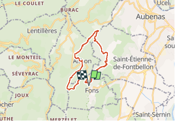
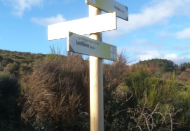
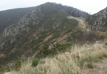
Tour Wandern von 13,5 km verfügbar auf Auvergne-Rhone-Alpen, Ardèche, Fons. Diese Tour wird von coureursdecretes vorgeschlagen.
Beschreibung
Balade variée et sans difficulté, Montées et descentes modérées sauf une descente après Ailhon. Parking suffisant pour une dizaine de voitures au départ du sentier.
Ort
Land:
France
Region :
Auvergne-Rhone-Alpen
Abteilung/Provinz :
Ardèche
Kommune :
Fons
Standort:
Unknown
Gehen Sie:(Dec)
Gehen Sie:(UTM)
606892 ; 4937756 (31T) N.
Kommentare
Touren in der Umgebung
![Tour Wandern Lentillères - Lentillières_les cretes_les Hameaux-13-02-17 - Photo](https://media.geolcdn.com/t/375/260/b26fd82a-80a8-4147-8d0f-0d41ac6326b3.jpg&format=jpg&maxdim=2)
![Wandern Wandern](https://static1.geolcdn.com/sitytour/trail-icons/101.png)
Lentillières_les cretes_les Hameaux-13-02-17
Wandern
Sehr leicht
(1)
Lentillères,
Auvergne-Rhone-Alpen,
Ardèche,
France
![](/images/other/stat-length.png)
12,2 km | 18,7 km-effort
3h 58min
![](https://static1.geolcdn.com/siteimages/upload/files/16400158638029165_repeat_loop_refresh_sync_direction_icon.png)
Ja
![Tour Wandern Largentière - 07 largentiere joannas taurier - Photo](https://media.geolcdn.com/t/375/260/77296687-ec5d-41c6-a098-e5d87fb442f3.jpg&format=jpg&maxdim=2)
![Wandern Wandern](https://static1.geolcdn.com/sitytour/trail-icons/101.png)
07 largentiere joannas taurier
Wandern
Medium
Largentière,
Auvergne-Rhone-Alpen,
Ardèche,
France
![](/images/other/stat-length.png)
24 km | 36 km-effort
8h 40min
![](https://static1.geolcdn.com/siteimages/upload/files/16400158638029165_repeat_loop_refresh_sync_direction_icon.png)
Ja
![Wandern Wandern](https://static1.geolcdn.com/sitytour/trail-icons/101.png)
2024-09-25_21h25m23_Ailhon 9km
Wandern
Medium
Ailhon,
Auvergne-Rhone-Alpen,
Ardèche,
France
![](/images/other/stat-length.png)
8,3 km | 11,7 km-effort
2h 39min
![](https://static1.geolcdn.com/siteimages/upload/files/16400158638029165_repeat_loop_refresh_sync_direction_icon.png)
Ja
![Tour sport Saint-Sernin - 2024-05-10_14h11m42_serre de vinobre - v3 (2) - Photo](https://media.geolcdn.com/t/375/260/ext.jpg?maxdim=2&url=https%3A%2F%2Fsecurestorage.geolives.com%2Fsitytour%2Ftrail-bg%2Fdefault.jpg)
2024-05-10_14h11m42_serre de vinobre - v3 (2)
sport
Sehr leicht
(1)
Saint-Sernin,
Auvergne-Rhone-Alpen,
Ardèche,
France
![](/images/other/stat-length.png)
6,5 km | 9,1 km-effort
Unbekannt
![](https://static1.geolcdn.com/siteimages/upload/files/16400158638029165_repeat_loop_refresh_sync_direction_icon.png)
Ja
![Wandern Wandern](https://static1.geolcdn.com/sitytour/trail-icons/101.png)
2023-03-20_16h29m52_Chazeaux 9km.GPX.xml
Wandern
Schwierig
Chazeaux,
Auvergne-Rhone-Alpen,
Ardèche,
France
![](/images/other/stat-length.png)
8,3 km | 13,4 km-effort
3h 0min
![](https://static1.geolcdn.com/siteimages/upload/files/16400158638029165_repeat_loop_refresh_sync_direction_icon.png)
Ja
![Tour Zu Fuß Vogüé - Vogue Lanas Vinobre - Photo](https://media.geolcdn.com/t/375/260/37f306ce-f2b2-4791-9d17-53a96e7a9e96.jpeg&format=jpg&maxdim=2)
![Zu Fuß Zu Fuß](https://static1.geolcdn.com/sitytour/trail-icons/100.png)
Vogue Lanas Vinobre
Zu Fuß
Medium
Vogüé,
Auvergne-Rhone-Alpen,
Ardèche,
France
![](/images/other/stat-length.png)
16,8 km | 22 km-effort
5h 1min
![](https://static1.geolcdn.com/siteimages/upload/files/16400158638029165_repeat_loop_refresh_sync_direction_icon.png)
Ja
![Tour Wandern Lentillères - Crêtes de Lentilleres - Photo](https://media.geolcdn.com/t/375/260/2b107a6d-80b7-4b48-a6e0-d934a718f25e.jpg&format=jpg&maxdim=2)
![Wandern Wandern](https://static1.geolcdn.com/sitytour/trail-icons/101.png)
Crêtes de Lentilleres
Wandern
Sehr leicht
(1)
Lentillères,
Auvergne-Rhone-Alpen,
Ardèche,
France
![](/images/other/stat-length.png)
12,1 km | 18,9 km-effort
4h 52min
![](https://static1.geolcdn.com/siteimages/upload/files/16400158638029165_repeat_loop_refresh_sync_direction_icon.png)
Ja
![Tour Wandern Chassiers - Balade à Largentière - Photo](https://media.geolcdn.com/t/375/260/ext.jpg?maxdim=2&url=https%3A%2F%2Fservices.sitytrail.com%2FGeolivesWS%2FDownloadMedia.ashx%3FTrailID%3D316903%26Media%3D16001_5.jpg)
![Wandern Wandern](https://static1.geolcdn.com/sitytour/trail-icons/101.png)
Balade à Largentière
Wandern
Medium
Chassiers,
Auvergne-Rhone-Alpen,
Ardèche,
France
![](/images/other/stat-length.png)
4,7 km | 6,4 km-effort
45min
![](https://static1.geolcdn.com/siteimages/upload/files/16400158638029165_repeat_loop_refresh_sync_direction_icon.png)
Ja
![Tour Wandern Largentière - Le Tanargue en 2 jours - Photo](https://media.geolcdn.com/t/375/260/ext.jpg?maxdim=2&url=https%3A%2F%2Fservices.sitytrail.com%2FGeolivesWS%2FDownloadMedia.ashx%3FTrailID%3D268723%26Media%3Dfix__20140420115831.jpg)
![Wandern Wandern](https://static1.geolcdn.com/sitytour/trail-icons/101.png)
Le Tanargue en 2 jours
Wandern
Sehr schwierig
Largentière,
Auvergne-Rhone-Alpen,
Ardèche,
France
![](/images/other/stat-length.png)
65 km | 100 km-effort
15h 52min
![](https://static1.geolcdn.com/siteimages/upload/files/16400158638029165_repeat_loop_refresh_sync_direction_icon.png)
Nein