![](/images/other/stat-length.png)
![Tour Wandern Bourg-Saint-Christophe - 01-bourg-st-christ-perouges-restau-23km-330m - Photo](https://media.geolcdn.com/t/1900/400/a9c5e53e-7fbb-44d0-ada4-e1265a3e43a4.jpg&format=pjpeg&maxdim=2)
01-bourg-st-christ-perouges-restau-23km-330m
SyMA
Benutzer
![Länge](/images/other/stat-length.png)
Länge
24 km
![Maximale Höhe](https://static1.geolcdn.com/siteimages/upload/files/1508320355ic_sort_altitude_max_24dp.png)
Maximale Höhe
290 m
![Positive Höhendifferenz](https://static1.geolcdn.com/siteimages/upload/files/1508320355ic_sort_den_pos_24dp.png)
Positive Höhendifferenz
326 m
![Km-Effort](/images/other/stat-length.png)
Km-Effort
28 km
![Min. Höhe](https://static1.geolcdn.com/siteimages/upload/files/1508320355ic_sort_altitude_min_24dp.png)
Min. Höhe
216 m
![Negative Höhendifferenz](https://static1.geolcdn.com/siteimages/upload/files/1508320355ic_sort_den_neg_24dp.png)
Negative Höhendifferenz
324 m
![Boucle](https://static1.geolcdn.com/siteimages/upload/files/16400158638029165_repeat_loop_refresh_sync_direction_icon.png)
Boucle
Ja
Erstellungsdatum :
2023-02-02 07:51:45.315
Letzte Änderung :
2023-02-03 17:15:38.103
![Wandern](https://static1.geolcdn.com/sitytour/trail-icons/101.png)
6h11
Schwierigkeit : Schwierig
![Scannen Sie diesen QR-Code, um die Tour in der SityTrail-Anwendung zu öffnen](https://capi.geolives.com/qq0zvz2zws4bq2lad0pu/sitytour/trails/3538575/qr.png?size=200)
Kostenlosegpshiking-Anwendung
Über SityTrail
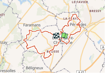
Tour Wandern von 24 km verfügbar auf Auvergne-Rhone-Alpen, Ain, Bourg-Saint-Christophe. Diese Tour wird von SyMA vorgeschlagen.
Beschreibung
Départ cimetiere de Bourg St Christophe
Restau Bienvenu chez Francky
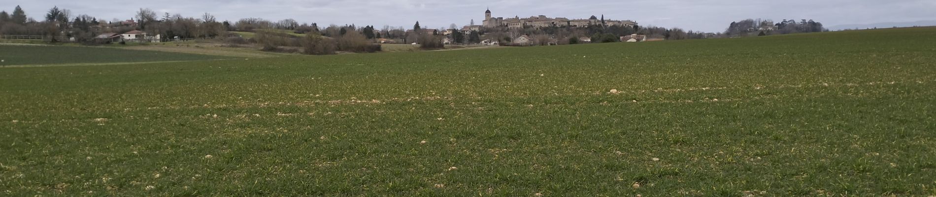
Passage par Perouges pour galette de Perouges
Ort
Land:
France
Region :
Auvergne-Rhone-Alpen
Abteilung/Provinz :
Ain
Kommune :
Bourg-Saint-Christophe
Standort:
Unknown
Gehen Sie:(Dec)
Gehen Sie:(UTM)
667492 ; 5083981 (31T) N.
Kommentare
Touren in der Umgebung
![Tour Wandern Pérouges - autour de pérouges - Photo](https://media.geolcdn.com/t/375/260/ext.jpg?maxdim=2&url=https%3A%2F%2Fstatic1.geolcdn.com%2Fsiteimages%2Fupload%2Ffiles%2F1553511878bg_sport_marche.png)
![Wandern Wandern](https://static1.geolcdn.com/sitytour/trail-icons/101.png)
autour de pérouges
Wandern
Einfach
(1)
Pérouges,
Auvergne-Rhone-Alpen,
Ain,
France
![](/images/other/stat-length.png)
6 km | 7,4 km-effort
1h 34min
![](https://static1.geolcdn.com/siteimages/upload/files/16400158638029165_repeat_loop_refresh_sync_direction_icon.png)
Ja
![Tour Wandern Pérouges - Pérouges-La Boucle de Pérouges - Photo](https://media.geolcdn.com/t/375/260/d6a47359-4b51-4e7d-8142-59e7ac42edd4.jpg&format=jpg&maxdim=2)
![Wandern Wandern](https://static1.geolcdn.com/sitytour/trail-icons/101.png)
Pérouges-La Boucle de Pérouges
Wandern
Medium
Pérouges,
Auvergne-Rhone-Alpen,
Ain,
France
![](/images/other/stat-length.png)
5,9 km | 7,5 km-effort
1h 53min
![](https://static1.geolcdn.com/siteimages/upload/files/16400158638029165_repeat_loop_refresh_sync_direction_icon.png)
Ja
![Tour Wandern Bourg-Saint-Christophe - belignieu - Photo](https://media.geolcdn.com/t/375/260/ext.jpg?maxdim=2&url=https%3A%2F%2Fstatic1.geolcdn.com%2Fsiteimages%2Fupload%2Ffiles%2F1553511878bg_sport_marche.png)
![Wandern Wandern](https://static1.geolcdn.com/sitytour/trail-icons/101.png)
belignieu
Wandern
Sehr leicht
(3)
Bourg-Saint-Christophe,
Auvergne-Rhone-Alpen,
Ain,
France
![](/images/other/stat-length.png)
10,5 km | 11,9 km-effort
1h 0min
![](https://static1.geolcdn.com/siteimages/upload/files/16400158638029165_repeat_loop_refresh_sync_direction_icon.png)
Ja
![Tour Mountainbike Meximieux - De Breurey lès Faverney à Vignieu en VTT- Étape 6/6 - Photo](https://media.geolcdn.com/t/375/260/ext.jpg?maxdim=2&url=https%3A%2F%2Fservices.sitytrail.com%2FGeolivesWS%2FDownloadMedia.ashx%3FTrailID%3D105971%26Media%3D10069_6.jpg)
![Mountainbike Mountainbike](https://static1.geolcdn.com/sitytour/trail-icons/202.png)
De Breurey lès Faverney à Vignieu en VTT- Étape 6/6
Mountainbike
Schwierig
Meximieux,
Auvergne-Rhone-Alpen,
Ain,
France
![](/images/other/stat-length.png)
55 km | 61 km-effort
7h 15min
![](https://static1.geolcdn.com/siteimages/upload/files/16400158638029165_repeat_loop_refresh_sync_direction_icon.png)
Nein
![Tour Rennrad Pérouges - 01 Pérouges velo - Photo](https://media.geolcdn.com/t/375/260/ext.jpg?maxdim=2&url=https%3A%2F%2Fstatic1.geolcdn.com%2Fsiteimages%2Fupload%2Ffiles%2F1524743154velo.jpg)
![Rennrad Rennrad](https://static1.geolcdn.com/sitytour/trail-icons/201.png)
01 Pérouges velo
Rennrad
Medium
Pérouges,
Auvergne-Rhone-Alpen,
Ain,
France
![](/images/other/stat-length.png)
75 km | 82 km-effort
7h 5min
![](https://static1.geolcdn.com/siteimages/upload/files/16400158638029165_repeat_loop_refresh_sync_direction_icon.png)
Ja
![Tour Reiten Pérouges - perouges/pizay/perouges - Photo](https://media.geolcdn.com/t/375/260/ext.jpg?maxdim=2&url=https%3A%2F%2Fstatic1.geolcdn.com%2Fsiteimages%2Fupload%2Ffiles%2F1524743154cheval.jpg)
![Reiten Reiten](https://static1.geolcdn.com/sitytour/trail-icons/301.png)
perouges/pizay/perouges
Reiten
Schwierig
Pérouges,
Auvergne-Rhone-Alpen,
Ain,
France
![](/images/other/stat-length.png)
29 km | 33 km-effort
4h 18min
![](https://static1.geolcdn.com/siteimages/upload/files/16400158638029165_repeat_loop_refresh_sync_direction_icon.png)
Ja
![Tour sport Pérouges - 2024-01-26_18h42m11_boucle-perouges-1 - Photo](https://media.geolcdn.com/t/375/260/ext.jpg?maxdim=2&url=https%3A%2F%2Fsecurestorage.geolives.com%2Fsitytour%2Ftrail-bg%2Fdefault.jpg)
2024-01-26_18h42m11_boucle-perouges-1
sport
Sehr leicht
Pérouges,
Auvergne-Rhone-Alpen,
Ain,
France
![](/images/other/stat-length.png)
52 km | 61 km-effort
Unbekannt
![](https://static1.geolcdn.com/siteimages/upload/files/16400158638029165_repeat_loop_refresh_sync_direction_icon.png)
Ja
![Tour sport Pérouges - Boucle Pérouges 1 - Photo](https://media.geolcdn.com/t/375/260/ext.jpg?maxdim=2&url=https%3A%2F%2Fsecurestorage.geolives.com%2Fsitytour%2Ftrail-bg%2Fdefault.jpg)
Boucle Pérouges 1
sport
Sehr leicht
Pérouges,
Auvergne-Rhone-Alpen,
Ain,
France
![](/images/other/stat-length.png)
52 km | 61 km-effort
Unbekannt
![](https://static1.geolcdn.com/siteimages/upload/files/16400158638029165_repeat_loop_refresh_sync_direction_icon.png)
Ja
![Tour Wandern Pérouges - Andrea cléa - Photo](https://media.geolcdn.com/t/375/260/ext.jpg?maxdim=2&url=https%3A%2F%2Fstatic1.geolcdn.com%2Fsiteimages%2Fupload%2Ffiles%2F1553511878bg_sport_marche.png)
![Wandern Wandern](https://static1.geolcdn.com/sitytour/trail-icons/101.png)
Andrea cléa
Wandern
Einfach
Pérouges,
Auvergne-Rhone-Alpen,
Ain,
France
![](/images/other/stat-length.png)
4,6 km | 5,8 km-effort
1h 55min
![](https://static1.geolcdn.com/siteimages/upload/files/16400158638029165_repeat_loop_refresh_sync_direction_icon.png)
Ja