![](/images/other/stat-length.png)
![Tour Schneeschuhwandern Entraunes - Tête de la Boucharde - Photo](https://media.geolcdn.com/t/1900/400/5d5c8bf3-90ea-4499-9e75-8d36ad4a26c7.jpg&format=pjpeg&maxdim=2)
Tête de la Boucharde
bozo1970
Benutzer
![Länge](/images/other/stat-length.png)
![Maximale Höhe](https://static1.geolcdn.com/siteimages/upload/files/1508320355ic_sort_altitude_max_24dp.png)
![Positive Höhendifferenz](https://static1.geolcdn.com/siteimages/upload/files/1508320355ic_sort_den_pos_24dp.png)
![Km-Effort](/images/other/stat-length.png)
![Min. Höhe](https://static1.geolcdn.com/siteimages/upload/files/1508320355ic_sort_altitude_min_24dp.png)
![Negative Höhendifferenz](https://static1.geolcdn.com/siteimages/upload/files/1508320355ic_sort_den_neg_24dp.png)
![Boucle](https://static1.geolcdn.com/siteimages/upload/files/16400158638029165_repeat_loop_refresh_sync_direction_icon.png)
![Schneeschuhwandern](https://static1.geolcdn.com/sitytour/trail-icons/504.png)
4h09
Schwierigkeit : Medium
![Scannen Sie diesen QR-Code, um die Tour in der SityTrail-Anwendung zu öffnen](https://capi.geolives.com/qq0zvz2zws4bq2lad0pu/sitytour/trails/3538284/qr.png?size=200)
Kostenlosegpshiking-Anwendung
Über SityTrail
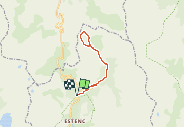
Tour Schneeschuhwandern von 10,9 km verfügbar auf Provence-Alpes-Côte d'Azur, Seealpen, Entraunes. Diese Tour wird von bozo1970 vorgeschlagen.
Beschreibung
Montée par les cabanes de Sanguinière
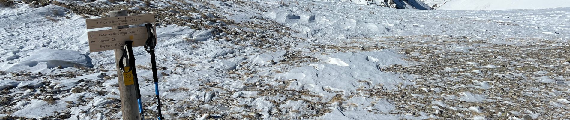
Ravin de la Boucharde
Col de la Boucharde en 2h28’, 5km550 et D 632m
Tête de la Boucharde en 2h45’’, 6km et D 741m
Vue fabuleuse sur le col de la petite Cayolle, le refuge de la Cayolle, la cîme de l’Eschillon, la tête de Sanguinière, le Sanguinerette et pointe côte de l’âne
Retour dans la pente et par le chemin de montée car il y a une zone protégée pour le grand Tétra !!
A/R en 4h09’ et 11km200
Ort
Kommentare
Touren in der Umgebung
![Tour Wandern Uvernet-Fours - Mercantour Le Cimet 3020 m - Photo](https://media.geolcdn.com/t/375/260/ext.jpg?maxdim=2&url=https%3A%2F%2Fservices.sitytrail.com%2FGeolivesWS%2FDownloadMedia.ashx%3FTrailID%3D224622%26Media%3D20130930134741.jpg)
![Wandern Wandern](https://static1.geolcdn.com/sitytour/trail-icons/101.png)
Wandern
![](/images/other/stat-length.png)
![](https://static1.geolcdn.com/siteimages/upload/files/16400158638029165_repeat_loop_refresh_sync_direction_icon.png)
![Wandern Wandern](https://static1.geolcdn.com/sitytour/trail-icons/101.png)
Wandern
![](/images/other/stat-length.png)
![](https://static1.geolcdn.com/siteimages/upload/files/16400158638029165_repeat_loop_refresh_sync_direction_icon.png)
![Tour Wandern Allos - ALLOS. LAC D ALLOS. COL DE LACAYOLE .O - Photo](https://media.geolcdn.com/t/375/260/dff6c4e7-81d7-4f55-8309-f016e1c29cdc.jpg&format=jpg&maxdim=2)
![Wandern Wandern](https://static1.geolcdn.com/sitytour/trail-icons/101.png)
Wandern
![](/images/other/stat-length.png)
![](https://static1.geolcdn.com/siteimages/upload/files/16400158638029165_repeat_loop_refresh_sync_direction_icon.png)
![Wandern Wandern](https://static1.geolcdn.com/sitytour/trail-icons/101.png)
Wandern
![](/images/other/stat-length.png)
![](https://static1.geolcdn.com/siteimages/upload/files/16400158638029165_repeat_loop_refresh_sync_direction_icon.png)
![Tour Zu Fuß Entraunes - Circuit des Lacs - Photo](https://media.geolcdn.com/t/375/260/a896acce-5a5d-4d38-a76c-8521eb37107d.jpeg&format=jpg&maxdim=2)
![Zu Fuß Zu Fuß](https://static1.geolcdn.com/sitytour/trail-icons/100.png)
Zu Fuß
![](/images/other/stat-length.png)
![](https://static1.geolcdn.com/siteimages/upload/files/16400158638029165_repeat_loop_refresh_sync_direction_icon.png)
![Tour Zu Fuß Entraunes - Col de la Boucharde - Photo](https://media.geolcdn.com/t/375/260/3f8fb4f1-6b5f-4291-a48f-766ff65dc022.jpeg&format=jpg&maxdim=2)
![Zu Fuß Zu Fuß](https://static1.geolcdn.com/sitytour/trail-icons/100.png)
Zu Fuß
![](/images/other/stat-length.png)
![](https://static1.geolcdn.com/siteimages/upload/files/16400158638029165_repeat_loop_refresh_sync_direction_icon.png)
![Tour Zu Fuß Entraunes - Tête de la Boulière - Photo](https://media.geolcdn.com/t/375/260/4b7ce69a-b9c1-4af6-a119-2b6bf9e9add8.jpeg&format=jpg&maxdim=2)
![Zu Fuß Zu Fuß](https://static1.geolcdn.com/sitytour/trail-icons/100.png)
Zu Fuß
![](/images/other/stat-length.png)
![](https://static1.geolcdn.com/siteimages/upload/files/16400158638029165_repeat_loop_refresh_sync_direction_icon.png)
![Tour Wandern Allos - le mont Pelat et le lac du trou de l'aigle - Photo](https://media.geolcdn.com/t/375/260/ext.jpg?maxdim=2&url=https%3A%2F%2Fservices.sitytrail.com%2FGeolivesWS%2FDownloadMedia.ashx%3FTrailID%3D791325%26Media%3D36a05fdf-444e-4dea-af98-fa2a609b54f1.JPG)
![Wandern Wandern](https://static1.geolcdn.com/sitytour/trail-icons/101.png)
Wandern
![](/images/other/stat-length.png)
![](https://static1.geolcdn.com/siteimages/upload/files/16400158638029165_repeat_loop_refresh_sync_direction_icon.png)
![Tour Zu Fuß Uvernet-Fours - Circuit des lacs, 04-09-2024 - Photo](https://media.geolcdn.com/t/375/260/09012fd6-d42d-4279-856d-5992e350195b.jpg&format=jpg&maxdim=2)
![Zu Fuß Zu Fuß](https://static1.geolcdn.com/sitytour/trail-icons/100.png)
Zu Fuß
![](/images/other/stat-length.png)
![](https://static1.geolcdn.com/siteimages/upload/files/16400158638029165_repeat_loop_refresh_sync_direction_icon.png)