![](/images/other/stat-length.png)
![Tour Wandern Seillans - Tour du Lac de Meault - Photo](https://media.geolcdn.com/t/1900/400/ext.pjpeg?maxdim=2&url=https%3A%2F%2Fstatic1.geolcdn.com%2Fsiteimages%2Fupload%2Ffiles%2F1553511878bg_sport_marche.png)
Tour du Lac de Meault
aljac
Benutzer
![Länge](/images/other/stat-length.png)
Länge
7,4 km
![Maximale Höhe](https://static1.geolcdn.com/siteimages/upload/files/1508320355ic_sort_altitude_max_24dp.png)
Maximale Höhe
267 m
![Positive Höhendifferenz](https://static1.geolcdn.com/siteimages/upload/files/1508320355ic_sort_den_pos_24dp.png)
Positive Höhendifferenz
162 m
![Km-Effort](/images/other/stat-length.png)
Km-Effort
9,6 km
![Min. Höhe](https://static1.geolcdn.com/siteimages/upload/files/1508320355ic_sort_altitude_min_24dp.png)
Min. Höhe
185 m
![Negative Höhendifferenz](https://static1.geolcdn.com/siteimages/upload/files/1508320355ic_sort_den_neg_24dp.png)
Negative Höhendifferenz
161 m
![Boucle](https://static1.geolcdn.com/siteimages/upload/files/16400158638029165_repeat_loop_refresh_sync_direction_icon.png)
Boucle
Ja
Erstellungsdatum :
2023-01-31 17:45:05.785
Letzte Änderung :
2023-01-31 17:51:04.429
![Wandern](https://static1.geolcdn.com/sitytour/trail-icons/101.png)
2h10
Schwierigkeit : Medium
![Scannen Sie diesen QR-Code, um die Tour in der SityTrail-Anwendung zu öffnen](https://capi.geolives.com/qq0zvz2zws4bq2lad0pu/sitytour/trails/3536279/qr.png?size=200)
Kostenlosegpshiking-Anwendung
Über SityTrail
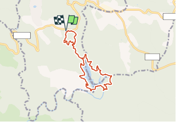
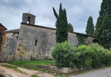
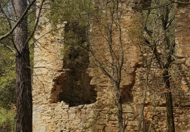
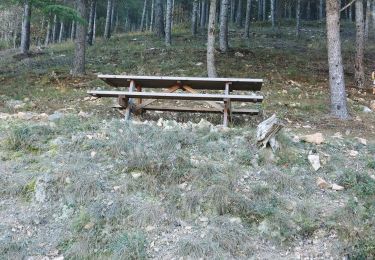
Tour Wandern von 7,4 km verfügbar auf Provence-Alpes-Côte d'Azur, Var, Seillans. Diese Tour wird von aljac vorgeschlagen.
Beschreibung
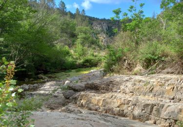
Randonnée effectuée en 1h58. La traversée en aval du déversoir peut présenter un danger. Suivre le marquage jaune (récent).
Ort
Land:
France
Region :
Provence-Alpes-Côte d'Azur
Abteilung/Provinz :
Var
Kommune :
Seillans
Standort:
Unknown
Gehen Sie:(Dec)
Gehen Sie:(UTM)
308785 ; 4827946 (32T) N.
Kommentare
Touren in der Umgebung
![Tour Wandern Callas - gorge de Penafore - Photo](https://media.geolcdn.com/t/375/260/19f2f069-7b40-4577-819a-e6663f6d8c61.jpg&format=jpg&maxdim=2)
![Wandern Wandern](https://static1.geolcdn.com/sitytour/trail-icons/101.png)
gorge de Penafore
Wandern
Sehr leicht
(1)
Callas,
Provence-Alpes-Côte d'Azur,
Var,
France
![](/images/other/stat-length.png)
1,1 km | 1,3 km-effort
1h 33min
![](https://static1.geolcdn.com/siteimages/upload/files/16400158638029165_repeat_loop_refresh_sync_direction_icon.png)
Ja
![Tour Zu Fuß Bagnols-en-Forêt - BAGNOLS EN FORET- Bois du défens DRI - Photo](https://media.geolcdn.com/t/375/260/ext.jpg?maxdim=2&url=https%3A%2F%2Fstatic1.geolcdn.com%2Fsiteimages%2Fupload%2Ffiles%2F1545311037marcheuse_200dpi.jpg)
![Zu Fuß Zu Fuß](https://static1.geolcdn.com/sitytour/trail-icons/100.png)
BAGNOLS EN FORET- Bois du défens DRI
Zu Fuß
Einfach
(2)
Bagnols-en-Forêt,
Provence-Alpes-Côte d'Azur,
Var,
France
![](/images/other/stat-length.png)
9,3 km | 12,7 km-effort
2h 52min
![](https://static1.geolcdn.com/siteimages/upload/files/16400158638029165_repeat_loop_refresh_sync_direction_icon.png)
Ja
![Tour sport Bagnols-en-Forêt - Lac Rioutard Bagnols en forêt - Photo](https://media.geolcdn.com/t/375/260/0154e3c4-4912-418f-af0f-e920b58b6bc0.jpg&format=jpg&maxdim=2)
Lac Rioutard Bagnols en forêt
sport
Sehr leicht
Bagnols-en-Forêt,
Provence-Alpes-Côte d'Azur,
Var,
France
![](/images/other/stat-length.png)
17,5 km | 23 km-effort
Unbekannt
![](https://static1.geolcdn.com/siteimages/upload/files/16400158638029165_repeat_loop_refresh_sync_direction_icon.png)
Ja
![Tour Wandern Fayence - Fayence. Le circuit des trois chapelles - Photo](https://media.geolcdn.com/t/375/260/441da39e-224e-4e50-b6f0-490d073d6503.jpg&format=jpg&maxdim=2)
![Wandern Wandern](https://static1.geolcdn.com/sitytour/trail-icons/101.png)
Fayence. Le circuit des trois chapelles
Wandern
Medium
Fayence,
Provence-Alpes-Côte d'Azur,
Var,
France
![](/images/other/stat-length.png)
15 km | 18,3 km-effort
4h 39min
![](https://static1.geolcdn.com/siteimages/upload/files/16400158638029165_repeat_loop_refresh_sync_direction_icon.png)
Ja
![Tour Wandern Seillans - Lac de Méaulx - Photo](https://media.geolcdn.com/t/375/260/b678c47e-c211-45af-8f95-9193a892a418.jpg&format=jpg&maxdim=2)
![Wandern Wandern](https://static1.geolcdn.com/sitytour/trail-icons/101.png)
Lac de Méaulx
Wandern
Medium
Seillans,
Provence-Alpes-Côte d'Azur,
Var,
France
![](/images/other/stat-length.png)
7,3 km | 9,5 km-effort
2h 9min
![](https://static1.geolcdn.com/siteimages/upload/files/16400158638029165_repeat_loop_refresh_sync_direction_icon.png)
Ja
![Tour Wandern Callas - La catalane ,Font Blanche, les Cabanons - Photo](https://media.geolcdn.com/t/375/260/e9f4ef24-554e-428d-99d0-9e136bb11dfd.jpg&format=jpg&maxdim=2)
![Wandern Wandern](https://static1.geolcdn.com/sitytour/trail-icons/101.png)
La catalane ,Font Blanche, les Cabanons
Wandern
Medium
(1)
Callas,
Provence-Alpes-Côte d'Azur,
Var,
France
![](/images/other/stat-length.png)
10,3 km | 14,2 km-effort
3h 19min
![](https://static1.geolcdn.com/siteimages/upload/files/16400158638029165_repeat_loop_refresh_sync_direction_icon.png)
Ja
![Tour Wandern Fayence - FAYENCE - TOUR DES CHAPELLES - Photo](https://media.geolcdn.com/t/375/260/e73cd254-a552-492e-8747-dfbc8bfa6c7b.jpg&format=jpg&maxdim=2)
![Wandern Wandern](https://static1.geolcdn.com/sitytour/trail-icons/101.png)
FAYENCE - TOUR DES CHAPELLES
Wandern
Einfach
(1)
Fayence,
Provence-Alpes-Côte d'Azur,
Var,
France
![](/images/other/stat-length.png)
16,2 km | 21 km-effort
8h 3min
![](https://static1.geolcdn.com/siteimages/upload/files/16400158638029165_repeat_loop_refresh_sync_direction_icon.png)
Ja
![Tour Wandern Seillans - La Pigne - Photo](https://media.geolcdn.com/t/375/260/c2efac09-daf0-46db-8bd0-b025f5018efe.jpg&format=jpg&maxdim=2)
![Wandern Wandern](https://static1.geolcdn.com/sitytour/trail-icons/101.png)
La Pigne
Wandern
Einfach
Seillans,
Provence-Alpes-Côte d'Azur,
Var,
France
![](/images/other/stat-length.png)
16,3 km | 23 km-effort
5h 51min
![](https://static1.geolcdn.com/siteimages/upload/files/16400158638029165_repeat_loop_refresh_sync_direction_icon.png)
Ja
![Tour Wandern Seillans - Le lac de Meaulx - Photo](https://media.geolcdn.com/t/375/260/d32645a6-7c81-435c-86f5-37b6fb104006.jpg&format=jpg&maxdim=2)
![Wandern Wandern](https://static1.geolcdn.com/sitytour/trail-icons/101.png)
Le lac de Meaulx
Wandern
Medium
Seillans,
Provence-Alpes-Côte d'Azur,
Var,
France
![](/images/other/stat-length.png)
10,8 km | 13,7 km-effort
2h 26min
![](https://static1.geolcdn.com/siteimages/upload/files/16400158638029165_repeat_loop_refresh_sync_direction_icon.png)
Ja
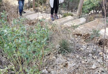
When you arrive on the dam, there is a tricky part for about 2m. Only room for 1 foot.