![](/images/other/stat-length.png)
![Tour Skiwanderen Orcières - L'homme de Prapic - Photo](https://media.geolcdn.com/t/1900/400/728ac5de-7771-4482-8258-55cd8c2ebd98.jpg&format=pjpeg&maxdim=2)
L'homme de Prapic
nadd73
Benutzer GUIDE
![Länge](/images/other/stat-length.png)
Länge
15,8 km
![Maximale Höhe](https://static1.geolcdn.com/siteimages/upload/files/1508320355ic_sort_altitude_max_24dp.png)
Maximale Höhe
2848 m
![Positive Höhendifferenz](https://static1.geolcdn.com/siteimages/upload/files/1508320355ic_sort_den_pos_24dp.png)
Positive Höhendifferenz
1315 m
![Km-Effort](/images/other/stat-length.png)
Km-Effort
33 km
![Min. Höhe](https://static1.geolcdn.com/siteimages/upload/files/1508320355ic_sort_altitude_min_24dp.png)
Min. Höhe
1559 m
![Negative Höhendifferenz](https://static1.geolcdn.com/siteimages/upload/files/1508320355ic_sort_den_neg_24dp.png)
Negative Höhendifferenz
1314 m
![Boucle](https://static1.geolcdn.com/siteimages/upload/files/16400158638029165_repeat_loop_refresh_sync_direction_icon.png)
Boucle
Ja
Erstellungsdatum :
2023-01-26 08:37:39.851
Letzte Änderung :
2023-01-26 18:19:34.322
![Skiwanderen](https://static1.geolcdn.com/sitytour/trail-icons/503.png)
4h34
Schwierigkeit : Medium
![Scannen Sie diesen QR-Code, um die Tour in der SityTrail-Anwendung zu öffnen](https://capi.geolives.com/qq0zvz2zws4bq2lad0pu/sitytour/trails/3531211/qr.png?size=200)
Kostenlosegpshiking-Anwendung
Über SityTrail
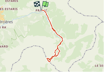
Tour Skiwanderen von 15,8 km verfügbar auf Provence-Alpes-Côte d'Azur, Hochalpen, Orcières. Diese Tour wird von nadd73 vorgeschlagen.
Beschreibung
Départ de Prapic.
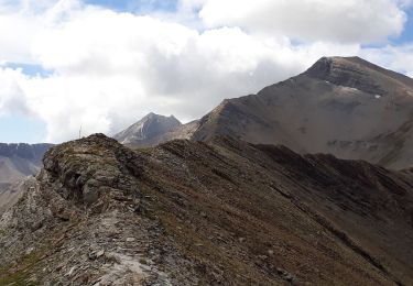
Je suis passée au col de Chargé et montée l'arête SE.
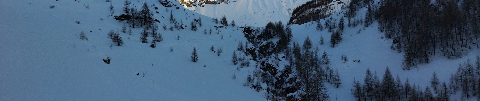
Encore une randonnée avec de la poudreuse.
Ort
Land:
France
Region :
Provence-Alpes-Côte d'Azur
Abteilung/Provinz :
Hochalpen
Kommune :
Orcières
Standort:
Unknown
Gehen Sie:(Dec)
Gehen Sie:(UTM)
291580 ; 4952235 (32T) N.
Kommentare
Touren in der Umgebung
![Tour Wandern Orcières - Le Forest des marches - Photo](https://media.geolcdn.com/t/375/260/1bbb2305-7ec0-44b0-abf9-1e50226e1407.jpg&format=jpg&maxdim=2)
![Wandern Wandern](https://static1.geolcdn.com/sitytour/trail-icons/101.png)
Le Forest des marches
Wandern
Einfach
(2)
Orcières,
Provence-Alpes-Côte d'Azur,
Hochalpen,
France
![](/images/other/stat-length.png)
6,3 km | 9,9 km-effort
1h 42min
![](https://static1.geolcdn.com/siteimages/upload/files/16400158638029165_repeat_loop_refresh_sync_direction_icon.png)
Ja
![Tour Wandern Orcières - R45 Marmottes a Prapic - Photo](https://media.geolcdn.com/t/375/260/9e9dbd3a-1b41-4834-8fb6-1b5270d2390e.jpg&format=jpg&maxdim=2)
![Wandern Wandern](https://static1.geolcdn.com/sitytour/trail-icons/101.png)
R45 Marmottes a Prapic
Wandern
Medium
(2)
Orcières,
Provence-Alpes-Côte d'Azur,
Hochalpen,
France
![](/images/other/stat-length.png)
9 km | 14 km-effort
2h 57min
![](https://static1.geolcdn.com/siteimages/upload/files/16400158638029165_repeat_loop_refresh_sync_direction_icon.png)
Ja
![Tour Wandern Orcières - Orcieres (Hautes Alpes) - Photo](https://media.geolcdn.com/t/375/260/8cda8352-22b8-4c39-b048-400b3169e428.jpg&format=jpg&maxdim=2)
![Wandern Wandern](https://static1.geolcdn.com/sitytour/trail-icons/101.png)
Orcieres (Hautes Alpes)
Wandern
Sehr schwierig
(1)
Orcières,
Provence-Alpes-Côte d'Azur,
Hochalpen,
France
![](/images/other/stat-length.png)
12 km | 19,4 km-effort
4h 24min
![](https://static1.geolcdn.com/siteimages/upload/files/16400158638029165_repeat_loop_refresh_sync_direction_icon.png)
Ja
![Tour Wandern Orcières - Roc Diolon par le col de Fressinieres 11/08/23 - Photo](https://media.geolcdn.com/t/375/260/5a167a74-49bc-4637-b777-9bd30e412110.jpg&format=jpg&maxdim=2)
![Wandern Wandern](https://static1.geolcdn.com/sitytour/trail-icons/101.png)
Roc Diolon par le col de Fressinieres 11/08/23
Wandern
Sehr schwierig
Orcières,
Provence-Alpes-Côte d'Azur,
Hochalpen,
France
![](/images/other/stat-length.png)
16,3 km | 32 km-effort
7h 21min
![](https://static1.geolcdn.com/siteimages/upload/files/16400158638029165_repeat_loop_refresh_sync_direction_icon.png)
Ja
![Wandern Wandern](https://static1.geolcdn.com/sitytour/trail-icons/101.png)
Saut du Laire
Wandern
Medium
Orcières,
Provence-Alpes-Côte d'Azur,
Hochalpen,
France
![](/images/other/stat-length.png)
11,4 km | 18,9 km-effort
4h 17min
![](https://static1.geolcdn.com/siteimages/upload/files/16400158638029165_repeat_loop_refresh_sync_direction_icon.png)
Ja
![Tour Wandern Orcières - Lac des Pisses - Photo](https://media.geolcdn.com/t/375/260/72d69359-d69b-4e79-86c6-e3022c079ec2.jpg&format=jpg&maxdim=2)
![Wandern Wandern](https://static1.geolcdn.com/sitytour/trail-icons/101.png)
Lac des Pisses
Wandern
Schwierig
Orcières,
Provence-Alpes-Côte d'Azur,
Hochalpen,
France
![](/images/other/stat-length.png)
13,2 km | 26 km-effort
5h 58min
![](https://static1.geolcdn.com/siteimages/upload/files/16400158638029165_repeat_loop_refresh_sync_direction_icon.png)
Ja
![Tour Skiwanderen Orcières - objectif Rocher blanc mais trop long donc direction chapeau rouge - Photo](https://media.geolcdn.com/t/375/260/7cce85a4-567c-43a2-8949-4f1bb1d57721.jpg&format=jpg&maxdim=2)
![Skiwanderen Skiwanderen](https://static1.geolcdn.com/sitytour/trail-icons/503.png)
objectif Rocher blanc mais trop long donc direction chapeau rouge
Skiwanderen
Medium
Orcières,
Provence-Alpes-Côte d'Azur,
Hochalpen,
France
![](/images/other/stat-length.png)
17,2 km | 32 km-effort
6h 0min
![](https://static1.geolcdn.com/siteimages/upload/files/16400158638029165_repeat_loop_refresh_sync_direction_icon.png)
Ja
![Tour Skiwanderen Orcières - Le chapeau rouge - Photo](https://media.geolcdn.com/t/375/260/4359da6c-2220-46c4-9d30-4f44fc07feb5.jpg&format=jpg&maxdim=2)
![Skiwanderen Skiwanderen](https://static1.geolcdn.com/sitytour/trail-icons/503.png)
Le chapeau rouge
Skiwanderen
Medium
Orcières,
Provence-Alpes-Côte d'Azur,
Hochalpen,
France
![](/images/other/stat-length.png)
16 km | 31 km-effort
5h 54min
![](https://static1.geolcdn.com/siteimages/upload/files/16400158638029165_repeat_loop_refresh_sync_direction_icon.png)
Ja
![Tour Wandern Orcières - Col des Tourettes - Croix Lorraine 08/09/18 - Photo](https://media.geolcdn.com/t/375/260/af57e72a-0044-4f3d-888f-9184aa14c00c.jpg&format=jpg&maxdim=2)
![Wandern Wandern](https://static1.geolcdn.com/sitytour/trail-icons/101.png)
Col des Tourettes - Croix Lorraine 08/09/18
Wandern
Schwierig
Orcières,
Provence-Alpes-Côte d'Azur,
Hochalpen,
France
![](/images/other/stat-length.png)
21 km | 37 km-effort
5h 30min
![](https://static1.geolcdn.com/siteimages/upload/files/16400158638029165_repeat_loop_refresh_sync_direction_icon.png)
Ja