![](/images/other/stat-length.png)
![Tour Reiten La Chapelle - SityTrail - OKBOUILLON Route MADAME proposition DNF Bouillon - Photo](https://media.geolcdn.com/t/1900/400/9dc51392-1e6d-4132-be55-dbd7539f47f4.png&format=pjpeg&maxdim=2)
SityTrail - OKBOUILLON Route MADAME proposition DNF Bouillon
DUPONT Rita
Benutzer GUIDE
![Länge](/images/other/stat-length.png)
Länge
19,3 km
![Maximale Höhe](https://static1.geolcdn.com/siteimages/upload/files/1508320355ic_sort_altitude_max_24dp.png)
Maximale Höhe
442 m
![Positive Höhendifferenz](https://static1.geolcdn.com/siteimages/upload/files/1508320355ic_sort_den_pos_24dp.png)
Positive Höhendifferenz
395 m
![Km-Effort](/images/other/stat-length.png)
Km-Effort
25 km
![Min. Höhe](https://static1.geolcdn.com/siteimages/upload/files/1508320355ic_sort_altitude_min_24dp.png)
Min. Höhe
218 m
![Negative Höhendifferenz](https://static1.geolcdn.com/siteimages/upload/files/1508320355ic_sort_den_neg_24dp.png)
Negative Höhendifferenz
578 m
![Boucle](https://static1.geolcdn.com/siteimages/upload/files/16400158638029165_repeat_loop_refresh_sync_direction_icon.png)
Boucle
Nein
Erstellungsdatum :
2023-01-25 07:54:54.571
Letzte Änderung :
2024-05-27 06:42:44.789
![Reiten](https://static1.geolcdn.com/sitytour/trail-icons/301.png)
3h18
Schwierigkeit : Medium
![Scannen Sie diesen QR-Code, um die Tour in der SityTrail-Anwendung zu öffnen](https://capi.geolives.com/qq0zvz2zws4bq2lad0pu/sitytour/trails/3529410/qr.png?size=200)
Kostenlosegpshiking-Anwendung
Über SityTrail
Tour Reiten von 19,3 km verfügbar auf Großer Osten, Ardennes, La Chapelle. Diese Tour wird von DUPONT Rita vorgeschlagen.
Beschreibung
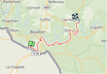
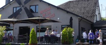
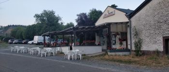
De la frontière française vers Bouillon, Dohan en passant par des gués, relais : hébergements, restauration et halte. Collaboration : LEWB
Ort
Land:
France
Region :
Großer Osten
Abteilung/Provinz :
Ardennes
Kommune :
La Chapelle
Standort:
Unknown
Gehen Sie:(Dec)
Gehen Sie:(UTM)
647201 ; 5514768 (31U) N.
Kommentare
Touren in der Umgebung
![Tour Wandern Bouillon - RB-LUX-13 - Les belvédères bouillonnais - Photo](https://media.geolcdn.com/t/375/260/ext.jpg?maxdim=2&url=https%3A%2F%2Fservices.sitytrail.com%2FGeolivesWS%2FDownloadMedia.ashx%3FTrailID%3D179618%26Media%3Dc93ae6e1-6a5c-490e-ab2b-3f360dd3a9f8.jpg)
![Wandern Wandern](https://static1.geolcdn.com/sitytour/trail-icons/101.png)
RB-LUX-13 - Les belvédères bouillonnais
Wandern
Medium
(8)
Bouillon,
Wallonien,
Luxemburg,
Belgium
![](/images/other/stat-length.png)
20 km | 30 km-effort
5h 55min
![](https://static1.geolcdn.com/siteimages/upload/files/16400158638029165_repeat_loop_refresh_sync_direction_icon.png)
Ja
![Tour Wandern Bouillon - Marche ADEPS à Bouillon 8km500 - Photo](https://media.geolcdn.com/t/375/260/1579ffd1-b437-4fe4-a5cc-0a3a87fba898.jpg&format=jpg&maxdim=2)
![Wandern Wandern](https://static1.geolcdn.com/sitytour/trail-icons/101.png)
Marche ADEPS à Bouillon 8km500
Wandern
Schwierig
(1)
Bouillon,
Wallonien,
Luxemburg,
Belgium
![](/images/other/stat-length.png)
8,4 km | 12,5 km-effort
2h 28min
![](https://static1.geolcdn.com/siteimages/upload/files/16400158638029165_repeat_loop_refresh_sync_direction_icon.png)
Ja
![Tour Wandern Bouillon - RB-LUX-13 - Raccourci - Les belvédères bouillonnais - Photo](https://media.geolcdn.com/t/375/260/ext.jpg?maxdim=2&url=https%3A%2F%2Fservices.sitytrail.com%2FGeolivesWS%2FDownloadMedia.ashx%3FTrailID%3D216805%26Media%3Dc93ae6e1-6a5c-490e-ab2b-3f360dd3a9f8.jpg)
![Wandern Wandern](https://static1.geolcdn.com/sitytour/trail-icons/101.png)
RB-LUX-13 - Raccourci - Les belvédères bouillonnais
Wandern
Medium
(4)
Bouillon,
Wallonien,
Luxemburg,
Belgium
![](/images/other/stat-length.png)
16,7 km | 25 km-effort
4h 54min
![](https://static1.geolcdn.com/siteimages/upload/files/16400158638029165_repeat_loop_refresh_sync_direction_icon.png)
Ja
![Tour Wandern Bouillon - De Corbion à la Roche aux Eperviers - Photo](https://media.geolcdn.com/t/375/260/ext.jpg?maxdim=2&url=https%3A%2F%2Fservices.sitytrail.com%2FGeolivesWS%2FDownloadMedia.ashx%3FTrailID%3D146950%26Media%3D6d765926-55f0-4539-a611-ffe05c9bf6d8.JPG)
![Wandern Wandern](https://static1.geolcdn.com/sitytour/trail-icons/101.png)
De Corbion à la Roche aux Eperviers
Wandern
Einfach
(2)
Bouillon,
Wallonien,
Luxemburg,
Belgium
![](/images/other/stat-length.png)
10,6 km | 14,6 km-effort
2h 50min
![](https://static1.geolcdn.com/siteimages/upload/files/16400158638029165_repeat_loop_refresh_sync_direction_icon.png)
Ja
![Tour Wandern Bouillon - De Poupehan à Frahan par le sentier des crêtes - Photo](https://media.geolcdn.com/t/375/260/ext.jpg?maxdim=2&url=https%3A%2F%2Fservices.sitytrail.com%2FGeolivesWS%2FDownloadMedia.ashx%3FTrailID%3D138478%26Media%3Db86d13b9-d40b-4a52-ab60-15a552c97303.JPG)
![Wandern Wandern](https://static1.geolcdn.com/sitytour/trail-icons/101.png)
De Poupehan à Frahan par le sentier des crêtes
Wandern
Medium
(3)
Bouillon,
Wallonien,
Luxemburg,
Belgium
![](/images/other/stat-length.png)
8,8 km | 12,5 km-effort
3h 0min
![](https://static1.geolcdn.com/siteimages/upload/files/16400158638029165_repeat_loop_refresh_sync_direction_icon.png)
Ja
![Tour Wandern Bouillon - De Corbion à Poupehan par la Roche des Fées et la Chaire à Prêcher - Photo](https://media.geolcdn.com/t/375/260/ext.jpg?maxdim=2&url=https%3A%2F%2Fservices.sitytrail.com%2FGeolivesWS%2FDownloadMedia.ashx%3FTrailID%3D138476%26Media%3D05b27b25-8086-41d3-96c5-76c508b6a7d7.JPG)
![Wandern Wandern](https://static1.geolcdn.com/sitytour/trail-icons/101.png)
De Corbion à Poupehan par la Roche des Fées et la Chaire à Prêcher
Wandern
Medium
(2)
Bouillon,
Wallonien,
Luxemburg,
Belgium
![](/images/other/stat-length.png)
7,3 km | 11,1 km-effort
3h 0min
![](https://static1.geolcdn.com/siteimages/upload/files/16400158638029165_repeat_loop_refresh_sync_direction_icon.png)
Ja
![Tour Wandern Bouillon - Corbion - Le Sentier des Points de Vue - Photo](https://media.geolcdn.com/t/375/260/ext.jpg?maxdim=2&url=https%3A%2F%2Fservices.sitytrail.com%2FGeolivesWS%2FDownloadMedia.ashx%3FTrailID%3D138106%26Media%3D530b3448-4c03-4266-ae4e-a2076c332785.JPG)
![Wandern Wandern](https://static1.geolcdn.com/sitytour/trail-icons/101.png)
Corbion - Le Sentier des Points de Vue
Wandern
Medium
(7)
Bouillon,
Wallonien,
Luxemburg,
Belgium
![](/images/other/stat-length.png)
8,6 km | 12,2 km-effort
3h 0min
![](https://static1.geolcdn.com/siteimages/upload/files/16400158638029165_repeat_loop_refresh_sync_direction_icon.png)
Ja
![Tour Wandern Bouillon - Promenade vers la Passerelle de l’épine - Photo](https://media.geolcdn.com/t/375/260/a030b44f-54a7-48fb-92fc-a78ebfcb2520.jpg&format=jpg&maxdim=2)
![Wandern Wandern](https://static1.geolcdn.com/sitytour/trail-icons/101.png)
Promenade vers la Passerelle de l’épine
Wandern
Medium
(8)
Bouillon,
Wallonien,
Luxemburg,
Belgium
![](/images/other/stat-length.png)
7,3 km | 11,2 km-effort
2h 33min
![](https://static1.geolcdn.com/siteimages/upload/files/16400158638029165_repeat_loop_refresh_sync_direction_icon.png)
Ja
![Tour Wandern Bouillon - Poupehan_Rochehaut_Frahan_Poupzhan - Photo](https://media.geolcdn.com/t/375/260/0b4f111d-644c-4d33-b812-a15a1b8098b1.jpg&format=jpg&maxdim=2)
![Wandern Wandern](https://static1.geolcdn.com/sitytour/trail-icons/101.png)
Poupehan_Rochehaut_Frahan_Poupzhan
Wandern
Medium
(4)
Bouillon,
Wallonien,
Luxemburg,
Belgium
![](/images/other/stat-length.png)
12,8 km | 18,7 km-effort
5h 7min
![](https://static1.geolcdn.com/siteimages/upload/files/16400158638029165_repeat_loop_refresh_sync_direction_icon.png)
Ja