![](/images/other/stat-length.png)
![Tour Wandern Santa Cruz de Tenerife - 20230123 Tachero-Taganana-Afur-Tamarides-Taganana - Photo](https://media.geolcdn.com/t/1900/400/5e74cb13-69fc-4368-a6b5-97a9ce371819.jpg&format=pjpeg&maxdim=2)
20230123 Tachero-Taganana-Afur-Tamarides-Taganana
ThonyM
Benutzer
![Länge](/images/other/stat-length.png)
Länge
16 km
![Maximale Höhe](https://static1.geolcdn.com/siteimages/upload/files/1508320355ic_sort_altitude_max_24dp.png)
Maximale Höhe
611 m
![Positive Höhendifferenz](https://static1.geolcdn.com/siteimages/upload/files/1508320355ic_sort_den_pos_24dp.png)
Positive Höhendifferenz
953 m
![Km-Effort](/images/other/stat-length.png)
Km-Effort
29 km
![Min. Höhe](https://static1.geolcdn.com/siteimages/upload/files/1508320355ic_sort_altitude_min_24dp.png)
Min. Höhe
2 m
![Negative Höhendifferenz](https://static1.geolcdn.com/siteimages/upload/files/1508320355ic_sort_den_neg_24dp.png)
Negative Höhendifferenz
955 m
![Boucle](https://static1.geolcdn.com/siteimages/upload/files/16400158638029165_repeat_loop_refresh_sync_direction_icon.png)
Boucle
Ja
Erstellungsdatum :
2023-01-23 08:59:03.0
Letzte Änderung :
2023-01-23 15:23:20.753
![Wandern](https://static1.geolcdn.com/sitytour/trail-icons/101.png)
4h37
Schwierigkeit : Schwierig
![Scannen Sie diesen QR-Code, um die Tour in der SityTrail-Anwendung zu öffnen](https://capi.geolives.com/qq0zvz2zws4bq2lad0pu/sitytour/trails/3527925/qr.png?size=200)
Kostenlosegpshiking-Anwendung
Über SityTrail
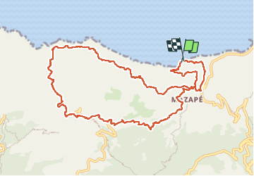
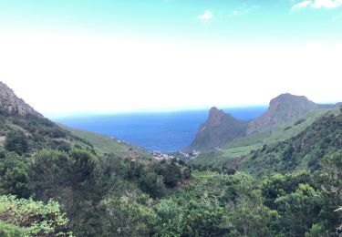
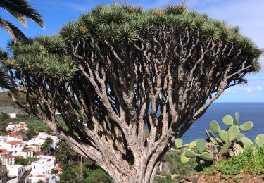
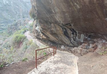
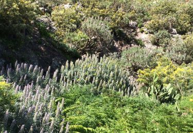
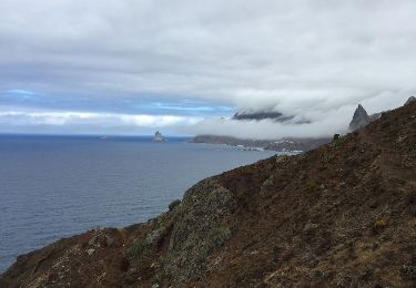
Tour Wandern von 16 km verfügbar auf Kanarische Inseln, Santa Cruz de Tenerife, Santa Cruz de Tenerife. Diese Tour wird von ThonyM vorgeschlagen.
Beschreibung
Les pieds parfois mouillés pour traverser des gués. Les panneaux indiquent que le sentier entre Tamarides et Taganana n’est pas praticable: nous n’avons rencontré aucune difficulté
Ort
Land:
Spain
Region :
Kanarische Inseln
Abteilung/Provinz :
Santa Cruz de Tenerife
Kommune :
Santa Cruz de Tenerife
Standort:
Anaga
Gehen Sie:(Dec)
Gehen Sie:(UTM)
380523 ; 3160569 (28R) N.
Kommentare
Touren in der Umgebung
![Tour Wandern Santa Cruz de Tenerife - Tenerife-Circuit du Chinobre n°53-28.03.16 - Photo](https://media.geolcdn.com/t/375/260/ext.jpg?maxdim=2&url=https%3A%2F%2Fstatic1.geolcdn.com%2Fsiteimages%2Fupload%2Ffiles%2F1553511878bg_sport_marche.png)
![Wandern Wandern](https://static1.geolcdn.com/sitytour/trail-icons/101.png)
Tenerife-Circuit du Chinobre n°53-28.03.16
Wandern
Einfach
(1)
Santa Cruz de Tenerife,
Kanarische Inseln,
Santa Cruz de Tenerife,
Spain
![](/images/other/stat-length.png)
7,3 km | 11,2 km-effort
2h 14min
![](https://static1.geolcdn.com/siteimages/upload/files/16400158638029165_repeat_loop_refresh_sync_direction_icon.png)
Ja
![Tour Wandern Santa Cruz de Tenerife - BENIJO - El Draguillo - Photo](https://media.geolcdn.com/t/375/260/c466f058-6d07-42db-8769-224c2e12c676.jpg&format=jpg&maxdim=2)
![Wandern Wandern](https://static1.geolcdn.com/sitytour/trail-icons/101.png)
BENIJO - El Draguillo
Wandern
Medium
Santa Cruz de Tenerife,
Kanarische Inseln,
Santa Cruz de Tenerife,
Spain
![](/images/other/stat-length.png)
5,2 km | 11 km-effort
1h 40min
![](https://static1.geolcdn.com/siteimages/upload/files/16400158638029165_repeat_loop_refresh_sync_direction_icon.png)
Ja
![Tour Wandern Santa Cruz de Tenerife - 20230128 boucle Tâcheron - Amalciga - Photo](https://media.geolcdn.com/t/375/260/b1f1dc85-b9e4-4caa-b65a-f459c97ad4be.jpg&format=jpg&maxdim=2)
![Wandern Wandern](https://static1.geolcdn.com/sitytour/trail-icons/101.png)
20230128 boucle Tâcheron - Amalciga
Wandern
Medium
Santa Cruz de Tenerife,
Kanarische Inseln,
Santa Cruz de Tenerife,
Spain
![](/images/other/stat-length.png)
12,9 km | 22 km-effort
3h 9min
![](https://static1.geolcdn.com/siteimages/upload/files/16400158638029165_repeat_loop_refresh_sync_direction_icon.png)
Nein
![Tour Wandern Santa Cruz de Tenerife - 20230125 Tachero-Taganana-Casa Forestal - Photo](https://media.geolcdn.com/t/375/260/71cc47a6-b1dd-4c81-86b4-433999439594.jpg&format=jpg&maxdim=2)
![Wandern Wandern](https://static1.geolcdn.com/sitytour/trail-icons/101.png)
20230125 Tachero-Taganana-Casa Forestal
Wandern
Schwierig
Santa Cruz de Tenerife,
Kanarische Inseln,
Santa Cruz de Tenerife,
Spain
![](/images/other/stat-length.png)
13 km | 25 km-effort
3h 47min
![](https://static1.geolcdn.com/siteimages/upload/files/16400158638029165_repeat_loop_refresh_sync_direction_icon.png)
Nein
![Tour Wandern Santa Cruz de Tenerife - 20230121 Tacheros-Taganana- el Baleiros - Photo](https://media.geolcdn.com/t/375/260/d3298b11-553a-417f-a8c1-0c2a9e5ffc75.jpg&format=jpg&maxdim=2)
![Wandern Wandern](https://static1.geolcdn.com/sitytour/trail-icons/101.png)
20230121 Tacheros-Taganana- el Baleiros
Wandern
Medium
Santa Cruz de Tenerife,
Kanarische Inseln,
Santa Cruz de Tenerife,
Spain
![](/images/other/stat-length.png)
12,9 km | 23 km-effort
3h 14min
![](https://static1.geolcdn.com/siteimages/upload/files/16400158638029165_repeat_loop_refresh_sync_direction_icon.png)
Nein
![Tour Wandern Santa Cruz de Tenerife - Afur - Taganana - Photo](https://media.geolcdn.com/t/375/260/3c968652-f4ba-48a3-a0da-108b9b20f163.jpg&format=jpg&maxdim=2)
![Wandern Wandern](https://static1.geolcdn.com/sitytour/trail-icons/101.png)
Afur - Taganana
Wandern
Medium
Santa Cruz de Tenerife,
Kanarische Inseln,
Santa Cruz de Tenerife,
Spain
![](/images/other/stat-length.png)
12,3 km | 22 km-effort
4h 53min
![](https://static1.geolcdn.com/siteimages/upload/files/16400158638029165_repeat_loop_refresh_sync_direction_icon.png)
Ja
![Zu Fuß Zu Fuß](https://static1.geolcdn.com/sitytour/trail-icons/100.png)
Pico del Ingles circulaire
Zu Fuß
Medium
Santa Cruz de Tenerife,
Kanarische Inseln,
Santa Cruz de Tenerife,
Spain
![](/images/other/stat-length.png)
9,2 km | 17 km-effort
4h 0min
![](https://static1.geolcdn.com/siteimages/upload/files/16400158638029165_repeat_loop_refresh_sync_direction_icon.png)
Ja
![Tour Andere Aktivitäten Santa Cruz de Tenerife - taganana afur taganana par la mer - Photo](https://media.geolcdn.com/t/375/260/ext.jpg?maxdim=2&url=https%3A%2F%2Fservices.sitytrail.com%2FGeolivesWS%2FDownloadMedia.ashx%3FTrailID%3D1023224%26Media%3D20180816164504.jpg)
![Andere Aktivitäten Andere Aktivitäten](https://static1.geolcdn.com/sitytour/trail-icons/900.png)
taganana afur taganana par la mer
Andere Aktivitäten
Medium
Santa Cruz de Tenerife,
Kanarische Inseln,
Santa Cruz de Tenerife,
Spain
![](/images/other/stat-length.png)
14,4 km | 25 km-effort
6h 30min
![](https://static1.geolcdn.com/siteimages/upload/files/16400158638029165_repeat_loop_refresh_sync_direction_icon.png)
Ja
![Tour Wandern Santa Cruz de Tenerife - Canaries - Tenerife - Massif d'Anaga/Afur - jour 10 - Photo](https://media.geolcdn.com/t/375/260/ext.jpg?maxdim=2&url=https%3A%2F%2Fstatic1.geolcdn.com%2Fsiteimages%2Fupload%2Ffiles%2F1553511878bg_sport_marche.png)
![Wandern Wandern](https://static1.geolcdn.com/sitytour/trail-icons/101.png)
Canaries - Tenerife - Massif d'Anaga/Afur - jour 10
Wandern
Sehr schwierig
Santa Cruz de Tenerife,
Kanarische Inseln,
Santa Cruz de Tenerife,
Spain
![](/images/other/stat-length.png)
10,2 km | 19,4 km-effort
6h 54min
![](https://static1.geolcdn.com/siteimages/upload/files/16400158638029165_repeat_loop_refresh_sync_direction_icon.png)
Ja