![](/images/other/stat-length.png)
![Tour Wandern Sigy-le-Châtel - Sigy Le Chatel - Photo](https://media.geolcdn.com/t/1900/400/ext.pjpeg?maxdim=2&url=https%3A%2F%2Fstatic1.geolcdn.com%2Fsiteimages%2Fupload%2Ffiles%2F1553511878bg_sport_marche.png)
Sigy Le Chatel
Bonnefois Bernard
Benutzer
![Länge](/images/other/stat-length.png)
Länge
10,7 km
![Maximale Höhe](https://static1.geolcdn.com/siteimages/upload/files/1508320355ic_sort_altitude_max_24dp.png)
Maximale Höhe
409 m
![Positive Höhendifferenz](https://static1.geolcdn.com/siteimages/upload/files/1508320355ic_sort_den_pos_24dp.png)
Positive Höhendifferenz
248 m
![Km-Effort](/images/other/stat-length.png)
Km-Effort
14 km
![Min. Höhe](https://static1.geolcdn.com/siteimages/upload/files/1508320355ic_sort_altitude_min_24dp.png)
Min. Höhe
217 m
![Negative Höhendifferenz](https://static1.geolcdn.com/siteimages/upload/files/1508320355ic_sort_den_neg_24dp.png)
Negative Höhendifferenz
260 m
![Boucle](https://static1.geolcdn.com/siteimages/upload/files/16400158638029165_repeat_loop_refresh_sync_direction_icon.png)
Boucle
Ja
Erstellungsdatum :
2023-01-13 20:21:56.255
Letzte Änderung :
2023-03-07 17:37:45.528
![Wandern](https://static1.geolcdn.com/sitytour/trail-icons/101.png)
3h11
Schwierigkeit : Einfach
![Scannen Sie diesen QR-Code, um die Tour in der SityTrail-Anwendung zu öffnen](https://capi.geolives.com/qq0zvz2zws4bq2lad0pu/sitytour/trails/3517960/qr.png?size=200)
Kostenlosegpshiking-Anwendung
Über SityTrail
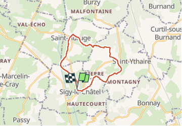
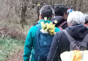
Tour Wandern von 10,7 km verfügbar auf Burgund und Freigrafschaft, Saône-et-Loire, Sigy-le-Châtel. Diese Tour wird von Bonnefois Bernard vorgeschlagen.
Beschreibung
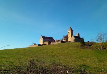
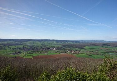
Randonnée de 1km permettant de visiter les villages et châteaux de Sigy le Chatel et Saint-Huruge avec dr jolies vues sur la vallée de la Guye et depuis le belvédère de Chassignol
Ort
Land:
France
Region :
Burgund und Freigrafschaft
Abteilung/Provinz :
Saône-et-Loire
Kommune :
Sigy-le-Châtel
Standort:
Unknown
Gehen Sie:(Dec)
Gehen Sie:(UTM)
620550 ; 5157022 (31T) N.
Kommentare
Touren in der Umgebung
![Tour Wandern Saint-Ythaire - Saint Ythaire Les Jonquilles page 104 - Photo](https://media.geolcdn.com/t/375/260/b715c419-f0c8-4081-851b-031d98b992f8.jpg&format=jpg&maxdim=2)
![Wandern Wandern](https://static1.geolcdn.com/sitytour/trail-icons/101.png)
Saint Ythaire Les Jonquilles page 104
Wandern
Medium
(5)
Saint-Ythaire,
Burgund und Freigrafschaft,
Saône-et-Loire,
France
![](/images/other/stat-length.png)
12,3 km | 17,2 km-effort
3h 36min
![](https://static1.geolcdn.com/siteimages/upload/files/16400158638029165_repeat_loop_refresh_sync_direction_icon.png)
Ja
![Tour Wandern Saint-Ythaire - 2023-03-04_12h49m01_SityTrail - 2356343 - saint-ythaire--les-jonquilles-page-104 - Photo](https://media.geolcdn.com/t/375/260/ext.jpg?maxdim=2&url=https%3A%2F%2Fstatic1.geolcdn.com%2Fsiteimages%2Fupload%2Ffiles%2F1553511878bg_sport_marche.png)
![Wandern Wandern](https://static1.geolcdn.com/sitytour/trail-icons/101.png)
2023-03-04_12h49m01_SityTrail - 2356343 - saint-ythaire--les-jonquilles-page-104
Wandern
Schwierig
(1)
Saint-Ythaire,
Burgund und Freigrafschaft,
Saône-et-Loire,
France
![](/images/other/stat-length.png)
12,3 km | 17,2 km-effort
3h 54min
![](https://static1.geolcdn.com/siteimages/upload/files/16400158638029165_repeat_loop_refresh_sync_direction_icon.png)
Ja
![Tour Mountainbike Bonnay - Besanceuil - Photo](https://media.geolcdn.com/t/375/260/ext.jpg?maxdim=2&url=https%3A%2F%2Fstatic1.geolcdn.com%2Fsiteimages%2Fupload%2Ffiles%2F1524743154velo.jpg)
![Mountainbike Mountainbike](https://static1.geolcdn.com/sitytour/trail-icons/202.png)
Besanceuil
Mountainbike
Medium
(1)
Bonnay,
Burgund und Freigrafschaft,
Saône-et-Loire,
France
![](/images/other/stat-length.png)
11,2 km | 15,7 km-effort
3h 52min
![](https://static1.geolcdn.com/siteimages/upload/files/16400158638029165_repeat_loop_refresh_sync_direction_icon.png)
Ja
![Tour Wandern Saint-Huruge - Mamou cross the hill - Photo](https://media.geolcdn.com/t/375/260/7fc0deed-35cd-4431-9961-efa4dfee15c9.jpg&format=jpg&maxdim=2)
![Wandern Wandern](https://static1.geolcdn.com/sitytour/trail-icons/101.png)
Mamou cross the hill
Wandern
Einfach
Saint-Huruge,
Burgund und Freigrafschaft,
Saône-et-Loire,
France
![](/images/other/stat-length.png)
6,1 km | 7,5 km-effort
1h 52min
![](https://static1.geolcdn.com/siteimages/upload/files/16400158638029165_repeat_loop_refresh_sync_direction_icon.png)
Ja
![Tour Wandern Saint-Ythaire - oh! les beaux village - Photo](https://media.geolcdn.com/t/375/260/3e355eb2-324a-45da-9d1d-1374c4ffb6a4.jpg&format=jpg&maxdim=2)
![Wandern Wandern](https://static1.geolcdn.com/sitytour/trail-icons/101.png)
oh! les beaux village
Wandern
Medium
Saint-Ythaire,
Burgund und Freigrafschaft,
Saône-et-Loire,
France
![](/images/other/stat-length.png)
8,4 km | 11,7 km-effort
2h 28min
![](https://static1.geolcdn.com/siteimages/upload/files/16400158638029165_repeat_loop_refresh_sync_direction_icon.png)
Ja
![Tour Wandern Salornay-sur-Guye - 20190822 Salornay sur Guye G3 GC - Photo](https://media.geolcdn.com/t/375/260/ext.jpg?maxdim=2&url=https%3A%2F%2Fstatic1.geolcdn.com%2Fsiteimages%2Fupload%2Ffiles%2F1553511878bg_sport_marche.png)
![Wandern Wandern](https://static1.geolcdn.com/sitytour/trail-icons/101.png)
20190822 Salornay sur Guye G3 GC
Wandern
Einfach
(1)
Salornay-sur-Guye,
Burgund und Freigrafschaft,
Saône-et-Loire,
France
![](/images/other/stat-length.png)
10,2 km | 14,2 km-effort
3h 2min
![](https://static1.geolcdn.com/siteimages/upload/files/16400158638029165_repeat_loop_refresh_sync_direction_icon.png)
Ja
![Tour Wandern Saint-Ythaire - ythair - Photo](https://media.geolcdn.com/t/375/260/7784352b-2740-4051-ab6d-9d1cb2a374eb.jpg&format=jpg&maxdim=2)
![Wandern Wandern](https://static1.geolcdn.com/sitytour/trail-icons/101.png)
ythair
Wandern
Medium
Saint-Ythaire,
Burgund und Freigrafschaft,
Saône-et-Loire,
France
![](/images/other/stat-length.png)
13,8 km | 19,5 km-effort
3h 21min
![](https://static1.geolcdn.com/siteimages/upload/files/16400158638029165_repeat_loop_refresh_sync_direction_icon.png)
Ja
![Tour Wandern Sigy-le-Châtel - si gt jonquilles - Photo](https://media.geolcdn.com/t/375/260/bc15ae0f-1637-4097-ad31-d924e5201aea.jpg&format=jpg&maxdim=2)
![Wandern Wandern](https://static1.geolcdn.com/sitytour/trail-icons/101.png)
si gt jonquilles
Wandern
Medium
(2)
Sigy-le-Châtel,
Burgund und Freigrafschaft,
Saône-et-Loire,
France
![](/images/other/stat-length.png)
8,4 km | 12 km-effort
3h 15min
![](https://static1.geolcdn.com/siteimages/upload/files/16400158638029165_repeat_loop_refresh_sync_direction_icon.png)
Ja
![Tour Wandern Salornay-sur-Guye - circuit salornay sentier du bois de la roche - Photo](https://media.geolcdn.com/t/375/260/ext.jpg?maxdim=2&url=https%3A%2F%2Fservices.sitytrail.com%2FGeolivesWS%2FDownloadMedia.ashx%3FTrailID%3D721057%26Media%3Dfix__20170326165025.jpg)
![Wandern Wandern](https://static1.geolcdn.com/sitytour/trail-icons/101.png)
circuit salornay sentier du bois de la roche
Wandern
Einfach
Salornay-sur-Guye,
Burgund und Freigrafschaft,
Saône-et-Loire,
France
![](/images/other/stat-length.png)
8,6 km | 11,8 km-effort
2h 8min
![](https://static1.geolcdn.com/siteimages/upload/files/16400158638029165_repeat_loop_refresh_sync_direction_icon.png)
Ja
très belle randonnée,mais pas du tout difficile comme indiqué