![](/images/other/stat-length.png)
![Tour Wandern Echternach - mullerthal trail 1 - Photo](https://media.geolcdn.com/t/1900/400/ext.pjpeg?maxdim=2&url=https%3A%2F%2Fstatic1.geolcdn.com%2Fsiteimages%2Fupload%2Ffiles%2F1553511878bg_sport_marche.png)
mullerthal trail 1
philippedoumont
Benutzer
![Länge](/images/other/stat-length.png)
Länge
44 km
![Maximale Höhe](https://static1.geolcdn.com/siteimages/upload/files/1508320355ic_sort_altitude_max_24dp.png)
Maximale Höhe
406 m
![Positive Höhendifferenz](https://static1.geolcdn.com/siteimages/upload/files/1508320355ic_sort_den_pos_24dp.png)
Positive Höhendifferenz
1046 m
![Km-Effort](/images/other/stat-length.png)
Km-Effort
58 km
![Min. Höhe](https://static1.geolcdn.com/siteimages/upload/files/1508320355ic_sort_altitude_min_24dp.png)
Min. Höhe
156 m
![Negative Höhendifferenz](https://static1.geolcdn.com/siteimages/upload/files/1508320355ic_sort_den_neg_24dp.png)
Negative Höhendifferenz
1046 m
![Boucle](https://static1.geolcdn.com/siteimages/upload/files/16400158638029165_repeat_loop_refresh_sync_direction_icon.png)
Boucle
Ja
Erstellungsdatum :
2014-12-10 00:00:00.0
Letzte Änderung :
2014-12-10 00:00:00.0
![Wandern](https://static1.geolcdn.com/sitytour/trail-icons/101.png)
7h20
Schwierigkeit : Schwierig
![Scannen Sie diesen QR-Code, um die Tour in der SityTrail-Anwendung zu öffnen](https://capi.geolives.com/qq0zvz2zws4bq2lad0pu/sitytour/trails/351750/qr.png?size=200)
Kostenlosegpshiking-Anwendung
Über SityTrail
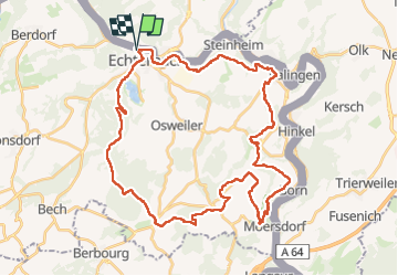
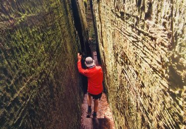
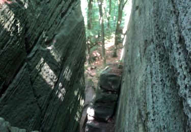
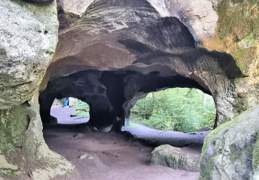
Tour Wandern von 44 km verfügbar auf Unbekannt, Kanton Echternach, Echternach. Diese Tour wird von philippedoumont vorgeschlagen.
Beschreibung
Müllerthal Trail 1: 44km. start vanaf busstation Rue de la Gare Echternach. Gratis parkeren!
Route is duidelijk aangegeven met rode M, alleen eerste km. veel zoeken.
Opmerkingen? flip96@home.nl
Ort
Land:
Luxembourg
Region :
Unbekannt
Abteilung/Provinz :
Kanton Echternach
Kommune :
Echternach
Standort:
Unknown
Gehen Sie:(Dec)
Gehen Sie:(UTM)
314100 ; 5521388 (32U) N.
Kommentare
Touren in der Umgebung
![Tour Wandern Berdorf - Berdorf - B2 - Müllerthal - Photo](https://media.geolcdn.com/t/375/260/517daf86-eb8b-412e-9a7e-d0a346807e81.jpg&format=jpg&maxdim=2)
![Wandern Wandern](https://static1.geolcdn.com/sitytour/trail-icons/101.png)
Berdorf - B2 - Müllerthal
Wandern
Medium
(2)
Berdorf,
Unbekannt,
Kanton Echternach,
Luxembourg
![](/images/other/stat-length.png)
6,7 km | 8,5 km-effort
1h 35min
![](https://static1.geolcdn.com/siteimages/upload/files/16400158638029165_repeat_loop_refresh_sync_direction_icon.png)
Ja
![Tour Wandern Berdorf - 2023-06-03_18h17m36_Sentier_local_-_B8 - Photo](https://media.geolcdn.com/t/375/260/7a8870ac-d558-4a39-b7c2-bdeb26e936c0.jpg&format=jpg&maxdim=2)
![Wandern Wandern](https://static1.geolcdn.com/sitytour/trail-icons/101.png)
2023-06-03_18h17m36_Sentier_local_-_B8
Wandern
Medium
(2)
Berdorf,
Unbekannt,
Kanton Echternach,
Luxembourg
![](/images/other/stat-length.png)
11,7 km | 15 km-effort
3h 24min
![](https://static1.geolcdn.com/siteimages/upload/files/16400158638029165_repeat_loop_refresh_sync_direction_icon.png)
Ja
![Tour Wandern Berdorf - MÜLLERTHAL (Bollendorf-Pont) - Photo](https://media.geolcdn.com/t/375/260/ext.jpg?maxdim=2&url=https%3A%2F%2Fservices.sitytrail.com%2FGeolivesWS%2FDownloadMedia.ashx%3FTrailID%3D816349%26Media%3Dfix__20170824131142.jpg)
![Wandern Wandern](https://static1.geolcdn.com/sitytour/trail-icons/101.png)
MÜLLERTHAL (Bollendorf-Pont)
Wandern
Einfach
(1)
Berdorf,
Unbekannt,
Kanton Echternach,
Luxembourg
![](/images/other/stat-length.png)
10,5 km | 14,3 km-effort
3h 10min
![](https://static1.geolcdn.com/siteimages/upload/files/16400158638029165_repeat_loop_refresh_sync_direction_icon.png)
Ja
![Tour Wandern Ernzen - DeLux Wanderpark Felsenweg1, Weilerbach-Houllay - Photo](https://media.geolcdn.com/t/375/260/ext.jpg?maxdim=2&url=https%3A%2F%2Fstatic1.geolcdn.com%2Fsiteimages%2Fupload%2Ffiles%2F1553511878bg_sport_marche.png)
![Wandern Wandern](https://static1.geolcdn.com/sitytour/trail-icons/101.png)
DeLux Wanderpark Felsenweg1, Weilerbach-Houllay
Wandern
Sehr leicht
(1)
Ernzen,
Rheinland-Pfalz,
Eifelkreis Bitburg-Prüm,
Germany
![](/images/other/stat-length.png)
20 km | 28 km-effort
5h 51min
![](https://static1.geolcdn.com/siteimages/upload/files/16400158638029165_repeat_loop_refresh_sync_direction_icon.png)
Ja
![Tour Wandern Echternach - mullerthal moitié E1 - Photo](https://media.geolcdn.com/t/375/260/d1c68b99-ac30-490b-aea5-f05902ad3f3d.jpg&format=jpg&maxdim=2)
![Wandern Wandern](https://static1.geolcdn.com/sitytour/trail-icons/101.png)
mullerthal moitié E1
Wandern
Medium
Echternach,
Unbekannt,
Kanton Echternach,
Luxembourg
![](/images/other/stat-length.png)
6,3 km | 9,2 km-effort
2h 1min
![](https://static1.geolcdn.com/siteimages/upload/files/16400158638029165_repeat_loop_refresh_sync_direction_icon.png)
Nein
![Tour Wandern Echternach - echternacht tour du lac villa romaine - Photo](https://media.geolcdn.com/t/375/260/702d825c-b429-41af-92ee-f2a109afde03.jpg&format=jpg&maxdim=2)
![Wandern Wandern](https://static1.geolcdn.com/sitytour/trail-icons/101.png)
echternacht tour du lac villa romaine
Wandern
Sehr leicht
Echternach,
Unbekannt,
Kanton Echternach,
Luxembourg
![](/images/other/stat-length.png)
3,4 km | 3,8 km-effort
58min
![](https://static1.geolcdn.com/siteimages/upload/files/16400158638029165_repeat_loop_refresh_sync_direction_icon.png)
Nein
![Tour Wandern Echternach - Itinérant Luxembourg Jour 4 Echternach-Beaufort - Photo](https://media.geolcdn.com/t/375/260/5d9fc501-8c8f-498e-90ca-83c630d1efb6.jpg&format=jpg&maxdim=2)
![Wandern Wandern](https://static1.geolcdn.com/sitytour/trail-icons/101.png)
Itinérant Luxembourg Jour 4 Echternach-Beaufort
Wandern
Sehr schwierig
Echternach,
Unbekannt,
Kanton Echternach,
Luxembourg
![](/images/other/stat-length.png)
25 km | 34 km-effort
6h 39min
![](https://static1.geolcdn.com/siteimages/upload/files/16400158638029165_repeat_loop_refresh_sync_direction_icon.png)
Nein
![Tour Wandern Echternach - Muller 2 - Photo](https://media.geolcdn.com/t/375/260/ac224f96-35e7-4fbc-a1ed-e43957f71bb4.jpg&format=jpg&maxdim=2)
![Wandern Wandern](https://static1.geolcdn.com/sitytour/trail-icons/101.png)
Muller 2
Wandern
Schwierig
Echternach,
Unbekannt,
Kanton Echternach,
Luxembourg
![](/images/other/stat-length.png)
27 km | 36 km-effort
8h 24min
![](https://static1.geolcdn.com/siteimages/upload/files/16400158638029165_repeat_loop_refresh_sync_direction_icon.png)
Nein
![Tour Zu Fuß Echternacherbrück - Felsenweg 1 - Photo](https://media.geolcdn.com/t/375/260/2e9ebe84-c1e3-4839-8a8a-11176ceb2a5c.jpeg&format=jpg&maxdim=2)
![Zu Fuß Zu Fuß](https://static1.geolcdn.com/sitytour/trail-icons/100.png)
Felsenweg 1
Zu Fuß
Medium
Echternacherbrück,
Rheinland-Pfalz,
Eifelkreis Bitburg-Prüm,
Germany
![](/images/other/stat-length.png)
14 km | 20 km-effort
4h 33min
![](https://static1.geolcdn.com/siteimages/upload/files/16400158638029165_repeat_loop_refresh_sync_direction_icon.png)
Nein