![](/images/other/stat-length.png)
![Tour Wandern Gourbeyre - observation volcanique basse tere - Photo](https://media.geolcdn.com/t/1900/400/ext.pjpeg?maxdim=2&url=https%3A%2F%2Fstatic1.geolcdn.com%2Fsiteimages%2Fupload%2Ffiles%2F1553511878bg_sport_marche.png)
observation volcanique basse tere
rprotte
Benutzer
![Länge](/images/other/stat-length.png)
Länge
7 km
![Maximale Höhe](https://static1.geolcdn.com/siteimages/upload/files/1508320355ic_sort_altitude_max_24dp.png)
Maximale Höhe
419 m
![Positive Höhendifferenz](https://static1.geolcdn.com/siteimages/upload/files/1508320355ic_sort_den_pos_24dp.png)
Positive Höhendifferenz
372 m
![Km-Effort](/images/other/stat-length.png)
Km-Effort
11,9 km
![Min. Höhe](https://static1.geolcdn.com/siteimages/upload/files/1508320355ic_sort_altitude_min_24dp.png)
Min. Höhe
32 m
![Negative Höhendifferenz](https://static1.geolcdn.com/siteimages/upload/files/1508320355ic_sort_den_neg_24dp.png)
Negative Höhendifferenz
376 m
![Boucle](https://static1.geolcdn.com/siteimages/upload/files/16400158638029165_repeat_loop_refresh_sync_direction_icon.png)
Boucle
Ja
Erstellungsdatum :
2023-01-07 18:41:27.162
Letzte Änderung :
2023-01-07 21:08:27.533
![Wandern](https://static1.geolcdn.com/sitytour/trail-icons/101.png)
2h02
Schwierigkeit : Medium
![Scannen Sie diesen QR-Code, um die Tour in der SityTrail-Anwendung zu öffnen](https://capi.geolives.com/qq0zvz2zws4bq2lad0pu/sitytour/trails/3511014/qr.png?size=200)
Kostenlosegpshiking-Anwendung
Über SityTrail
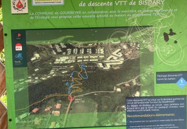
Tour Wandern von 7 km verfügbar auf Guadeloupe, Unbekannt, Gourbeyre. Diese Tour wird von rprotte vorgeschlagen.
Beschreibung
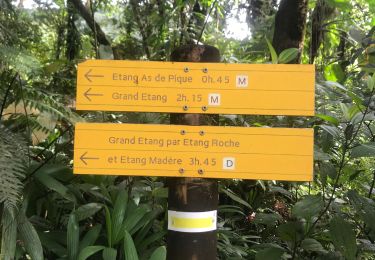
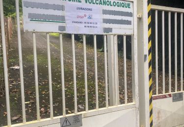
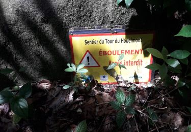
un norceau du chemin fermé pour éboulement. a mi chemin de la route nous pouvions reprendre mais maryse n'a pas souhaité et à préféré rester sur route
Ort
Land:
France
Region :
Guadeloupe
Abteilung/Provinz :
Unbekannt
Kommune :
Gourbeyre
Standort:
Unknown
Gehen Sie:(Dec)
Gehen Sie:(UTM)
637468 ; 1767627 (20P) N.
Kommentare
Touren in der Umgebung
![Tour Nordic Walking Gourbeyre - Centre volcanologique - Photo](https://media.geolcdn.com/t/375/260/22f274fc-26f5-4936-905a-2727595e8dbc.jpg&format=jpg&maxdim=2)
![Nordic Walking Nordic Walking](https://static1.geolcdn.com/sitytour/trail-icons/102.png)
Centre volcanologique
Nordic Walking
Medium
Gourbeyre,
Guadeloupe,
Unbekannt,
France
![](/images/other/stat-length.png)
6,5 km | 11,5 km-effort
1h 45min
![](https://static1.geolcdn.com/siteimages/upload/files/16400158638029165_repeat_loop_refresh_sync_direction_icon.png)
Ja
![Tour Pfad Gourbeyre - Houėlmont observatoire volcanologique - Photo](https://media.geolcdn.com/t/375/260/e3eec2e7-e70a-40a8-adfd-8338ee92c874.jpg&format=jpg&maxdim=2)
![Pfad Pfad](https://static1.geolcdn.com/sitytour/trail-icons/104.png)
Houėlmont observatoire volcanologique
Pfad
Schwierig
Gourbeyre,
Guadeloupe,
Unbekannt,
France
![](/images/other/stat-length.png)
6,4 km | 11,5 km-effort
1h 22min
![](https://static1.geolcdn.com/siteimages/upload/files/16400158638029165_repeat_loop_refresh_sync_direction_icon.png)
Ja
![Tour Pfad Gourbeyre - Gourbeyre - Photo](https://media.geolcdn.com/t/375/260/3ad9e632-d4d0-4b47-89df-42eb811c4e40.jpg&format=jpg&maxdim=2)
![Pfad Pfad](https://static1.geolcdn.com/sitytour/trail-icons/104.png)
Gourbeyre
Pfad
Schwierig
Gourbeyre,
Guadeloupe,
Unbekannt,
France
![](/images/other/stat-length.png)
17,1 km | 27 km-effort
2h 10min
![](https://static1.geolcdn.com/siteimages/upload/files/16400158638029165_repeat_loop_refresh_sync_direction_icon.png)
Ja
![Tour Laufen Basse-Terre - Volcano Trail - Grand Raid de la Région Guadeloupe - Édition 2009 - Photo](https://media.geolcdn.com/t/375/260/ext.jpg?maxdim=2&url=https%3A%2F%2Fservices.sitytrail.com%2FGeolivesWS%2FDownloadMedia.ashx%3FTrailID%3D316801%26Media%3D7294_5.jpg)
![Laufen Laufen](https://static1.geolcdn.com/sitytour/trail-icons/103.png)
Volcano Trail - Grand Raid de la Région Guadeloupe - Édition 2009
Laufen
Sehr schwierig
Basse-Terre,
Guadeloupe,
Unbekannt,
France
![](/images/other/stat-length.png)
44 km | 86 km-effort
11h 30min
![](https://static1.geolcdn.com/siteimages/upload/files/16400158638029165_repeat_loop_refresh_sync_direction_icon.png)
Nein
![Tour Pfad Gourbeyre - Bisdary - Photo](https://media.geolcdn.com/t/375/260/6625daa2-3d52-4d9a-9b0c-f5e561616c00.jpg&format=jpg&maxdim=2)
![Pfad Pfad](https://static1.geolcdn.com/sitytour/trail-icons/104.png)
![Tour Wandern Gourbeyre - La parabole - Photo](https://media.geolcdn.com/t/375/260/4fc388b3-7bf6-4438-b313-deb61f268840.jpg&format=jpg&maxdim=2)
![Wandern Wandern](https://static1.geolcdn.com/sitytour/trail-icons/101.png)
La parabole
Wandern
Medium
Gourbeyre,
Guadeloupe,
Unbekannt,
France
![](/images/other/stat-length.png)
7,1 km | 9,6 km-effort
2h 17min
![](https://static1.geolcdn.com/siteimages/upload/files/16400158638029165_repeat_loop_refresh_sync_direction_icon.png)
Ja
![Tour Wandern Gourbeyre - reco exam poudriere - Photo](https://media.geolcdn.com/t/375/260/60d02808-8d08-49fc-ae78-5271e4a02d1f.jpg&format=jpg&maxdim=2)
![Wandern Wandern](https://static1.geolcdn.com/sitytour/trail-icons/101.png)
reco exam poudriere
Wandern
Medium
Gourbeyre,
Guadeloupe,
Unbekannt,
France
![](/images/other/stat-length.png)
5,5 km | 9,4 km-effort
2h 37min
![](https://static1.geolcdn.com/siteimages/upload/files/16400158638029165_repeat_loop_refresh_sync_direction_icon.png)
Ja
![Tour Wandern Gourbeyre - Boucle du Morne Cadet - Photo](https://media.geolcdn.com/t/375/260/f100b4aa-49fe-47fe-ac23-1583674cc11c.jpg&format=jpg&maxdim=2)
![Wandern Wandern](https://static1.geolcdn.com/sitytour/trail-icons/101.png)
Boucle du Morne Cadet
Wandern
Schwierig
Gourbeyre,
Guadeloupe,
Unbekannt,
France
![](/images/other/stat-length.png)
9,8 km | 18,7 km-effort
5h 46min
![](https://static1.geolcdn.com/siteimages/upload/files/16400158638029165_repeat_loop_refresh_sync_direction_icon.png)
Ja
![Tour Wandern Vieux-Fort - cascade plessis - Photo](https://media.geolcdn.com/t/375/260/44a443e5-7e24-4587-af8a-3bdb25b9e4d7.jpg&format=jpg&maxdim=2)
![Wandern Wandern](https://static1.geolcdn.com/sitytour/trail-icons/101.png)
cascade plessis
Wandern
Sehr leicht
Vieux-Fort,
Guadeloupe,
Unbekannt,
France
![](/images/other/stat-length.png)
11,2 km | 21 km-effort
46min
![](https://static1.geolcdn.com/siteimages/upload/files/16400158638029165_repeat_loop_refresh_sync_direction_icon.png)
Nein