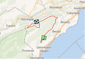
![](/images/other/stat-length.png)
![Tour Andere Aktivitäten La Grande-Béroche - Rando de Pompaples à Mauraz - Photo](https://media.geolcdn.com/t/1900/400/ext.pjpeg?maxdim=2&url=https%3A%2F%2Fstatic1.geolcdn.com%2Fsiteimages%2Fupload%2Ffiles%2F1545311037marcheuse_200dpi.jpg)
Rando de Pompaples à Mauraz
schaffner_la09
Benutzer
![Länge](/images/other/stat-length.png)
![Maximale Höhe](https://static1.geolcdn.com/siteimages/upload/files/1508320355ic_sort_altitude_max_24dp.png)
![Positive Höhendifferenz](https://static1.geolcdn.com/siteimages/upload/files/1508320355ic_sort_den_pos_24dp.png)
![Km-Effort](/images/other/stat-length.png)
![Min. Höhe](https://static1.geolcdn.com/siteimages/upload/files/1508320355ic_sort_altitude_min_24dp.png)
![Negative Höhendifferenz](https://static1.geolcdn.com/siteimages/upload/files/1508320355ic_sort_den_neg_24dp.png)
![Boucle](https://static1.geolcdn.com/siteimages/upload/files/16400158638029165_repeat_loop_refresh_sync_direction_icon.png)
![Andere Aktivitäten](https://static1.geolcdn.com/sitytour/trail-icons/900.png)
--
Schwierigkeit : Unbekannt
![Scannen Sie diesen QR-Code, um die Tour in der SityTrail-Anwendung zu öffnen](https://capi.geolives.com/qq0zvz2zws4bq2lad0pu/sitytour/trails/35066/qr.png?size=200)
Kostenlosegpshiking-Anwendung
Über SityTrail
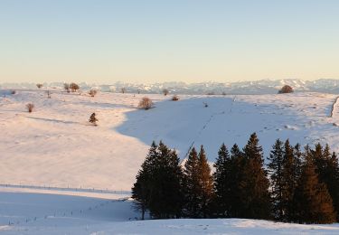
Tour Andere Aktivitäten von 20 km verfügbar auf Neuenburg, Unbekannt, La Grande-Béroche. Diese Tour wird von schaffner_la09 vorgeschlagen.
Beschreibung
Départ d''un parking au bord de la route entre Pompaples et Croy. Par les bois de buis à l''est des falaises des gorges de St-Loup, descendez sur Arnex, puis ensuite dans la plaine de l''Orbe pour un joli galop le long du canal du Nozon. Remontez ensuite dans la forêt d''Entreroches pour apercevoir le Château de la Sarraz. Aussi bien gîte équestre que halte de quelques heures, le Château de la Sarraz accueille les cavaliers dans un site exceptionnel. Neuf anneaux sont prévus pour attacher les chevaux pendant votre visite du musée du cheval, crée en 1982 par les amoureux des chevaux.
Suite de la randonnée à cheval dans les bois de buis, cette fois à l''ouest des gorges de St-Loup. Beau contraste de végétation, avec un petit air du Sud! Suivez ensuite le pied du Jura pour rejoindre le gîte des Crinières du Veyron, à Mauraz (VD). Nuit sous yourte et chevaux au parc ou en boxe.
Au départ du deuxième jour, vous reprendrez un bout le chemin de la veille pour rejoindre ensuite les Bois de Moiry, la réserve naturelle des bois de Chênes et le village de Croy, où de belles et nombreuses fontaines seront sur votre route. Retour par le joli sentier des bois de buis pour retrouver le parking du départ en contrebas.
Ort
Kommentare
Touren in der Umgebung
![Tour Zu Fuß Val-de-Travers - Les Oeuillons-Le Soliat - Photo](https://media.geolcdn.com/t/375/260/d6dbfe3d-16a5-4a11-88ea-3fe674f56dd4.jpeg&format=jpg&maxdim=2)
![Zu Fuß Zu Fuß](https://static1.geolcdn.com/sitytour/trail-icons/100.png)
Zu Fuß
![](/images/other/stat-length.png)
![](https://static1.geolcdn.com/siteimages/upload/files/16400158638029165_repeat_loop_refresh_sync_direction_icon.png)
![Tour Wandern La Grande-Béroche - Vaumarcus - Provence - Mutrux - Vaumarcus 21.09.2019 - Photo](https://media.geolcdn.com/t/375/260/e917a829-5981-489f-829b-99faba2adea2.jpg&format=jpg&maxdim=2)
![Wandern Wandern](https://static1.geolcdn.com/sitytour/trail-icons/101.png)
Wandern
![](/images/other/stat-length.png)
![](https://static1.geolcdn.com/siteimages/upload/files/16400158638029165_repeat_loop_refresh_sync_direction_icon.png)
![Tour Wandern Val-de-Travers - Jour trois Jura - Photo](https://media.geolcdn.com/t/375/260/3138e73a-067b-49d6-a001-5fdda0d138a5.jpg&format=jpg&maxdim=2)
![Wandern Wandern](https://static1.geolcdn.com/sitytour/trail-icons/101.png)
Wandern
![](/images/other/stat-length.png)
![](https://static1.geolcdn.com/siteimages/upload/files/16400158638029165_repeat_loop_refresh_sync_direction_icon.png)
![Tour Pfad Provence - Creux des van - Photo](https://media.geolcdn.com/t/375/260/c9b8247a-118d-467b-8152-6c2f1ae5b769.jpg&format=jpg&maxdim=2)
![Pfad Pfad](https://static1.geolcdn.com/sitytour/trail-icons/104.png)
Pfad
![](/images/other/stat-length.png)
![](https://static1.geolcdn.com/siteimages/upload/files/16400158638029165_repeat_loop_refresh_sync_direction_icon.png)
![Tour Wandern Mutrux - Mutrux-La Genoule-Les Erses - Photo](https://media.geolcdn.com/t/375/260/ext.jpg?maxdim=2&url=https%3A%2F%2Fstatic1.geolcdn.com%2Fsiteimages%2Fupload%2Ffiles%2F1553511878bg_sport_marche.png)
![Wandern Wandern](https://static1.geolcdn.com/sitytour/trail-icons/101.png)
Wandern
![](/images/other/stat-length.png)
![](https://static1.geolcdn.com/siteimages/upload/files/16400158638029165_repeat_loop_refresh_sync_direction_icon.png)
![Tour Wandern Val-de-Travers - Tour du Creux du Van par le Dos d''Âne - Photo](https://media.geolcdn.com/t/375/260/ext.jpg?maxdim=2&url=https%3A%2F%2Fstatic1.geolcdn.com%2Fsiteimages%2Fupload%2Ffiles%2F1553511878bg_sport_marche.png)
![Wandern Wandern](https://static1.geolcdn.com/sitytour/trail-icons/101.png)
Wandern
![](/images/other/stat-length.png)
![](https://static1.geolcdn.com/siteimages/upload/files/16400158638029165_repeat_loop_refresh_sync_direction_icon.png)
![Tour Andere Aktivitäten La Grande-Béroche - La Chaille - Photo](https://media.geolcdn.com/t/375/260/ext.jpg?maxdim=2&url=https%3A%2F%2Fstatic1.geolcdn.com%2Fsiteimages%2Fupload%2Ffiles%2F1545311037marcheuse_200dpi.jpg)
![Andere Aktivitäten Andere Aktivitäten](https://static1.geolcdn.com/sitytour/trail-icons/900.png)
Andere Aktivitäten
![](/images/other/stat-length.png)
![](https://static1.geolcdn.com/siteimages/upload/files/16400158638029165_repeat_loop_refresh_sync_direction_icon.png)
![Tour Andere Aktivitäten Provence - Mutrux - Mont Aubert - Mutrux - Photo](https://media.geolcdn.com/t/375/260/ext.jpg?maxdim=2&url=https%3A%2F%2Fstatic1.geolcdn.com%2Fsiteimages%2Fupload%2Ffiles%2F1545311037marcheuse_200dpi.jpg)
![Andere Aktivitäten Andere Aktivitäten](https://static1.geolcdn.com/sitytour/trail-icons/900.png)
Andere Aktivitäten
![](/images/other/stat-length.png)
![](https://static1.geolcdn.com/siteimages/upload/files/16400158638029165_repeat_loop_refresh_sync_direction_icon.png)
![Tour Andere Aktivitäten Provence - Roche devant - Photo](https://media.geolcdn.com/t/375/260/ext.jpg?maxdim=2&url=https%3A%2F%2Fstatic1.geolcdn.com%2Fsiteimages%2Fupload%2Ffiles%2F1545311037marcheuse_200dpi.jpg)
![Andere Aktivitäten Andere Aktivitäten](https://static1.geolcdn.com/sitytour/trail-icons/900.png)
Andere Aktivitäten
![](/images/other/stat-length.png)
![](https://static1.geolcdn.com/siteimages/upload/files/16400158638029165_repeat_loop_refresh_sync_direction_icon.png)