![](/images/other/stat-length.png)
![Tour Wandern Bouillon - Corbion( bouillon): le sentier des points de vue - Photo](https://media.geolcdn.com/t/1900/400/ext.pjpeg?maxdim=2&url=https%3A%2F%2Fstatic1.geolcdn.com%2Fsiteimages%2Fupload%2Ffiles%2F1553511878bg_sport_marche.png)
Corbion( bouillon): le sentier des points de vue
micheldutilleul
Benutzer
![Länge](/images/other/stat-length.png)
Länge
8,8 km
![Maximale Höhe](https://static1.geolcdn.com/siteimages/upload/files/1508320355ic_sort_altitude_max_24dp.png)
Maximale Höhe
396 m
![Positive Höhendifferenz](https://static1.geolcdn.com/siteimages/upload/files/1508320355ic_sort_den_pos_24dp.png)
Positive Höhendifferenz
293 m
![Km-Effort](/images/other/stat-length.png)
Km-Effort
12,8 km
![Min. Höhe](https://static1.geolcdn.com/siteimages/upload/files/1508320355ic_sort_altitude_min_24dp.png)
Min. Höhe
215 m
![Negative Höhendifferenz](https://static1.geolcdn.com/siteimages/upload/files/1508320355ic_sort_den_neg_24dp.png)
Negative Höhendifferenz
294 m
![Boucle](https://static1.geolcdn.com/siteimages/upload/files/16400158638029165_repeat_loop_refresh_sync_direction_icon.png)
Boucle
Ja
Erstellungsdatum :
2022-12-30 11:43:34.764
Letzte Änderung :
2023-01-01 20:18:01.598
![Wandern](https://static1.geolcdn.com/sitytour/trail-icons/101.png)
2h32
Schwierigkeit : Medium
![Scannen Sie diesen QR-Code, um die Tour in der SityTrail-Anwendung zu öffnen](https://capi.geolives.com/qq0zvz2zws4bq2lad0pu/sitytour/trails/3501401/qr.png?size=200)
Kostenlosegpshiking-Anwendung
Über SityTrail
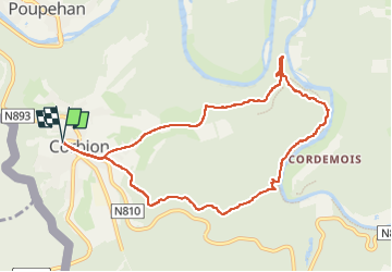
Tour Wandern von 8,8 km verfügbar auf Wallonien, Luxemburg, Bouillon. Diese Tour wird von micheldutilleul vorgeschlagen.
Beschreibung
Magnifique balade en forêt et sur les hauteurs de la Semois.
Attention, veillez prendre de bonnes chaussures de marché. Certains passages sont accidentés, voir dans l eau si la semois déborde.
Ort
Land:
Belgium
Region :
Wallonien
Abteilung/Provinz :
Luxemburg
Kommune :
Bouillon
Standort:
Unknown
Gehen Sie:(Dec)
Gehen Sie:(UTM)
644380 ; 5518080 (31U) N.
Kommentare
Touren in der Umgebung
![Tour Wandern Bouillon - RB-LUX-13 - Les belvédères bouillonnais - Photo](https://media.geolcdn.com/t/375/260/ext.jpg?maxdim=2&url=https%3A%2F%2Fservices.sitytrail.com%2FGeolivesWS%2FDownloadMedia.ashx%3FTrailID%3D179618%26Media%3Dc93ae6e1-6a5c-490e-ab2b-3f360dd3a9f8.jpg)
![Wandern Wandern](https://static1.geolcdn.com/sitytour/trail-icons/101.png)
RB-LUX-13 - Les belvédères bouillonnais
Wandern
Medium
(8)
Bouillon,
Wallonien,
Luxemburg,
Belgium
![](/images/other/stat-length.png)
20 km | 30 km-effort
5h 55min
![](https://static1.geolcdn.com/siteimages/upload/files/16400158638029165_repeat_loop_refresh_sync_direction_icon.png)
Ja
![Tour Wandern Bouillon - Marche ADEPS à Bouillon 8km500 - Photo](https://media.geolcdn.com/t/375/260/1579ffd1-b437-4fe4-a5cc-0a3a87fba898.jpg&format=jpg&maxdim=2)
![Wandern Wandern](https://static1.geolcdn.com/sitytour/trail-icons/101.png)
Marche ADEPS à Bouillon 8km500
Wandern
Schwierig
(1)
Bouillon,
Wallonien,
Luxemburg,
Belgium
![](/images/other/stat-length.png)
8,4 km | 12,5 km-effort
2h 28min
![](https://static1.geolcdn.com/siteimages/upload/files/16400158638029165_repeat_loop_refresh_sync_direction_icon.png)
Ja
![Tour Wandern Bouillon - RB-LUX-13 - Raccourci - Les belvédères bouillonnais - Photo](https://media.geolcdn.com/t/375/260/ext.jpg?maxdim=2&url=https%3A%2F%2Fservices.sitytrail.com%2FGeolivesWS%2FDownloadMedia.ashx%3FTrailID%3D216805%26Media%3Dc93ae6e1-6a5c-490e-ab2b-3f360dd3a9f8.jpg)
![Wandern Wandern](https://static1.geolcdn.com/sitytour/trail-icons/101.png)
RB-LUX-13 - Raccourci - Les belvédères bouillonnais
Wandern
Medium
(4)
Bouillon,
Wallonien,
Luxemburg,
Belgium
![](/images/other/stat-length.png)
16,7 km | 25 km-effort
4h 54min
![](https://static1.geolcdn.com/siteimages/upload/files/16400158638029165_repeat_loop_refresh_sync_direction_icon.png)
Ja
![Tour Wandern Bouillon - De Corbion à la Roche aux Eperviers - Photo](https://media.geolcdn.com/t/375/260/ext.jpg?maxdim=2&url=https%3A%2F%2Fservices.sitytrail.com%2FGeolivesWS%2FDownloadMedia.ashx%3FTrailID%3D146950%26Media%3D6d765926-55f0-4539-a611-ffe05c9bf6d8.JPG)
![Wandern Wandern](https://static1.geolcdn.com/sitytour/trail-icons/101.png)
De Corbion à la Roche aux Eperviers
Wandern
Einfach
(2)
Bouillon,
Wallonien,
Luxemburg,
Belgium
![](/images/other/stat-length.png)
10,6 km | 14,6 km-effort
2h 50min
![](https://static1.geolcdn.com/siteimages/upload/files/16400158638029165_repeat_loop_refresh_sync_direction_icon.png)
Ja
![Tour Wandern Bouillon - De Poupehan à Frahan par le sentier des crêtes - Photo](https://media.geolcdn.com/t/375/260/ext.jpg?maxdim=2&url=https%3A%2F%2Fservices.sitytrail.com%2FGeolivesWS%2FDownloadMedia.ashx%3FTrailID%3D138478%26Media%3Db86d13b9-d40b-4a52-ab60-15a552c97303.JPG)
![Wandern Wandern](https://static1.geolcdn.com/sitytour/trail-icons/101.png)
De Poupehan à Frahan par le sentier des crêtes
Wandern
Medium
(3)
Bouillon,
Wallonien,
Luxemburg,
Belgium
![](/images/other/stat-length.png)
8,8 km | 12,5 km-effort
3h 0min
![](https://static1.geolcdn.com/siteimages/upload/files/16400158638029165_repeat_loop_refresh_sync_direction_icon.png)
Ja
![Tour Wandern Bouillon - De Corbion à Poupehan par la Roche des Fées et la Chaire à Prêcher - Photo](https://media.geolcdn.com/t/375/260/ext.jpg?maxdim=2&url=https%3A%2F%2Fservices.sitytrail.com%2FGeolivesWS%2FDownloadMedia.ashx%3FTrailID%3D138476%26Media%3D05b27b25-8086-41d3-96c5-76c508b6a7d7.JPG)
![Wandern Wandern](https://static1.geolcdn.com/sitytour/trail-icons/101.png)
De Corbion à Poupehan par la Roche des Fées et la Chaire à Prêcher
Wandern
Medium
(2)
Bouillon,
Wallonien,
Luxemburg,
Belgium
![](/images/other/stat-length.png)
7,3 km | 11,1 km-effort
3h 0min
![](https://static1.geolcdn.com/siteimages/upload/files/16400158638029165_repeat_loop_refresh_sync_direction_icon.png)
Ja
![Tour Wandern Bouillon - Corbion - Le Sentier des Points de Vue - Photo](https://media.geolcdn.com/t/375/260/ext.jpg?maxdim=2&url=https%3A%2F%2Fservices.sitytrail.com%2FGeolivesWS%2FDownloadMedia.ashx%3FTrailID%3D138106%26Media%3D530b3448-4c03-4266-ae4e-a2076c332785.JPG)
![Wandern Wandern](https://static1.geolcdn.com/sitytour/trail-icons/101.png)
Corbion - Le Sentier des Points de Vue
Wandern
Medium
(7)
Bouillon,
Wallonien,
Luxemburg,
Belgium
![](/images/other/stat-length.png)
8,6 km | 12,2 km-effort
3h 0min
![](https://static1.geolcdn.com/siteimages/upload/files/16400158638029165_repeat_loop_refresh_sync_direction_icon.png)
Ja
![Tour Wandern Bouillon - Promenade vers la Passerelle de l’épine - Photo](https://media.geolcdn.com/t/375/260/a030b44f-54a7-48fb-92fc-a78ebfcb2520.jpg&format=jpg&maxdim=2)
![Wandern Wandern](https://static1.geolcdn.com/sitytour/trail-icons/101.png)
Promenade vers la Passerelle de l’épine
Wandern
Medium
(8)
Bouillon,
Wallonien,
Luxemburg,
Belgium
![](/images/other/stat-length.png)
7,3 km | 11,2 km-effort
2h 33min
![](https://static1.geolcdn.com/siteimages/upload/files/16400158638029165_repeat_loop_refresh_sync_direction_icon.png)
Ja
![Tour Wandern Bouillon - Poupehan_Rochehaut_Frahan_Poupzhan - Photo](https://media.geolcdn.com/t/375/260/0b4f111d-644c-4d33-b812-a15a1b8098b1.jpg&format=jpg&maxdim=2)
![Wandern Wandern](https://static1.geolcdn.com/sitytour/trail-icons/101.png)
Poupehan_Rochehaut_Frahan_Poupzhan
Wandern
Medium
(4)
Bouillon,
Wallonien,
Luxemburg,
Belgium
![](/images/other/stat-length.png)
12,8 km | 18,7 km-effort
5h 7min
![](https://static1.geolcdn.com/siteimages/upload/files/16400158638029165_repeat_loop_refresh_sync_direction_icon.png)
Ja