![](/images/other/stat-length.png)
![Tour Mountainbike Calès - Calès 32,7km - Photo](https://media.geolcdn.com/t/1900/400/ext.pjpeg?maxdim=2&url=https%3A%2F%2Fstatic1.geolcdn.com%2Fsiteimages%2Fupload%2Ffiles%2F1524743154velo.jpg)
Calès 32,7km
amelie14
Benutzer
![Länge](/images/other/stat-length.png)
Länge
33 km
![Maximale Höhe](https://static1.geolcdn.com/siteimages/upload/files/1508320355ic_sort_altitude_max_24dp.png)
Maximale Höhe
217 m
![Positive Höhendifferenz](https://static1.geolcdn.com/siteimages/upload/files/1508320355ic_sort_den_pos_24dp.png)
Positive Höhendifferenz
579 m
![Km-Effort](/images/other/stat-length.png)
Km-Effort
40 km
![Min. Höhe](https://static1.geolcdn.com/siteimages/upload/files/1508320355ic_sort_altitude_min_24dp.png)
Min. Höhe
44 m
![Negative Höhendifferenz](https://static1.geolcdn.com/siteimages/upload/files/1508320355ic_sort_den_neg_24dp.png)
Negative Höhendifferenz
576 m
![Boucle](https://static1.geolcdn.com/siteimages/upload/files/16400158638029165_repeat_loop_refresh_sync_direction_icon.png)
Boucle
Ja
Erstellungsdatum :
2023-01-01 12:57:09.954
Letzte Änderung :
2023-01-01 15:32:27.604
![Mountainbike](https://static1.geolcdn.com/sitytour/trail-icons/202.png)
1h45
Schwierigkeit : Medium
![Scannen Sie diesen QR-Code, um die Tour in der SityTrail-Anwendung zu öffnen](https://capi.geolives.com/qq0zvz2zws4bq2lad0pu/sitytour/trails/3500938/qr.png?size=200)
Kostenlosegpshiking-Anwendung
Über SityTrail
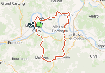
Tour Mountainbike von 33 km verfügbar auf Neu-Aquitanien, Dordogne, Calès. Diese Tour wird von amelie14 vorgeschlagen.
Beschreibung
Principalement de la route sur ce circuit (seulement une portion de chemin herbeux) où le VTT est appréciable pour le confort et le braquet dans le dénivelé positif :-)
Ort
Land:
France
Region :
Neu-Aquitanien
Abteilung/Provinz :
Dordogne
Kommune :
Calès
Standort:
Unknown
Gehen Sie:(Dec)
Gehen Sie:(UTM)
326861 ; 4969107 (31T) N.
Kommentare
Touren in der Umgebung
![Tour Wandern Badefols-sur-Dordogne - Badefols Tremola Limeuil - Photo](https://media.geolcdn.com/t/375/260/ext.jpg?maxdim=2&url=https%3A%2F%2Fservices.sitytrail.com%2FGeolivesWS%2FDownloadMedia.ashx%3FTrailID%3D268029%26Media%3D20120812110708.jpeg)
![Wandern Wandern](https://static1.geolcdn.com/sitytour/trail-icons/101.png)
Badefols Tremola Limeuil
Wandern
Einfach
Badefols-sur-Dordogne,
Neu-Aquitanien,
Dordogne,
France
![](/images/other/stat-length.png)
13,5 km | 17,9 km-effort
3h 47min
![](https://static1.geolcdn.com/siteimages/upload/files/16400158638029165_repeat_loop_refresh_sync_direction_icon.png)
Nein
![Tour Wandern Badefols-sur-Dordogne - Badefols Tremola Limeuil - Photo](https://media.geolcdn.com/t/375/260/ext.jpg?maxdim=2&url=https%3A%2F%2Fservices.sitytrail.com%2FGeolivesWS%2FDownloadMedia.ashx%3FTrailID%3D268028%26Media%3D20120812110708.jpeg)
![Wandern Wandern](https://static1.geolcdn.com/sitytour/trail-icons/101.png)
Badefols Tremola Limeuil
Wandern
Einfach
Badefols-sur-Dordogne,
Neu-Aquitanien,
Dordogne,
France
![](/images/other/stat-length.png)
13,5 km | 17,9 km-effort
3h 47min
![](https://static1.geolcdn.com/siteimages/upload/files/16400158638029165_repeat_loop_refresh_sync_direction_icon.png)
Nein
![Tour Wandern Badefols-sur-Dordogne - Badefols Tremola - Photo](https://media.geolcdn.com/t/375/260/ext.jpg?maxdim=2&url=https%3A%2F%2Fservices.sitytrail.com%2FGeolivesWS%2FDownloadMedia.ashx%3FTrailID%3D149344%26Media%3D20120812110708.jpeg)
![Wandern Wandern](https://static1.geolcdn.com/sitytour/trail-icons/101.png)
Badefols Tremola
Wandern
Einfach
Badefols-sur-Dordogne,
Neu-Aquitanien,
Dordogne,
France
![](/images/other/stat-length.png)
11,1 km | 14,4 km-effort
2h 25min
![](https://static1.geolcdn.com/siteimages/upload/files/16400158638029165_repeat_loop_refresh_sync_direction_icon.png)
Nein
![Tour Wandern Trémolat - Circuit de la Plaine à Trémolat - Photo](https://media.geolcdn.com/t/375/260/ext.jpg?maxdim=2&url=https%3A%2F%2Fservices.sitytrail.com%2FGeolivesWS%2FDownloadMedia.ashx%3FTrailID%3D111769%26Media%3D8261_6.jpg)
![Wandern Wandern](https://static1.geolcdn.com/sitytour/trail-icons/101.png)
Circuit de la Plaine à Trémolat
Wandern
Medium
(1)
Trémolat,
Neu-Aquitanien,
Dordogne,
France
![](/images/other/stat-length.png)
9,8 km | 12,1 km-effort
2h 30min
![](https://static1.geolcdn.com/siteimages/upload/files/16400158638029165_repeat_loop_refresh_sync_direction_icon.png)
Ja
![Tour Wandern Trémolat - Circuit du Cingle à Trémolat - Photo](https://media.geolcdn.com/t/375/260/ext.jpg?maxdim=2&url=https%3A%2F%2Fservices.sitytrail.com%2FGeolivesWS%2FDownloadMedia.ashx%3FTrailID%3D111768%26Media%3D8260_6.jpg)
![Wandern Wandern](https://static1.geolcdn.com/sitytour/trail-icons/101.png)
Circuit du Cingle à Trémolat
Wandern
Einfach
(3)
Trémolat,
Neu-Aquitanien,
Dordogne,
France
![](/images/other/stat-length.png)
6,7 km | 9 km-effort
1h 45min
![](https://static1.geolcdn.com/siteimages/upload/files/16400158638029165_repeat_loop_refresh_sync_direction_icon.png)
Ja
![Tour Wandern Mauzac-et-Grand-Castang - Mauzac 12,7km - Photo](https://media.geolcdn.com/t/375/260/023dbbf0-6b65-4613-beb1-cfd2b475d490.jpg&format=jpg&maxdim=2)
![Wandern Wandern](https://static1.geolcdn.com/sitytour/trail-icons/101.png)
Mauzac 12,7km
Wandern
Medium
Mauzac-et-Grand-Castang,
Neu-Aquitanien,
Dordogne,
France
![](/images/other/stat-length.png)
12,6 km | 16,5 km-effort
2h 26min
![](https://static1.geolcdn.com/siteimages/upload/files/16400158638029165_repeat_loop_refresh_sync_direction_icon.png)
Ja
![Tour Wandern Le Buisson-de-Cadouin - Cadouin 12km - Photo](https://media.geolcdn.com/t/375/260/120dde7b-1d04-430e-8ec0-3a35e81f3f18.jpg&format=jpg&maxdim=2)
![Wandern Wandern](https://static1.geolcdn.com/sitytour/trail-icons/101.png)
Cadouin 12km
Wandern
Medium
Le Buisson-de-Cadouin,
Neu-Aquitanien,
Dordogne,
France
![](/images/other/stat-length.png)
12,1 km | 15,5 km-effort
2h 21min
![](https://static1.geolcdn.com/siteimages/upload/files/16400158638029165_repeat_loop_refresh_sync_direction_icon.png)
Ja
![Tour Wandern Mauzac-et-Grand-Castang - Mauzac 17,4km - Photo](https://media.geolcdn.com/t/375/260/a3463154-ced4-4d16-b9fc-830141fb7f18.jpg&format=jpg&maxdim=2)
![Wandern Wandern](https://static1.geolcdn.com/sitytour/trail-icons/101.png)
Mauzac 17,4km
Wandern
Medium
Mauzac-et-Grand-Castang,
Neu-Aquitanien,
Dordogne,
France
![](/images/other/stat-length.png)
17,4 km | 22 km-effort
4h 4min
![](https://static1.geolcdn.com/siteimages/upload/files/16400158638029165_repeat_loop_refresh_sync_direction_icon.png)
Ja
![Tour Wandern Lalinde - Sauveboeuf 14,4km - Photo](https://media.geolcdn.com/t/375/260/57bad7d6-cdc8-49af-853c-05939ee56322.jpg&format=jpg&maxdim=2)
![Wandern Wandern](https://static1.geolcdn.com/sitytour/trail-icons/101.png)
Sauveboeuf 14,4km
Wandern
Medium
Lalinde,
Neu-Aquitanien,
Dordogne,
France
![](/images/other/stat-length.png)
14,4 km | 18,1 km-effort
2h 49min
![](https://static1.geolcdn.com/siteimages/upload/files/16400158638029165_repeat_loop_refresh_sync_direction_icon.png)
Ja