![](/images/other/stat-length.png)
![Tour Wandern Habich - Découvrir-Apprécier la nature 2ème partie (2022) - Photo](https://media.geolcdn.com/t/1900/400/d947ae3b-c4af-4f76-ab83-7cc5bb1df906.jpg&format=pjpeg&maxdim=2)
Découvrir-Apprécier la nature 2ème partie (2022)
yop236
Benutzer
![Länge](/images/other/stat-length.png)
Länge
6,4 km
![Maximale Höhe](https://static1.geolcdn.com/siteimages/upload/files/1508320355ic_sort_altitude_max_24dp.png)
Maximale Höhe
424 m
![Positive Höhendifferenz](https://static1.geolcdn.com/siteimages/upload/files/1508320355ic_sort_den_pos_24dp.png)
Positive Höhendifferenz
104 m
![Km-Effort](/images/other/stat-length.png)
Km-Effort
7,8 km
![Min. Höhe](https://static1.geolcdn.com/siteimages/upload/files/1508320355ic_sort_altitude_min_24dp.png)
Min. Höhe
373 m
![Negative Höhendifferenz](https://static1.geolcdn.com/siteimages/upload/files/1508320355ic_sort_den_neg_24dp.png)
Negative Höhendifferenz
105 m
![Boucle](https://static1.geolcdn.com/siteimages/upload/files/16400158638029165_repeat_loop_refresh_sync_direction_icon.png)
Boucle
Ja
Erstellungsdatum :
2022-12-30 15:03:00.529
Letzte Änderung :
2022-12-30 15:13:35.133
![Wandern](https://static1.geolcdn.com/sitytour/trail-icons/101.png)
1h45
Schwierigkeit : Medium
![Scannen Sie diesen QR-Code, um die Tour in der SityTrail-Anwendung zu öffnen](https://capi.geolives.com/qq0zvz2zws4bq2lad0pu/sitytour/trails/3498158/qr.png?size=200)
Kostenlosegpshiking-Anwendung
Über SityTrail
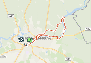
Tour Wandern von 6,4 km verfügbar auf Wallonien, Luxemburg, Habich. Diese Tour wird von yop236 vorgeschlagen.
Beschreibung
Balade balisée en boucle au départ de Habay-la-Neuve, Place P Nothomb.
Découvrir Habay-la-Neuve jusqu'au domaine du Pont d'Oye.
Ort
Land:
Belgium
Region :
Wallonien
Abteilung/Provinz :
Luxemburg
Kommune :
Habich
Standort:
Habay-la-Neuve
Gehen Sie:(Dec)
Gehen Sie:(UTM)
690642 ; 5511708 (31U) N.
Kommentare
Touren in der Umgebung
![Tour Wandern Habich - RB-LUX-11 - Au coeur de la forêt d’Anlier - Photo](https://media.geolcdn.com/t/375/260/ext.jpg?maxdim=2&url=https%3A%2F%2Fservices.sitytrail.com%2FGeolivesWS%2FDownloadMedia.ashx%3FTrailID%3D179616%26Media%3D08af71d9-c674-44b1-8950-c42d6cbce43a.jpg)
![Wandern Wandern](https://static1.geolcdn.com/sitytour/trail-icons/101.png)
RB-LUX-11 - Au coeur de la forêt d’Anlier
Wandern
Schwierig
(8)
Habich,
Wallonien,
Luxemburg,
Belgium
![](/images/other/stat-length.png)
23 km | 29 km-effort
5h 56min
![](https://static1.geolcdn.com/siteimages/upload/files/16400158638029165_repeat_loop_refresh_sync_direction_icon.png)
Ja
![Tour Reiten Habich - Forêt de Rulles - Photo](https://media.geolcdn.com/t/375/260/a38a8cb1-ff9c-4914-bcb7-5d901a1c22cc.jpg&format=jpg&maxdim=2)
![Reiten Reiten](https://static1.geolcdn.com/sitytour/trail-icons/301.png)
Forêt de Rulles
Reiten
Einfach
(1)
Habich,
Wallonien,
Luxemburg,
Belgium
![](/images/other/stat-length.png)
12,5 km | 15,3 km-effort
1h 56min
![](https://static1.geolcdn.com/siteimages/upload/files/16400158638029165_repeat_loop_refresh_sync_direction_icon.png)
Ja
![Tour Fahrrad Habich - Balade du patrimoine - Photo](https://media.geolcdn.com/t/375/260/ext.jpg?maxdim=2&url=https%3A%2F%2Fservices.sitytrail.com%2FGeolivesWS%2FDownloadMedia.ashx%3FTrailID%3D619592%26Media%3Dfix__20160823152423.jpg)
![Fahrrad Fahrrad](https://static1.geolcdn.com/sitytour/trail-icons/200.png)
Balade du patrimoine
Fahrrad
Einfach
(1)
Habich,
Wallonien,
Luxemburg,
Belgium
![](/images/other/stat-length.png)
23 km | 28 km-effort
1h 36min
![](https://static1.geolcdn.com/siteimages/upload/files/16400158638029165_repeat_loop_refresh_sync_direction_icon.png)
Ja
![Tour Pferd Habich - Etang du Châtelet - Photo](https://media.geolcdn.com/t/375/260/ext.jpg?maxdim=2&url=https%3A%2F%2Fservices.sitytrail.com%2FGeolivesWS%2FDownloadMedia.ashx%3FTrailID%3D449819%26Media%3Dfix__20141207155625.jpg)
![Pferd Pferd](https://static1.geolcdn.com/sitytour/trail-icons/300.png)
Etang du Châtelet
Pferd
Medium
(1)
Habich,
Wallonien,
Luxemburg,
Belgium
![](/images/other/stat-length.png)
11 km | 13,6 km-effort
1h 43min
![](https://static1.geolcdn.com/siteimages/upload/files/16400158638029165_repeat_loop_refresh_sync_direction_icon.png)
Ja
![Tour Wandern Habich - RB-LUX-11 - Raccourci - Au coeur de la forêt d’Anlier - Photo](https://media.geolcdn.com/t/375/260/ext.jpg?maxdim=2&url=https%3A%2F%2Fservices.sitytrail.com%2FGeolivesWS%2FDownloadMedia.ashx%3FTrailID%3D216796%26Media%3D7c022f6c-85e7-4bd4-8bf7-3a772296d0f7.jpg)
![Wandern Wandern](https://static1.geolcdn.com/sitytour/trail-icons/101.png)
RB-LUX-11 - Raccourci - Au coeur de la forêt d’Anlier
Wandern
Einfach
(1)
Habich,
Wallonien,
Luxemburg,
Belgium
![](/images/other/stat-length.png)
14,5 km | 18,5 km-effort
3h 55min
![](https://static1.geolcdn.com/siteimages/upload/files/16400158638029165_repeat_loop_refresh_sync_direction_icon.png)
Ja
![Tour Wandern Étalle - Sentier des mardelles - Photo](https://media.geolcdn.com/t/375/260/ext.jpg?maxdim=2&url=https%3A%2F%2Fservices.sitytrail.com%2FGeolivesWS%2FDownloadMedia.ashx%3FTrailID%3D67799%26Media%3D7cf7391b-4ead-4d15-8bef-379f53159afc.JPG)
![Wandern Wandern](https://static1.geolcdn.com/sitytour/trail-icons/101.png)
Sentier des mardelles
Wandern
Einfach
(1)
Étalle,
Wallonien,
Luxemburg,
Belgium
![](/images/other/stat-length.png)
3,7 km | 4,2 km-effort
1h 0min
![](https://static1.geolcdn.com/siteimages/upload/files/16400158638029165_repeat_loop_refresh_sync_direction_icon.png)
Ja
![Mountainbike Mountainbike](https://static1.geolcdn.com/sitytour/trail-icons/202.png)
forêt d Anlier
Mountainbike
Einfach
(1)
Habich,
Wallonien,
Luxemburg,
Belgium
![](/images/other/stat-length.png)
28 km | 34 km-effort
2h 43min
![](https://static1.geolcdn.com/siteimages/upload/files/16400158638029165_repeat_loop_refresh_sync_direction_icon.png)
Ja
![Tour Andere Aktivitäten Attert - Nobressart-Burgknapp - Photo](https://media.geolcdn.com/t/375/260/ext.jpg?maxdim=2&url=https%3A%2F%2Fservices.sitytrail.com%2FGeolivesWS%2FDownloadMedia.ashx%3FTrailID%3D855557%26Media%3D20171101150204.jpg)
![Andere Aktivitäten Andere Aktivitäten](https://static1.geolcdn.com/sitytour/trail-icons/900.png)
Nobressart-Burgknapp
Andere Aktivitäten
Sehr leicht
(1)
Attert,
Wallonien,
Luxemburg,
Belgium
![](/images/other/stat-length.png)
7,1 km | 9,1 km-effort
2h 42min
![](https://static1.geolcdn.com/siteimages/upload/files/16400158638029165_repeat_loop_refresh_sync_direction_icon.png)
Ja
![Tour Wandern Habich - Fagne Jean-Simon (version longue) - Photo](https://media.geolcdn.com/t/375/260/ext.jpg?maxdim=2&url=https%3A%2F%2Fservices.sitytrail.com%2FGeolivesWS%2FDownloadMedia.ashx%3FTrailID%3D412594%26Media%3Dfix__20150426151407.jpg)
![Wandern Wandern](https://static1.geolcdn.com/sitytour/trail-icons/101.png)
Fagne Jean-Simon (version longue)
Wandern
Einfach
(1)
Habich,
Wallonien,
Luxemburg,
Belgium
![](/images/other/stat-length.png)
11,1 km | 13,7 km-effort
3h 0min
![](https://static1.geolcdn.com/siteimages/upload/files/16400158638029165_repeat_loop_refresh_sync_direction_icon.png)
Ja