![](/images/other/stat-length.png)
![Tour Wandern Paroy - paroy - Photo](https://media.geolcdn.com/t/1900/400/378ec14a-d696-40da-bfca-933f8dfdc99c.jpg&format=pjpeg&maxdim=2)
paroy
eltonnermou
Benutzer
![Länge](/images/other/stat-length.png)
![Maximale Höhe](https://static1.geolcdn.com/siteimages/upload/files/1508320355ic_sort_altitude_max_24dp.png)
![Positive Höhendifferenz](https://static1.geolcdn.com/siteimages/upload/files/1508320355ic_sort_den_pos_24dp.png)
![Km-Effort](/images/other/stat-length.png)
![Min. Höhe](https://static1.geolcdn.com/siteimages/upload/files/1508320355ic_sort_altitude_min_24dp.png)
![Negative Höhendifferenz](https://static1.geolcdn.com/siteimages/upload/files/1508320355ic_sort_den_neg_24dp.png)
![Boucle](https://static1.geolcdn.com/siteimages/upload/files/16400158638029165_repeat_loop_refresh_sync_direction_icon.png)
![Wandern](https://static1.geolcdn.com/sitytour/trail-icons/101.png)
3h08
Schwierigkeit : Medium
![Scannen Sie diesen QR-Code, um die Tour in der SityTrail-Anwendung zu öffnen](https://capi.geolives.com/qq0zvz2zws4bq2lad0pu/sitytour/trails/3490796/qr.png?size=200)
Kostenlosegpshiking-Anwendung
Über SityTrail
Tour Wandern von 18,4 km verfügbar auf Burgund und Freigrafschaft, Doubs, Paroy. Diese Tour wird von eltonnermou vorgeschlagen.
Beschreibung
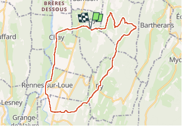
parking terrain de foot rue marronniers
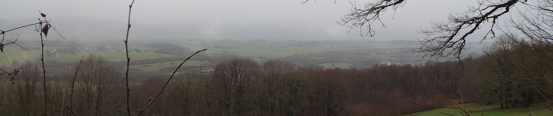
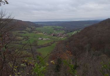
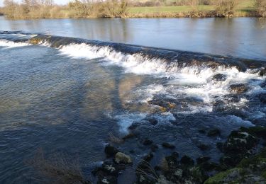
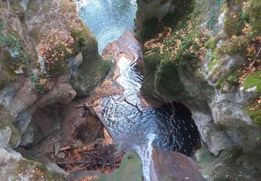
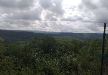
Belle randonnée avec de beaux points de vue (faites le détour au belvédère de Ronchaux) sur la vallée de la Loue. Dans le sens de la marche vous trouverez des tables à 8,6km pour votre pic-nique.
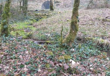
Dans ces espaces escarpés laissez vous surprendre par la faune sauvage (chamois, chevreuil, ...). Petit bémol, beaucoup trop de goudron (et pas assez de plumes) à mon goût.
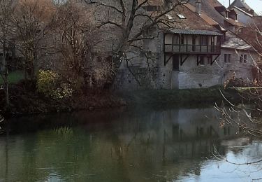
Attention par crue de la Loue, le cheminement entre Rennes et Chay peut être rendu impossible !!!
Ort
Kommentare
Touren in der Umgebung
![Tour Wandern Échay - echay et ses belvédères - Photo](https://media.geolcdn.com/t/375/260/e9128b6b-1c37-4aeb-a422-222156e2fff2.jpg&format=jpg&maxdim=2)
![Wandern Wandern](https://static1.geolcdn.com/sitytour/trail-icons/101.png)
Wandern
![](/images/other/stat-length.png)
![](https://static1.geolcdn.com/siteimages/upload/files/16400158638029165_repeat_loop_refresh_sync_direction_icon.png)
![Tour Wandern Lombard - Lombard - Photo](https://media.geolcdn.com/t/375/260/b115cf83-3571-419e-9898-67fe86dca798.jpg&format=jpg&maxdim=2)
![Wandern Wandern](https://static1.geolcdn.com/sitytour/trail-icons/101.png)
Wandern
![](/images/other/stat-length.png)
![](https://static1.geolcdn.com/siteimages/upload/files/16400158638029165_repeat_loop_refresh_sync_direction_icon.png)
![Tour Wandern Myon - myon les lunettes à Stéphane - Photo](https://media.geolcdn.com/t/375/260/25acafcd-fd37-4522-a9e0-f3895665c873.jpg&format=jpg&maxdim=2)
![Wandern Wandern](https://static1.geolcdn.com/sitytour/trail-icons/101.png)
Wandern
![](/images/other/stat-length.png)
![](https://static1.geolcdn.com/siteimages/upload/files/16400158638029165_repeat_loop_refresh_sync_direction_icon.png)
![Tour Wandern Rennes-sur-Loue - Rennes sur Loue - Photo](https://media.geolcdn.com/t/375/260/eb24f96c-dd7d-40a0-a849-4c5b681e042a.jpg&format=jpg&maxdim=2)
![Wandern Wandern](https://static1.geolcdn.com/sitytour/trail-icons/101.png)
Wandern
![](/images/other/stat-length.png)
![](https://static1.geolcdn.com/siteimages/upload/files/16400158638029165_repeat_loop_refresh_sync_direction_icon.png)
![Tour Wandern Myon - Myon le gour de conche - Photo](https://media.geolcdn.com/t/375/260/828466b3-4a5a-411c-b191-55f6e34400fe.jpg&format=jpg&maxdim=2)
![Wandern Wandern](https://static1.geolcdn.com/sitytour/trail-icons/101.png)
Wandern
![](/images/other/stat-length.png)
![](https://static1.geolcdn.com/siteimages/upload/files/16400158638029165_repeat_loop_refresh_sync_direction_icon.png)
![Tour Wandern Myon - Myon 3 collines - Photo](https://media.geolcdn.com/t/375/260/d4f8bb66-121f-460c-987f-bea11d25d8d0.jpg&format=jpg&maxdim=2)
![Wandern Wandern](https://static1.geolcdn.com/sitytour/trail-icons/101.png)
Wandern
![](/images/other/stat-length.png)
![](https://static1.geolcdn.com/siteimages/upload/files/16400158638029165_repeat_loop_refresh_sync_direction_icon.png)
![Tour Wandern Myon - Myon - Photo](https://media.geolcdn.com/t/375/260/e011c131-f78b-4966-a193-682c39bb3a11.jpg&format=jpg&maxdim=2)
![Wandern Wandern](https://static1.geolcdn.com/sitytour/trail-icons/101.png)
Wandern
![](/images/other/stat-length.png)
![](https://static1.geolcdn.com/siteimages/upload/files/16400158638029165_repeat_loop_refresh_sync_direction_icon.png)
![Tour Zu Fuß Port-Lesney - Chemin des Gabelous - Photo](https://media.geolcdn.com/t/375/260/09807b3d-6dc5-4f94-a372-f894abc0bac2.jpeg&format=jpg&maxdim=2)
![Zu Fuß Zu Fuß](https://static1.geolcdn.com/sitytour/trail-icons/100.png)
Zu Fuß
![](/images/other/stat-length.png)
![](https://static1.geolcdn.com/siteimages/upload/files/16400158638029165_repeat_loop_refresh_sync_direction_icon.png)
![Tour Wandern Port-Lesney - Vaulgrenan depuis Port Lesney. - Photo](https://media.geolcdn.com/t/375/260/888b9e37-2427-47c6-a53b-dfa1373cf9fa.jpg&format=jpg&maxdim=2)
![Wandern Wandern](https://static1.geolcdn.com/sitytour/trail-icons/101.png)
Wandern
![](/images/other/stat-length.png)
![](https://static1.geolcdn.com/siteimages/upload/files/16400158638029165_repeat_loop_refresh_sync_direction_icon.png)