![](/images/other/stat-length.png)
![Tour Wandern Moustiers-Sainte-Marie - Moustier saine Marie 11,4 km - Photo](https://media.geolcdn.com/t/1900/400/325a0dcc-1ff8-4d2c-a406-91140305788f.jpeg&format=pjpeg&maxdim=2)
Moustier saine Marie 11,4 km
rvapeldo
Benutzer GUIDE
![Länge](/images/other/stat-length.png)
![Maximale Höhe](https://static1.geolcdn.com/siteimages/upload/files/1508320355ic_sort_altitude_max_24dp.png)
![Positive Höhendifferenz](https://static1.geolcdn.com/siteimages/upload/files/1508320355ic_sort_den_pos_24dp.png)
![Km-Effort](/images/other/stat-length.png)
![Min. Höhe](https://static1.geolcdn.com/siteimages/upload/files/1508320355ic_sort_altitude_min_24dp.png)
![Negative Höhendifferenz](https://static1.geolcdn.com/siteimages/upload/files/1508320355ic_sort_den_neg_24dp.png)
![Boucle](https://static1.geolcdn.com/siteimages/upload/files/16400158638029165_repeat_loop_refresh_sync_direction_icon.png)
![Wandern](https://static1.geolcdn.com/sitytour/trail-icons/101.png)
4h16
Schwierigkeit : Medium
![Scannen Sie diesen QR-Code, um die Tour in der SityTrail-Anwendung zu öffnen](https://capi.geolives.com/qq0zvz2zws4bq2lad0pu/sitytour/trails/3481118/qr.png?size=200)
Kostenlosegpshiking-Anwendung
Über SityTrail
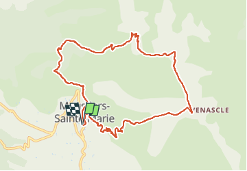
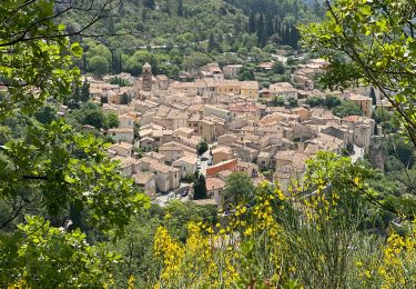
Tour Wandern von 11,4 km verfügbar auf Provence-Alpes-Côte d'Azur, Alpes-de-Haute-Provence, Moustiers-Sainte-Marie. Diese Tour wird von rvapeldo vorgeschlagen.
Beschreibung
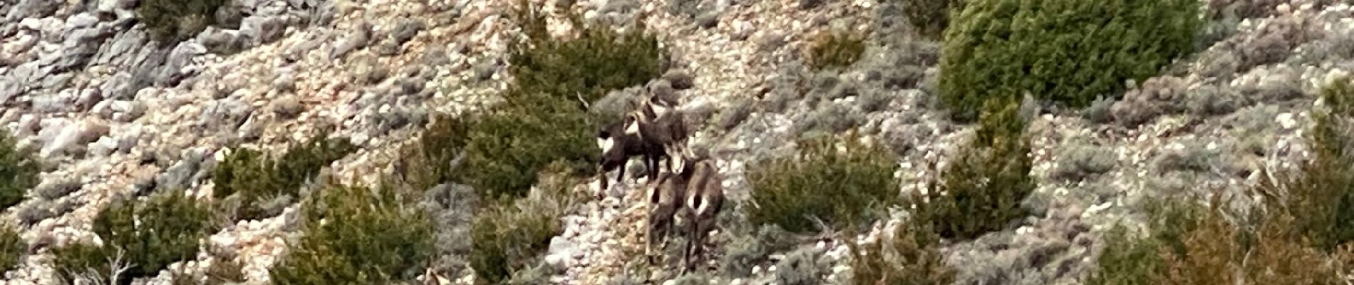
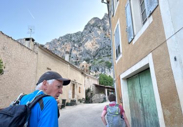
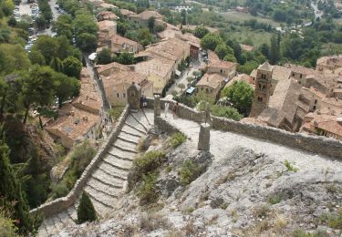
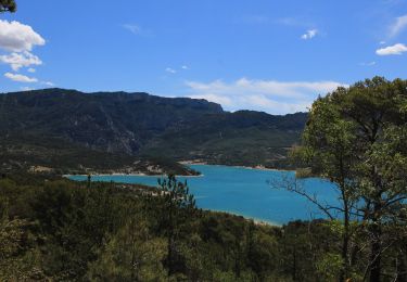
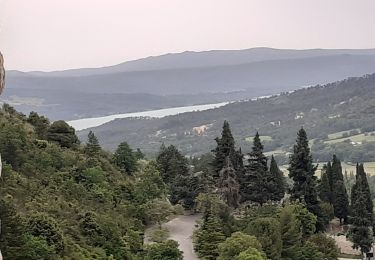
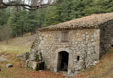
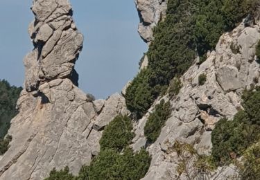
Balade classique au départ de Moustier Ste Marie, d’une grosse dizaine de kilomètres, réalisée en décembre 2022 (temps gris avec éclaircies). Elle démarre par une montée tranquille une fois franchie la porte d’un ancien rempart. Arrivé à environ 900/950 mètres d’altitude (Moustier est à 600 m), le paysage est dégagé, le parcours franchi le ravin du Riou, le cours d’eau qui traverse Moustier (passage à gué). A certains moments la vue s’étend vers le lac Sainte-Croix. La partie le plus spectaculaire est la route romaine (Courchon) qui descend en zig zag sur le village de départ, et offre une vue panoramique sur les environs. Pas de difficulté particulière mais les chemins sont parfois fort caillouteux, il vaut mieux regarder où l’on pose le pied (bonnes chaussures recommandées). Il y a moyen de voir des chamois et d’admirer des rapaces planant dans les airs. Très jolie randonnée. Je n’ai rencontré personne mais en été il doit y avoir du monde dans le coin (puis ça doit bien chauffer). Comptez 4h (un peu plus si pique nique en route).
Ort
Kommentare
Touren in der Umgebung
![Tour Wandern Moustiers-Sainte-Marie - Tour des Gorges du Verdon - Photo](https://media.geolcdn.com/t/375/260/ext.jpg?maxdim=2&url=https%3A%2F%2Fstatic1.geolcdn.com%2Fsiteimages%2Fupload%2Ffiles%2F1553511878bg_sport_marche.png)
![Wandern Wandern](https://static1.geolcdn.com/sitytour/trail-icons/101.png)
Wandern
![](/images/other/stat-length.png)
![](https://static1.geolcdn.com/siteimages/upload/files/16400158638029165_repeat_loop_refresh_sync_direction_icon.png)
![Tour Wandern Moustiers-Sainte-Marie - Moustier Ravin Notre Dame crête de l’Ourbes 14,5 km - Photo](https://media.geolcdn.com/t/375/260/a74da90b-306e-4ee3-bd53-9babe310e6e2.jpg&format=jpg&maxdim=2)
![Wandern Wandern](https://static1.geolcdn.com/sitytour/trail-icons/101.png)
Wandern
![](/images/other/stat-length.png)
![](https://static1.geolcdn.com/siteimages/upload/files/16400158638029165_repeat_loop_refresh_sync_direction_icon.png)
![Tour Wandern Moustiers-Sainte-Marie - 2023-02-14 Les grottes de Saint Maurin - Photo](https://media.geolcdn.com/t/375/260/ff240215-b004-40c4-b632-ab00d837cb62.jpg&format=jpg&maxdim=2)
![Wandern Wandern](https://static1.geolcdn.com/sitytour/trail-icons/101.png)
Wandern
![](/images/other/stat-length.png)
![](https://static1.geolcdn.com/siteimages/upload/files/16400158638029165_repeat_loop_refresh_sync_direction_icon.png)
![Tour Wandern Moustiers-Sainte-Marie - Moutiers Sainte Marie - Voie Romaine vers Vénascle - Photo](https://media.geolcdn.com/t/375/260/f43e62cf-b80e-49c9-83f1-1f2cdcff5d1b.jpg&format=jpg&maxdim=2)
![Wandern Wandern](https://static1.geolcdn.com/sitytour/trail-icons/101.png)
Wandern
![](/images/other/stat-length.png)
![](https://static1.geolcdn.com/siteimages/upload/files/16400158638029165_repeat_loop_refresh_sync_direction_icon.png)
![Tour Wandern Moustiers-Sainte-Marie - Autour de Moustiers st Marie - Photo](https://media.geolcdn.com/t/375/260/ext.jpg?maxdim=2&url=https%3A%2F%2Fservices.sitytrail.com%2FGeolivesWS%2FDownloadMedia.ashx%3FTrailID%3D820131%26Media%3D24900497-3777-4a34-815d-aa485e7dbccc.JPG)
![Wandern Wandern](https://static1.geolcdn.com/sitytour/trail-icons/101.png)
Wandern
![](/images/other/stat-length.png)
![](https://static1.geolcdn.com/siteimages/upload/files/16400158638029165_repeat_loop_refresh_sync_direction_icon.png)
![Tour Wandern Moustiers-Sainte-Marie - moustiers ste Marie - Photo](https://media.geolcdn.com/t/375/260/91116718-bfd8-4bd6-8abb-af72a3de0c85.jpg&format=jpg&maxdim=2)
![Wandern Wandern](https://static1.geolcdn.com/sitytour/trail-icons/101.png)
Wandern
![](/images/other/stat-length.png)
![](https://static1.geolcdn.com/siteimages/upload/files/16400158638029165_repeat_loop_refresh_sync_direction_icon.png)
![Tour Wandern Moustiers-Sainte-Marie - moustier mont deniers 18k 100m - Photo](https://media.geolcdn.com/t/375/260/8ddff121-5caf-44e2-ae18-5659b34b6078.jpg&format=jpg&maxdim=2)
![Wandern Wandern](https://static1.geolcdn.com/sitytour/trail-icons/101.png)
Wandern
![](/images/other/stat-length.png)
![](https://static1.geolcdn.com/siteimages/upload/files/16400158638029165_repeat_loop_refresh_sync_direction_icon.png)
![Tour Wandern Moustiers-Sainte-Marie - 2023-10-03 Naverre-Cascade du Riou-Marignol - Photo](https://media.geolcdn.com/t/375/260/cca55c37-c9d5-4f62-8c9c-de8910f158bb.jpg&format=jpg&maxdim=2)
![Wandern Wandern](https://static1.geolcdn.com/sitytour/trail-icons/101.png)
Wandern
![](/images/other/stat-length.png)
![](https://static1.geolcdn.com/siteimages/upload/files/16400158638029165_repeat_loop_refresh_sync_direction_icon.png)
![Tour Wandern Moustiers-Sainte-Marie - Moustiers Castillon 13,1 km - Photo](https://media.geolcdn.com/t/375/260/67d7caf9-1103-4311-aaa1-f3ca261dd5d8.jpg&format=jpg&maxdim=2)
![Wandern Wandern](https://static1.geolcdn.com/sitytour/trail-icons/101.png)
Wandern
![](/images/other/stat-length.png)
![](https://static1.geolcdn.com/siteimages/upload/files/16400158638029165_repeat_loop_refresh_sync_direction_icon.png)