![](/images/other/stat-length.png)
![Tour Wandern Peyrins - Bois des Ussiaux- Gues du Chalon - Photo](https://media.geolcdn.com/t/1900/400/ext.pjpeg?maxdim=2&url=https%3A%2F%2Fstatic1.geolcdn.com%2Fsiteimages%2Fupload%2Ffiles%2F1553511878bg_sport_marche.png)
Bois des Ussiaux- Gues du Chalon
meillon
Benutzer
![Länge](/images/other/stat-length.png)
Länge
19,9 km
![Maximale Höhe](https://static1.geolcdn.com/siteimages/upload/files/1508320355ic_sort_altitude_max_24dp.png)
Maximale Höhe
353 m
![Positive Höhendifferenz](https://static1.geolcdn.com/siteimages/upload/files/1508320355ic_sort_den_pos_24dp.png)
Positive Höhendifferenz
298 m
![Km-Effort](/images/other/stat-length.png)
Km-Effort
24 km
![Min. Höhe](https://static1.geolcdn.com/siteimages/upload/files/1508320355ic_sort_altitude_min_24dp.png)
Min. Höhe
157 m
![Negative Höhendifferenz](https://static1.geolcdn.com/siteimages/upload/files/1508320355ic_sort_den_neg_24dp.png)
Negative Höhendifferenz
379 m
![Boucle](https://static1.geolcdn.com/siteimages/upload/files/16400158638029165_repeat_loop_refresh_sync_direction_icon.png)
Boucle
Nein
Erstellungsdatum :
2022-12-10 14:10:38.687
Letzte Änderung :
2022-12-10 17:11:54.077
![Wandern](https://static1.geolcdn.com/sitytour/trail-icons/101.png)
3h00
Schwierigkeit : Einfach
![Scannen Sie diesen QR-Code, um die Tour in der SityTrail-Anwendung zu öffnen](https://capi.geolives.com/qq0zvz2zws4bq2lad0pu/sitytour/trails/3478344/qr.png?size=200)
Kostenlosegpshiking-Anwendung
Über SityTrail
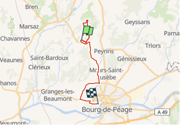
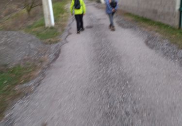
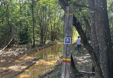
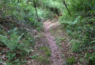
Tour Wandern von 19,9 km verfügbar auf Auvergne-Rhone-Alpen, Drôme, Peyrins. Diese Tour wird von meillon vorgeschlagen.
Beschreibung
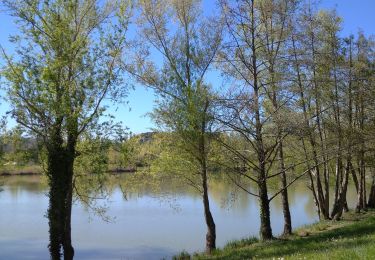
A partir du parking du bois des Ussiaux parcours Sylvestre en U vers les gues du Chalon aller et retour...sympa mais en hiver on se trempé les pieds dans le cœur non à sec...
Ort
Land:
France
Region :
Auvergne-Rhone-Alpen
Abteilung/Provinz :
Drôme
Kommune :
Peyrins
Standort:
Unknown
Gehen Sie:(Dec)
Gehen Sie:(UTM)
658631 ; 4996142 (31T) N.
Kommentare
Touren in der Umgebung
![Tour Wandern Romans-sur-Isère - Les Balmes - Photo](https://media.geolcdn.com/t/375/260/ext.jpg?maxdim=2&url=https%3A%2F%2Fstatic1.geolcdn.com%2Fsiteimages%2Fupload%2Ffiles%2F1553511878bg_sport_marche.png)
![Wandern Wandern](https://static1.geolcdn.com/sitytour/trail-icons/101.png)
Les Balmes
Wandern
Einfach
(1)
Romans-sur-Isère,
Auvergne-Rhone-Alpen,
Drôme,
France
![](/images/other/stat-length.png)
6,7 km | 8,4 km-effort
1h 55min
![](https://static1.geolcdn.com/siteimages/upload/files/16400158638029165_repeat_loop_refresh_sync_direction_icon.png)
Ja
![Tour Wandern Romans-sur-Isère - Pourtour dans les Balmes - Photo](https://media.geolcdn.com/t/375/260/ext.jpg?maxdim=2&url=https%3A%2F%2Fstatic1.geolcdn.com%2Fsiteimages%2Fupload%2Ffiles%2F1553511878bg_sport_marche.png)
![Wandern Wandern](https://static1.geolcdn.com/sitytour/trail-icons/101.png)
Pourtour dans les Balmes
Wandern
Einfach
(2)
Romans-sur-Isère,
Auvergne-Rhone-Alpen,
Drôme,
France
![](/images/other/stat-length.png)
7,5 km | 9,4 km-effort
2h 19min
![](https://static1.geolcdn.com/siteimages/upload/files/16400158638029165_repeat_loop_refresh_sync_direction_icon.png)
Ja
![Tour Wandern Clérieux - 26 clerieux st bardoux - Photo](https://media.geolcdn.com/t/375/260/cb2451d8-4be4-4eb7-ad8b-19289b8e149f.jpg&format=jpg&maxdim=2)
![Wandern Wandern](https://static1.geolcdn.com/sitytour/trail-icons/101.png)
26 clerieux st bardoux
Wandern
Einfach
Clérieux,
Auvergne-Rhone-Alpen,
Drôme,
France
![](/images/other/stat-length.png)
12,7 km | 16,1 km-effort
3h 16min
![](https://static1.geolcdn.com/siteimages/upload/files/16400158638029165_repeat_loop_refresh_sync_direction_icon.png)
Nein
![Tour Wandern Arthémonay - Reculais 06 2024 - Photo](https://media.geolcdn.com/t/375/260/bb303910-b4b2-4d55-a4d3-11e9446d4fdb.jpg&format=jpg&maxdim=2)
![Wandern Wandern](https://static1.geolcdn.com/sitytour/trail-icons/101.png)
Reculais 06 2024
Wandern
Schwierig
Arthémonay,
Auvergne-Rhone-Alpen,
Drôme,
France
![](/images/other/stat-length.png)
11,7 km | 15,6 km-effort
3h 33min
![](https://static1.geolcdn.com/siteimages/upload/files/16400158638029165_repeat_loop_refresh_sync_direction_icon.png)
Ja
![Tour Wandern Saint-Bardoux - 26 st bardoux - Photo](https://media.geolcdn.com/t/375/260/c6008a2f-fee4-4474-b4e7-42a6de67bb8a.jpg&format=jpg&maxdim=2)
![Wandern Wandern](https://static1.geolcdn.com/sitytour/trail-icons/101.png)
26 st bardoux
Wandern
Einfach
Saint-Bardoux,
Auvergne-Rhone-Alpen,
Drôme,
France
![](/images/other/stat-length.png)
21 km | 28 km-effort
6h 2min
![](https://static1.geolcdn.com/siteimages/upload/files/16400158638029165_repeat_loop_refresh_sync_direction_icon.png)
Ja
![Tour Wandern Saint-Donat-sur-l'Herbasse - 26 st donat sizay 18 04 2021 - Photo](https://media.geolcdn.com/t/375/260/fa2afb1e-c323-4ed6-b995-4570b7209fea.jpg&format=jpg&maxdim=2)
![Wandern Wandern](https://static1.geolcdn.com/sitytour/trail-icons/101.png)
26 st donat sizay 18 04 2021
Wandern
Einfach
Saint-Donat-sur-l'Herbasse,
Auvergne-Rhone-Alpen,
Drôme,
France
![](/images/other/stat-length.png)
19,9 km | 26 km-effort
6h 20min
![](https://static1.geolcdn.com/siteimages/upload/files/16400158638029165_repeat_loop_refresh_sync_direction_icon.png)
Nein
![Tour Wandern Peyrins - 26 peyrins 08 05 2021 - Photo](https://media.geolcdn.com/t/375/260/8c6a4f14-e0a7-400c-9034-00981b4cb101.jpg&format=jpg&maxdim=2)
![Wandern Wandern](https://static1.geolcdn.com/sitytour/trail-icons/101.png)
26 peyrins 08 05 2021
Wandern
Einfach
Peyrins,
Auvergne-Rhone-Alpen,
Drôme,
France
![](/images/other/stat-length.png)
18,3 km | 25 km-effort
6h 28min
![](https://static1.geolcdn.com/siteimages/upload/files/16400158638029165_repeat_loop_refresh_sync_direction_icon.png)
Ja
![Tour Wandern Saint-Donat-sur-l'Herbasse - lac de champos bois de sizay - Photo](https://media.geolcdn.com/t/375/260/ext.jpg?maxdim=2&url=https%3A%2F%2Fstatic1.geolcdn.com%2Fsiteimages%2Fupload%2Ffiles%2F1553511878bg_sport_marche.png)
![Wandern Wandern](https://static1.geolcdn.com/sitytour/trail-icons/101.png)
lac de champos bois de sizay
Wandern
Sehr leicht
(1)
Saint-Donat-sur-l'Herbasse,
Auvergne-Rhone-Alpen,
Drôme,
France
![](/images/other/stat-length.png)
11,2 km | 14,6 km-effort
3h 1min
![](https://static1.geolcdn.com/siteimages/upload/files/16400158638029165_repeat_loop_refresh_sync_direction_icon.png)
Ja
![Tour Wandern Saint-Donat-sur-l'Herbasse - pendillon covid - Photo](https://media.geolcdn.com/t/375/260/ext.jpg?maxdim=2&url=https%3A%2F%2Fstatic1.geolcdn.com%2Fsiteimages%2Fupload%2Ffiles%2F1553511878bg_sport_marche.png)
![Wandern Wandern](https://static1.geolcdn.com/sitytour/trail-icons/101.png)
pendillon covid
Wandern
Sehr leicht
(1)
Saint-Donat-sur-l'Herbasse,
Auvergne-Rhone-Alpen,
Drôme,
France
![](/images/other/stat-length.png)
8,8 km | 12,1 km-effort
1h 32min
![](https://static1.geolcdn.com/siteimages/upload/files/16400158638029165_repeat_loop_refresh_sync_direction_icon.png)
Ja