![](/images/other/stat-length.png)
![Tour Wandern Gembloux - chevenet- eau large - ferroz - Photo](https://media.geolcdn.com/t/1900/400/ext.pjpeg?maxdim=2&url=https%3A%2F%2Fstatic1.geolcdn.com%2Fsiteimages%2Fupload%2Ffiles%2F1553511878bg_sport_marche.png)
chevenet- eau large - ferroz
psyberty
Benutzer
![Länge](/images/other/stat-length.png)
Länge
21 km
![Maximale Höhe](https://static1.geolcdn.com/siteimages/upload/files/1508320355ic_sort_altitude_max_24dp.png)
Maximale Höhe
171 m
![Positive Höhendifferenz](https://static1.geolcdn.com/siteimages/upload/files/1508320355ic_sort_den_pos_24dp.png)
Positive Höhendifferenz
292 m
![Km-Effort](/images/other/stat-length.png)
Km-Effort
25 km
![Min. Höhe](https://static1.geolcdn.com/siteimages/upload/files/1508320355ic_sort_altitude_min_24dp.png)
Min. Höhe
130 m
![Negative Höhendifferenz](https://static1.geolcdn.com/siteimages/upload/files/1508320355ic_sort_den_neg_24dp.png)
Negative Höhendifferenz
289 m
![Boucle](https://static1.geolcdn.com/siteimages/upload/files/16400158638029165_repeat_loop_refresh_sync_direction_icon.png)
Boucle
Ja
Erstellungsdatum :
2022-12-10 17:00:24.648
Letzte Änderung :
2022-12-10 17:00:27.348
![Wandern](https://static1.geolcdn.com/sitytour/trail-icons/101.png)
1h34
Schwierigkeit : Medium
![Scannen Sie diesen QR-Code, um die Tour in der SityTrail-Anwendung zu öffnen](https://capi.geolives.com/qq0zvz2zws4bq2lad0pu/sitytour/trails/3478337/qr.png?size=200)
Kostenlosegpshiking-Anwendung
Über SityTrail
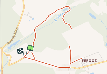
Tour Wandern von 21 km verfügbar auf Wallonien, Namur, Gembloux. Diese Tour wird von psyberty vorgeschlagen.
Beschreibung
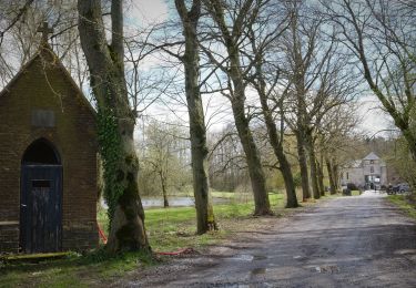
un morceau de trace est impossible à tracer mais pour le morceau manquant, prendre à droite labelle allée de tilleuls puis au croisement des 4 chemins, prendre à gauche et retrouver la trace.
Ort
Land:
Belgium
Region :
Wallonien
Abteilung/Provinz :
Namur
Kommune :
Gembloux
Standort:
Unknown
Gehen Sie:(Dec)
Gehen Sie:(UTM)
620209 ; 5599564 (31U) N.
Kommentare
Touren in der Umgebung
![Tour Wandern Jemeppe-sur-Sambre - De Balâtre à Tongrinne par la vallée de la Ligne - Photo](https://media.geolcdn.com/t/375/260/ext.jpg?maxdim=2&url=https%3A%2F%2Fservices.sitytrail.com%2FGeolivesWS%2FDownloadMedia.ashx%3FTrailID%3D95534%26Media%3De2db5dc2-0ab1-4cda-b9fd-3c87611cc9a3.jpg)
![Wandern Wandern](https://static1.geolcdn.com/sitytour/trail-icons/101.png)
De Balâtre à Tongrinne par la vallée de la Ligne
Wandern
Einfach
(1)
Jemeppe-sur-Sambre,
Wallonien,
Namur,
Belgium
![](/images/other/stat-length.png)
12,9 km | 15,4 km-effort
3h 0min
![](https://static1.geolcdn.com/siteimages/upload/files/16400158638029165_repeat_loop_refresh_sync_direction_icon.png)
Ja
![Tour Wandern Chastre - Balade récréative de Cortil - Photo](https://media.geolcdn.com/t/375/260/ext.jpg?maxdim=2&url=https%3A%2F%2Fservices.sitytrail.com%2FGeolivesWS%2FDownloadMedia.ashx%3FTrailID%3D232278%26Media%3D010369e0-b48e-4ca2-9215-837380cbac27.jpg)
![Wandern Wandern](https://static1.geolcdn.com/sitytour/trail-icons/101.png)
Balade récréative de Cortil
Wandern
Einfach
(4)
Chastre,
Wallonien,
Wallonisch-Brabant,
Belgium
![](/images/other/stat-length.png)
5,9 km | 6,5 km-effort
1h 26min
![](https://static1.geolcdn.com/siteimages/upload/files/16400158638029165_repeat_loop_refresh_sync_direction_icon.png)
Ja
![Tour Wandern Gembloux - Balade à Bossière - Gembloux - Photo](https://media.geolcdn.com/t/375/260/60cbd9cf-8e4d-4bbf-889b-adeed6ff6542.jpeg&format=jpg&maxdim=2)
![Wandern Wandern](https://static1.geolcdn.com/sitytour/trail-icons/101.png)
Balade à Bossière - Gembloux
Wandern
Medium
Gembloux,
Wallonien,
Namur,
Belgium
![](/images/other/stat-length.png)
9,4 km | 11,1 km-effort
2h 31min
![](https://static1.geolcdn.com/siteimages/upload/files/16400158638029165_repeat_loop_refresh_sync_direction_icon.png)
Ja
![Tour Wandern Gembloux - Balade de Gembloux à Corroy-le-Château - Photo](https://media.geolcdn.com/t/375/260/8bfe3e44-67e5-4d79-bff4-ef099b232ea5.jpg&format=jpg&maxdim=2)
![Wandern Wandern](https://static1.geolcdn.com/sitytour/trail-icons/101.png)
Balade de Gembloux à Corroy-le-Château
Wandern
Schwierig
Gembloux,
Wallonien,
Namur,
Belgium
![](/images/other/stat-length.png)
13,2 km | 15,3 km-effort
3h 28min
![](https://static1.geolcdn.com/siteimages/upload/files/16400158638029165_repeat_loop_refresh_sync_direction_icon.png)
Ja
![Tour Wandern Chastre - Saint Gery - Namur - par le GR126 - Photo](https://media.geolcdn.com/t/375/260/18f2aab5-a522-40c8-9ccf-e3f0f1d2197a.jpg&format=jpg&maxdim=2)
![Wandern Wandern](https://static1.geolcdn.com/sitytour/trail-icons/101.png)
Saint Gery - Namur - par le GR126
Wandern
Sehr schwierig
Chastre,
Wallonien,
Wallonisch-Brabant,
Belgium
![](/images/other/stat-length.png)
38 km | 45 km-effort
10h 7min
![](https://static1.geolcdn.com/siteimages/upload/files/16400158638029165_repeat_loop_refresh_sync_direction_icon.png)
Nein
![Tour Wandern Gembloux - SityTrail - Chastre - Perwez GR127 - Photo](https://media.geolcdn.com/t/375/260/70607764-bcef-4ec9-9b5f-6048d2579c09.jpg&format=jpg&maxdim=2)
![Wandern Wandern](https://static1.geolcdn.com/sitytour/trail-icons/101.png)
SityTrail - Chastre - Perwez GR127
Wandern
Sehr schwierig
Gembloux,
Wallonien,
Namur,
Belgium
![](/images/other/stat-length.png)
30 km | 33 km-effort
7h 28min
![](https://static1.geolcdn.com/siteimages/upload/files/16400158638029165_repeat_loop_refresh_sync_direction_icon.png)
Nein
![Wandern Wandern](https://static1.geolcdn.com/sitytour/trail-icons/101.png)
Bertinchamps, Ligny 1815, Ravel, Chaussée romaine
Wandern
Medium
Gembloux,
Wallonien,
Namur,
Belgium
![](/images/other/stat-length.png)
22 km | 24 km-effort
4h 51min
![](https://static1.geolcdn.com/siteimages/upload/files/16400158638029165_repeat_loop_refresh_sync_direction_icon.png)
Ja
![Tour Wandern Gembloux - covid 17-4-20 12 km - Photo](https://media.geolcdn.com/t/375/260/575ef2e1-64c3-47f4-a366-815bffa60540.jpg&format=jpg&maxdim=2)
![Wandern Wandern](https://static1.geolcdn.com/sitytour/trail-icons/101.png)
covid 17-4-20 12 km
Wandern
Sehr leicht
(1)
Gembloux,
Wallonien,
Namur,
Belgium
![](/images/other/stat-length.png)
12,8 km | 14,2 km-effort
2h 18min
![](https://static1.geolcdn.com/siteimages/upload/files/16400158638029165_repeat_loop_refresh_sync_direction_icon.png)
Ja
![Tour Wandern Jemeppe-sur-Sambre - BALADRE _ Salle Communale de Baladre_ Place communale _ 5190 -Baladre - Photo](https://media.geolcdn.com/t/375/260/ext.jpg?maxdim=2&url=https%3A%2F%2Fstatic1.geolcdn.com%2Fsiteimages%2Fupload%2Ffiles%2F1553511878bg_sport_marche.png)
![Wandern Wandern](https://static1.geolcdn.com/sitytour/trail-icons/101.png)
BALADRE _ Salle Communale de Baladre_ Place communale _ 5190 -Baladre
Wandern
Medium
(1)
Jemeppe-sur-Sambre,
Wallonien,
Namur,
Belgium
![](/images/other/stat-length.png)
13,1 km | 15,5 km-effort
3h 27min
![](https://static1.geolcdn.com/siteimages/upload/files/16400158638029165_repeat_loop_refresh_sync_direction_icon.png)
Ja