![](/images/other/stat-length.png)
Les coteaux d'Apremont
Levillefranchois
Benutzer
![Länge](/images/other/stat-length.png)
![Maximale Höhe](https://static1.geolcdn.com/siteimages/upload/files/1508320355ic_sort_altitude_max_24dp.png)
![Positive Höhendifferenz](https://static1.geolcdn.com/siteimages/upload/files/1508320355ic_sort_den_pos_24dp.png)
![Km-Effort](/images/other/stat-length.png)
![Min. Höhe](https://static1.geolcdn.com/siteimages/upload/files/1508320355ic_sort_altitude_min_24dp.png)
![Negative Höhendifferenz](https://static1.geolcdn.com/siteimages/upload/files/1508320355ic_sort_den_neg_24dp.png)
![Boucle](https://static1.geolcdn.com/siteimages/upload/files/16400158638029165_repeat_loop_refresh_sync_direction_icon.png)
![Mountainbike](https://static1.geolcdn.com/sitytour/trail-icons/202.png)
2h32
Schwierigkeit : Schwierig
![Scannen Sie diesen QR-Code, um die Tour in der SityTrail-Anwendung zu öffnen](https://capi.geolives.com/qq0zvz2zws4bq2lad0pu/sitytour/trails/3459010/qr.png?size=200)
Kostenlosegpshiking-Anwendung
Über SityTrail
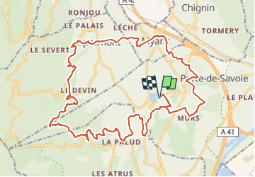
Tour Mountainbike von 27 km verfügbar auf Auvergne-Rhone-Alpen, Savoyen, Porte-de-Savoie. Diese Tour wird von Levillefranchois vorgeschlagen.
Beschreibung
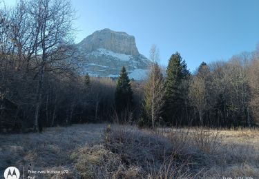
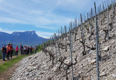
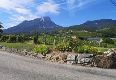
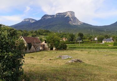
Boucle magnifique par ses paysages traversés et les vues sur la région des Marches (Combe de Savoie, Bauges, Belledonnes, Granier). En octobre-novembre, les couleurs des vignobles ajoutent un intéret supplementaire.
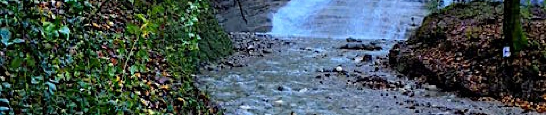
Du Lac St André, la premiere partie est trés facile, empruntant des routes et pistes larges. Puis la pente se redresse et est difficile par endroits. J'ai fait ce parcours apres la pluie et des zones sont franchement très ardues à franchir à cause de la glaise dans une sente étroite et raide. Donc temps sec plus que conseillé ! Le franchissement de la cascade du Pichut demande de franchir le ruisseau a pied et donc de retirer ses chaussures. pas de pont ni gué. L'eau ne touche pas le moteur si VTTAE. A partir du lac Noir (plus une gouille qu'un lac !!..) la descente dans la vallée se fait par des singles vraiment jolis. Puis le goudron permet de rejoindre le parking du départ.
Ort
Kommentare
Touren in der Umgebung
![Tour Wandern Chapareillan - Le Mont Granier 1933m, depuis Bellecombe - Photo](https://media.geolcdn.com/t/375/260/ext.jpg?maxdim=2&url=https%3A%2F%2Fservices.sitytrail.com%2FGeolivesWS%2FDownloadMedia.ashx%3FTrailID%3D106476%26Media%3D10999_1.jpg)
![Wandern Wandern](https://static1.geolcdn.com/sitytour/trail-icons/101.png)
Wandern
![](/images/other/stat-length.png)
![](https://static1.geolcdn.com/siteimages/upload/files/16400158638029165_repeat_loop_refresh_sync_direction_icon.png)
![Tour Wandern Chapareillan - Le Granier 1933m, par les pas de la Porte et de Bellecombe - Photo](https://media.geolcdn.com/t/375/260/ext.jpg?maxdim=2&url=https%3A%2F%2Fservices.sitytrail.com%2FGeolivesWS%2FDownloadMedia.ashx%3FTrailID%3D102833%26Media%3D3997_1.jpg)
![Wandern Wandern](https://static1.geolcdn.com/sitytour/trail-icons/101.png)
Wandern
![](/images/other/stat-length.png)
![](https://static1.geolcdn.com/siteimages/upload/files/16400158638029165_repeat_loop_refresh_sync_direction_icon.png)
![Tour Wandern Porte-de-Savoie - lac noir - Photo](https://media.geolcdn.com/t/375/260/499f9890-28e0-48a3-ad89-8f41232ea1db.jpg&format=jpg&maxdim=2)
![Wandern Wandern](https://static1.geolcdn.com/sitytour/trail-icons/101.png)
Wandern
![](/images/other/stat-length.png)
![](https://static1.geolcdn.com/siteimages/upload/files/16400158638029165_repeat_loop_refresh_sync_direction_icon.png)
![Tour Nordic Walking Chignin - Chignin - Arbin à travers les vignes et coteaux - Photo](https://media.geolcdn.com/t/375/260/57c2a674-7c91-4476-9328-bd442983023e.jpg&format=jpg&maxdim=2)
![Nordic Walking Nordic Walking](https://static1.geolcdn.com/sitytour/trail-icons/102.png)
Nordic Walking
![](/images/other/stat-length.png)
![](https://static1.geolcdn.com/siteimages/upload/files/16400158638029165_repeat_loop_refresh_sync_direction_icon.png)
![Tour Wandern Apremont - 20190830 - Golf et Lac des Pères - Photo](https://media.geolcdn.com/t/375/260/34747fae-a240-48da-af1e-c5fd73f2ee52.jpg&format=jpg&maxdim=2)
![Wandern Wandern](https://static1.geolcdn.com/sitytour/trail-icons/101.png)
Wandern
![](/images/other/stat-length.png)
![](https://static1.geolcdn.com/siteimages/upload/files/16400158638029165_repeat_loop_refresh_sync_direction_icon.png)
![Tour Wandern Apremont - 20190816 - Bélisay (Myans) - Photo](https://media.geolcdn.com/t/375/260/afaf4216-858a-4b40-95ec-5ccdfc1a4901.jpg&format=jpg&maxdim=2)
![Wandern Wandern](https://static1.geolcdn.com/sitytour/trail-icons/101.png)
Wandern
![](/images/other/stat-length.png)
![](https://static1.geolcdn.com/siteimages/upload/files/16400158638029165_repeat_loop_refresh_sync_direction_icon.png)
![Tour Wandern Apremont - 20190814 - Lac Saint André - Photo](https://media.geolcdn.com/t/375/260/83860ba6-a9df-487a-a16d-c6a30d872cc1.jpg&format=jpg&maxdim=2)
![Wandern Wandern](https://static1.geolcdn.com/sitytour/trail-icons/101.png)
Wandern
![](/images/other/stat-length.png)
![](https://static1.geolcdn.com/siteimages/upload/files/16400158638029165_repeat_loop_refresh_sync_direction_icon.png)
![Tour Wandern Apremont - 180823-Pierre Hâchée - Photo](https://media.geolcdn.com/t/375/260/1bd122ea-55eb-4885-b5a8-f907a50842fc.jpg&format=jpg&maxdim=2)
![Wandern Wandern](https://static1.geolcdn.com/sitytour/trail-icons/101.png)
Wandern
![](/images/other/stat-length.png)
![](https://static1.geolcdn.com/siteimages/upload/files/16400158638029165_repeat_loop_refresh_sync_direction_icon.png)
![Tour Wandern Apremont - Chemin de l'Abis - Photo](https://media.geolcdn.com/t/375/260/ext.jpg?maxdim=2&url=https%3A%2F%2Fservices.sitytrail.com%2FGeolivesWS%2FDownloadMedia.ashx%3FTrailID%3D978597%26Media%3Dfix__20180602101929.jpg)
![Wandern Wandern](https://static1.geolcdn.com/sitytour/trail-icons/101.png)
Wandern
![](/images/other/stat-length.png)
![](https://static1.geolcdn.com/siteimages/upload/files/16400158638029165_repeat_loop_refresh_sync_direction_icon.png)