![](/images/other/stat-length.png)
![Tour Wandern Landgraaf - 2022-11-11_18h09m21_wandelroute---landgraaf---de-weg-de-worm-en-de-watertoren-in-parkstad - Photo](https://media.geolcdn.com/t/1900/400/ext.pjpeg?maxdim=2&url=https%3A%2F%2Fstatic1.geolcdn.com%2Fsiteimages%2Fupload%2Ffiles%2F1553511878bg_sport_marche.png)
2022-11-11_18h09m21_wandelroute---landgraaf---de-weg-de-worm-en-de-watertoren-in-parkstad
mumu.larandonneuse
Benutzer GUIDE
![Länge](/images/other/stat-length.png)
![Maximale Höhe](https://static1.geolcdn.com/siteimages/upload/files/1508320355ic_sort_altitude_max_24dp.png)
![Positive Höhendifferenz](https://static1.geolcdn.com/siteimages/upload/files/1508320355ic_sort_den_pos_24dp.png)
![Km-Effort](/images/other/stat-length.png)
![Min. Höhe](https://static1.geolcdn.com/siteimages/upload/files/1508320355ic_sort_altitude_min_24dp.png)
![Negative Höhendifferenz](https://static1.geolcdn.com/siteimages/upload/files/1508320355ic_sort_den_neg_24dp.png)
![Boucle](https://static1.geolcdn.com/siteimages/upload/files/16400158638029165_repeat_loop_refresh_sync_direction_icon.png)
![Wandern](https://static1.geolcdn.com/sitytour/trail-icons/101.png)
3h20
Schwierigkeit : Medium
![Scannen Sie diesen QR-Code, um die Tour in der SityTrail-Anwendung zu öffnen](https://capi.geolives.com/qq0zvz2zws4bq2lad0pu/sitytour/trails/3453725/qr.png?size=200)
Kostenlosegpshiking-Anwendung
Über SityTrail
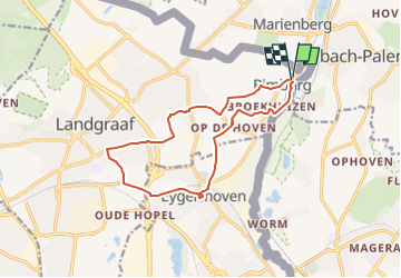
Tour Wandern von 12,3 km verfügbar auf Limburg, Unbekannt, Landgraaf. Diese Tour wird von mumu.larandonneuse vorgeschlagen.
Beschreibung
ℹ www.visitzuidlimburg.nl
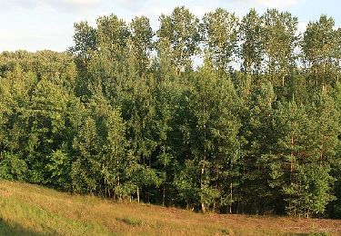
➡️ Cette promenade à travers la région minière orientale passe par Rimburg, Eygelshoven et Landgraaf. En chemin, vous découvrirez les traces laissées ici par les Romains : certaines très tangibles, comme une borne milliaire le long de la route, et d'autres plus abstraites comme le paysage.
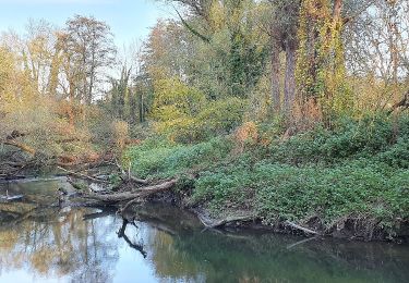
Il y a environ deux mille ans, les Romains ont construit la Via Belgica : une route de Cologne et d'Allemagne à Boulogne-sur-Mer en France. À Rimburg, la Via Belgica traversait la rivière Worm et pénétrait ici aux Pays-Bas.
La façon dont elle a continué son chemin n'est pas encore certaine, mais Eygelshoven et Landgraaf contiennent également de nombreuses traces romaines.
📍 Brugstraat 16 Landgraaf.
Ort
Kommentare
Touren in der Umgebung
![Tour Zu Fuß Landgraaf - Gravenrode route 2 (groen) - Photo](https://media.geolcdn.com/t/375/260/f73a123d-5fd5-49b5-a94a-94d3b8c69efc.jpeg&format=jpg&maxdim=2)
![Zu Fuß Zu Fuß](https://static1.geolcdn.com/sitytour/trail-icons/100.png)
Zu Fuß
![](/images/other/stat-length.png)
![](https://static1.geolcdn.com/siteimages/upload/files/16400158638029165_repeat_loop_refresh_sync_direction_icon.png)
![Tour Zu Fuß Kerkrade - Gravenrode route 5 (rood) - Photo](https://media.geolcdn.com/t/375/260/13e30182-53e9-449d-9825-8bfcda7e989f.jpeg&format=jpg&maxdim=2)
![Zu Fuß Zu Fuß](https://static1.geolcdn.com/sitytour/trail-icons/100.png)
Zu Fuß
![](/images/other/stat-length.png)
![](https://static1.geolcdn.com/siteimages/upload/files/16400158638029165_repeat_loop_refresh_sync_direction_icon.png)
![Tour Zu Fuß Kerkrade - Gravenrode route 6 (blauw) - Photo](https://media.geolcdn.com/t/375/260/13e30182-53e9-449d-9825-8bfcda7e989f.jpeg&format=jpg&maxdim=2)
![Zu Fuß Zu Fuß](https://static1.geolcdn.com/sitytour/trail-icons/100.png)
Zu Fuß
![](/images/other/stat-length.png)
![](https://static1.geolcdn.com/siteimages/upload/files/16400158638029165_repeat_loop_refresh_sync_direction_icon.png)
![Tour Zu Fuß Herzogenrath - Wasserweg Wurm - Photo](https://media.geolcdn.com/t/375/260/5acb8839-d86c-4bb2-9515-e9221306d6a1.jpeg&format=jpg&maxdim=2)
![Zu Fuß Zu Fuß](https://static1.geolcdn.com/sitytour/trail-icons/100.png)
Zu Fuß
![](/images/other/stat-length.png)
![](https://static1.geolcdn.com/siteimages/upload/files/16400158638029165_repeat_loop_refresh_sync_direction_icon.png)
![Tour Zu Fuß Gangelt - DE-Großer Rundweg - Photo](https://media.geolcdn.com/t/375/260/71eefdf8-006b-4c1c-9a8a-a84d3bd15b54.jpeg&format=jpg&maxdim=2)
![Zu Fuß Zu Fuß](https://static1.geolcdn.com/sitytour/trail-icons/100.png)
Zu Fuß
![](/images/other/stat-length.png)
![](https://static1.geolcdn.com/siteimages/upload/files/16400158638029165_repeat_loop_refresh_sync_direction_icon.png)
![Tour Zu Fuß Gangelt - Seerundweg - Photo](https://media.geolcdn.com/t/375/260/71eefdf8-006b-4c1c-9a8a-a84d3bd15b54.jpeg&format=jpg&maxdim=2)
![Zu Fuß Zu Fuß](https://static1.geolcdn.com/sitytour/trail-icons/100.png)
Zu Fuß
![](/images/other/stat-length.png)
![](https://static1.geolcdn.com/siteimages/upload/files/16400158638029165_repeat_loop_refresh_sync_direction_icon.png)
![Tour Zu Fuß Geilenkirchen - Moorrundweg - Photo](https://media.geolcdn.com/t/375/260/71eefdf8-006b-4c1c-9a8a-a84d3bd15b54.jpeg&format=jpg&maxdim=2)
![Zu Fuß Zu Fuß](https://static1.geolcdn.com/sitytour/trail-icons/100.png)
Zu Fuß
![](/images/other/stat-length.png)
![](https://static1.geolcdn.com/siteimages/upload/files/16400158638029165_repeat_loop_refresh_sync_direction_icon.png)
![Tour Zu Fuß Herzogenrath - NaturFreundeWeg Rund um Merkstein - Photo](https://media.geolcdn.com/t/375/260/f946095f-3242-4aff-b0a5-5d98a4f6e9ea.jpeg&format=jpg&maxdim=2)
![Zu Fuß Zu Fuß](https://static1.geolcdn.com/sitytour/trail-icons/100.png)
Zu Fuß
![](/images/other/stat-length.png)
![](https://static1.geolcdn.com/siteimages/upload/files/16400158638029165_repeat_loop_refresh_sync_direction_icon.png)
![Tour Zu Fuß Übach-Palenberg - Heiderundweg - Photo](https://media.geolcdn.com/t/375/260/71eefdf8-006b-4c1c-9a8a-a84d3bd15b54.jpeg&format=jpg&maxdim=2)
![Zu Fuß Zu Fuß](https://static1.geolcdn.com/sitytour/trail-icons/100.png)
Zu Fuß
![](/images/other/stat-length.png)
![](https://static1.geolcdn.com/siteimages/upload/files/16400158638029165_repeat_loop_refresh_sync_direction_icon.png)