![](/images/other/stat-length.png)
![Tour Wandern Sanary-sur-Mer - trail La Gorguette au Petit Cerveau - Photo](https://media.geolcdn.com/t/1900/400/906c8fad-6be4-40bb-8623-83dad3a16367.jpg&format=pjpeg&maxdim=2)
trail La Gorguette au Petit Cerveau
Robertplessier
Benutzer
![Länge](/images/other/stat-length.png)
![Maximale Höhe](https://static1.geolcdn.com/siteimages/upload/files/1508320355ic_sort_altitude_max_24dp.png)
![Positive Höhendifferenz](https://static1.geolcdn.com/siteimages/upload/files/1508320355ic_sort_den_pos_24dp.png)
![Km-Effort](/images/other/stat-length.png)
![Min. Höhe](https://static1.geolcdn.com/siteimages/upload/files/1508320355ic_sort_altitude_min_24dp.png)
![Negative Höhendifferenz](https://static1.geolcdn.com/siteimages/upload/files/1508320355ic_sort_den_neg_24dp.png)
![Boucle](https://static1.geolcdn.com/siteimages/upload/files/16400158638029165_repeat_loop_refresh_sync_direction_icon.png)
![Wandern](https://static1.geolcdn.com/sitytour/trail-icons/101.png)
5h04
Schwierigkeit : Schwierig
![Pfad](https://static1.geolcdn.com/sitytour/trail-icons/104.png)
2h10
Schwierigkeit : Medium
![Scannen Sie diesen QR-Code, um die Tour in der SityTrail-Anwendung zu öffnen](https://capi.geolives.com/qq0zvz2zws4bq2lad0pu/sitytour/trails/3449293/qr.png?size=200)
Kostenlosegpshiking-Anwendung
Über SityTrail
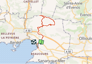
Tour Wandern von 14,9 km verfügbar auf Provence-Alpes-Côte d'Azur, Var, Sanary-sur-Mer. Diese Tour wird von Robertplessier vorgeschlagen.
Beschreibung
Trail (ou le faire en marchant), à partir quasiment de la plage de la Gorguette, montée au travers des maisons, passage au niveau des vignes, puis chemin jusqu'au sommet, plusieurs redescentes possibles par chemins, puis reprendre route de l'aller pour finir.
Ort
Kommentare
Touren in der Umgebung
![Tour Wandern Bandol - SityTrail - fregate - Photo](https://media.geolcdn.com/t/375/260/2853a075-1e77-4b06-bf33-9c03418a8afd.jpg&format=jpg&maxdim=2)
![Wandern Wandern](https://static1.geolcdn.com/sitytour/trail-icons/101.png)
Wandern
![](/images/other/stat-length.png)
![](https://static1.geolcdn.com/siteimages/upload/files/16400158638029165_repeat_loop_refresh_sync_direction_icon.png)
![Tour Wandern Évenos - SityTrail - st anne d'evenos. - Photo](https://media.geolcdn.com/t/375/260/1a61a6ef-600e-4900-ae4e-54737b695f44.jpg&format=jpg&maxdim=2)
![Wandern Wandern](https://static1.geolcdn.com/sitytour/trail-icons/101.png)
Wandern
![](/images/other/stat-length.png)
![](https://static1.geolcdn.com/siteimages/upload/files/16400158638029165_repeat_loop_refresh_sync_direction_icon.png)
![Tour Wandern Six-Fours les Plages - ND de Pepiole via colline du fort de Six-Fours, retour par Les Lônes - Photo](https://media.geolcdn.com/t/375/260/1379151f-75a9-4587-8d69-64d0542e06ca.jpg&format=jpg&maxdim=2)
![Wandern Wandern](https://static1.geolcdn.com/sitytour/trail-icons/101.png)
Wandern
![](/images/other/stat-length.png)
![](https://static1.geolcdn.com/siteimages/upload/files/16400158638029165_repeat_loop_refresh_sync_direction_icon.png)
![Tour Wandern Bandol - SityTrail - Tour du golf de la Fregate (version longue ) - Photo](https://media.geolcdn.com/t/375/260/53cbdef8-8c49-42e8-bcb8-017960282ccb.jpg&format=jpg&maxdim=2)
![Wandern Wandern](https://static1.geolcdn.com/sitytour/trail-icons/101.png)
Wandern
![](/images/other/stat-length.png)
![](https://static1.geolcdn.com/siteimages/upload/files/16400158638029165_repeat_loop_refresh_sync_direction_icon.png)
![Tour Wandern Six-Fours les Plages - ND de Pepiole via colline du fort de Six-Fours - Photo](https://media.geolcdn.com/t/375/260/1379151f-75a9-4587-8d69-64d0542e06ca.jpg&format=jpg&maxdim=2)
![Wandern Wandern](https://static1.geolcdn.com/sitytour/trail-icons/101.png)
Wandern
![](/images/other/stat-length.png)
![](https://static1.geolcdn.com/siteimages/upload/files/16400158638029165_repeat_loop_refresh_sync_direction_icon.png)
![Tour Wandern Évenos - Sainte Anne d'Evenos Le Gros Cerveau - Photo](https://media.geolcdn.com/t/375/260/ext.jpg?maxdim=2&url=https%3A%2F%2Fservices.sitytrail.com%2FGeolivesWS%2FDownloadMedia.ashx%3FTrailID%3D104105%26Media%3D7169_2.jpg)
![Wandern Wandern](https://static1.geolcdn.com/sitytour/trail-icons/101.png)
Wandern
![](/images/other/stat-length.png)
![](https://static1.geolcdn.com/siteimages/upload/files/16400158638029165_repeat_loop_refresh_sync_direction_icon.png)
![Tour Wandern Bandol - Rando Bandol - Port d'Alon - Bandol - Photo](https://media.geolcdn.com/t/375/260/ext.jpg?maxdim=2&url=https%3A%2F%2Fservices.sitytrail.com%2FGeolivesWS%2FDownloadMedia.ashx%3FTrailID%3D103781%26Media%3D6551_1.jpg)
![Wandern Wandern](https://static1.geolcdn.com/sitytour/trail-icons/101.png)
Wandern
![](/images/other/stat-length.png)
![](https://static1.geolcdn.com/siteimages/upload/files/16400158638029165_repeat_loop_refresh_sync_direction_icon.png)
![Tour Wandern Évenos - 83 grès ste anne - Photo](https://media.geolcdn.com/t/375/260/4065f763-de74-4ec5-8986-258e029c817d.jpg&format=jpg&maxdim=2)
![Wandern Wandern](https://static1.geolcdn.com/sitytour/trail-icons/101.png)
Wandern
![](/images/other/stat-length.png)
![](https://static1.geolcdn.com/siteimages/upload/files/16400158638029165_repeat_loop_refresh_sync_direction_icon.png)
![Tour Wandern Bandol - SityTrail - Boucle Bandol - Port d'Alon - Dune de sable - La Madrague - Port d'Alon - Bandol - Photo](https://media.geolcdn.com/t/375/260/ext.jpg?maxdim=2&url=https%3A%2F%2Fstatic1.geolcdn.com%2Fsiteimages%2Fupload%2Ffiles%2F1553511878bg_sport_marche.png)
![Wandern Wandern](https://static1.geolcdn.com/sitytour/trail-icons/101.png)
Wandern
![](/images/other/stat-length.png)
![](https://static1.geolcdn.com/siteimages/upload/files/16400158638029165_repeat_loop_refresh_sync_direction_icon.png)