![](/images/other/stat-length.png)
![Tour Wandern Wavre - Autour de Stadt - Photo](https://media.geolcdn.com/t/1900/400/ext.pjpeg?maxdim=2&url=https%3A%2F%2Fstatic1.geolcdn.com%2Fsiteimages%2Fupload%2Ffiles%2F1553511878bg_sport_marche.png)
Autour de Stadt
Jean Goossens
Benutzer
![Länge](/images/other/stat-length.png)
Länge
6 km
![Maximale Höhe](https://static1.geolcdn.com/siteimages/upload/files/1508320355ic_sort_altitude_max_24dp.png)
Maximale Höhe
114 m
![Positive Höhendifferenz](https://static1.geolcdn.com/siteimages/upload/files/1508320355ic_sort_den_pos_24dp.png)
Positive Höhendifferenz
119 m
![Km-Effort](/images/other/stat-length.png)
Km-Effort
7,6 km
![Min. Höhe](https://static1.geolcdn.com/siteimages/upload/files/1508320355ic_sort_altitude_min_24dp.png)
Min. Höhe
47 m
![Negative Höhendifferenz](https://static1.geolcdn.com/siteimages/upload/files/1508320355ic_sort_den_neg_24dp.png)
Negative Höhendifferenz
123 m
![Boucle](https://static1.geolcdn.com/siteimages/upload/files/16400158638029165_repeat_loop_refresh_sync_direction_icon.png)
Boucle
Ja
Erstellungsdatum :
2022-11-04 09:46:29.655
Letzte Änderung :
2022-11-04 10:03:00.19
![Wandern](https://static1.geolcdn.com/sitytour/trail-icons/101.png)
1h44
Schwierigkeit : Medium
![Scannen Sie diesen QR-Code, um die Tour in der SityTrail-Anwendung zu öffnen](https://capi.geolives.com/qq0zvz2zws4bq2lad0pu/sitytour/trails/3445939/qr.png?size=200)
Kostenlosegpshiking-Anwendung
Über SityTrail
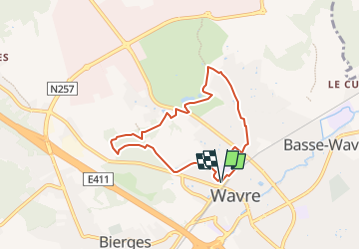
Tour Wandern von 6 km verfügbar auf Wallonien, Wallonisch-Brabant, Wavre. Diese Tour wird von Jean Goossens vorgeschlagen.
Beschreibung
départ du parking des mésanges, traversée du Bois Ste Anne et montée à Stadt en longeant le golf de la Bawette. retour à Wavre en traversant le nouveau lotissement de Val Vena.
Ort
Land:
Belgium
Region :
Wallonien
Abteilung/Provinz :
Wallonisch-Brabant
Kommune :
Wavre
Standort:
Wavre
Gehen Sie:(Dec)
Gehen Sie:(UTM)
613372 ; 5619667 (31U) N.
Kommentare
Touren in der Umgebung
![Tour Wandern Grez-Doiceau - GG-Bw-01_Archennes - Wavre - Photo](https://media.geolcdn.com/t/375/260/290bb459-f7c0-458a-900e-424f97fa157f.jpg&format=jpg&maxdim=2)
![Wandern Wandern](https://static1.geolcdn.com/sitytour/trail-icons/101.png)
GG-Bw-01_Archennes - Wavre
Wandern
Sehr schwierig
(7)
Grez-Doiceau,
Wallonien,
Wallonisch-Brabant,
Belgium
![](/images/other/stat-length.png)
23 km | 28 km-effort
5h 59min
![](https://static1.geolcdn.com/siteimages/upload/files/16400158638029165_repeat_loop_refresh_sync_direction_icon.png)
Nein
![Tour Wandern Chaumont-Gistoux - De Dion-le Mont à Dion-le Val par la vallée du Pisselet - Photo](https://media.geolcdn.com/t/375/260/ext.jpg?maxdim=2&url=https%3A%2F%2Fstatic1.geolcdn.com%2Fsiteimages%2Fupload%2Ffiles%2F1553511878bg_sport_marche.png)
![Wandern Wandern](https://static1.geolcdn.com/sitytour/trail-icons/101.png)
De Dion-le Mont à Dion-le Val par la vallée du Pisselet
Wandern
Sehr leicht
(8)
Chaumont-Gistoux,
Wallonien,
Wallonisch-Brabant,
Belgium
![](/images/other/stat-length.png)
8,6 km | 10,3 km-effort
2h 0min
![](https://static1.geolcdn.com/siteimages/upload/files/16400158638029165_repeat_loop_refresh_sync_direction_icon.png)
Ja
![Wandern Wandern](https://static1.geolcdn.com/sitytour/trail-icons/101.png)
SityTrail - #181130 - Autour de Vieusart, version courte
Wandern
Medium
(1)
Chaumont-Gistoux,
Wallonien,
Wallonisch-Brabant,
Belgium
![](/images/other/stat-length.png)
7,7 km | 9,3 km-effort
2h 6min
![](https://static1.geolcdn.com/siteimages/upload/files/16400158638029165_repeat_loop_refresh_sync_direction_icon.png)
Ja
![Tour Wandern Chaumont-Gistoux - BE-Chaumont-Gistoux - Vieusart - Photo](https://media.geolcdn.com/t/375/260/8d29a104-ec49-41f1-a812-8df11e0d7db1.jpg&format=jpg&maxdim=2)
![Wandern Wandern](https://static1.geolcdn.com/sitytour/trail-icons/101.png)
BE-Chaumont-Gistoux - Vieusart
Wandern
(1)
Chaumont-Gistoux,
Wallonien,
Wallonisch-Brabant,
Belgium
![](/images/other/stat-length.png)
5,6 km | 6,6 km-effort
1h 18min
![](https://static1.geolcdn.com/siteimages/upload/files/16400158638029165_repeat_loop_refresh_sync_direction_icon.png)
Ja
![Tour Wandern Rixensart - Balade de Rixensart au lac de Genval - Photo](https://media.geolcdn.com/t/375/260/ext.jpg?maxdim=2&url=https%3A%2F%2Fservices.sitytrail.com%2FGeolivesWS%2FDownloadMedia.ashx%3FTrailID%3D486338%26Media%3D5e34c7a6-42f3-4c4e-bd52-3a98cd84457e.JPG)
![Wandern Wandern](https://static1.geolcdn.com/sitytour/trail-icons/101.png)
Balade de Rixensart au lac de Genval
Wandern
Einfach
(2)
Rixensart,
Wallonien,
Wallonisch-Brabant,
Belgium
![](/images/other/stat-length.png)
10,8 km | 13,3 km-effort
2h 52min
![](https://static1.geolcdn.com/siteimages/upload/files/16400158638029165_repeat_loop_refresh_sync_direction_icon.png)
Ja
![Wandern Wandern](https://static1.geolcdn.com/sitytour/trail-icons/101.png)
Lauzelle - Circuit Natura 2000, des sites qui valent le détour ! - Bw01
Wandern
Einfach
(2)
Ottignies-Louvain-la-Neuve,
Wallonien,
Wallonisch-Brabant,
Belgium
![](/images/other/stat-length.png)
3,8 km | 4,8 km-effort
1h 26min
![](https://static1.geolcdn.com/siteimages/upload/files/16400158638029165_repeat_loop_refresh_sync_direction_icon.png)
Ja
![Tour Wandern Wavre - RB-BW-07 - Des montagnes russes près de Wavre - Photo](https://media.geolcdn.com/t/375/260/ext.jpg?maxdim=2&url=https%3A%2F%2Fservices.sitytrail.com%2FGeolivesWS%2FDownloadMedia.ashx%3FTrailID%3D179582%26Media%3D72f18e5f-b96b-4732-9bbe-457fabd000c2.jpg)
![Wandern Wandern](https://static1.geolcdn.com/sitytour/trail-icons/101.png)
RB-BW-07 - Des montagnes russes près de Wavre
Wandern
Medium
(4)
Wavre,
Wallonien,
Wallonisch-Brabant,
Belgium
![](/images/other/stat-length.png)
27 km | 34 km-effort
7h 5min
![](https://static1.geolcdn.com/siteimages/upload/files/16400158638029165_repeat_loop_refresh_sync_direction_icon.png)
Ja
![Wandern Wandern](https://static1.geolcdn.com/sitytour/trail-icons/101.png)
#221104 - Florival > Pécrot, GRP127
Wandern
Medium
(2)
Grez-Doiceau,
Wallonien,
Wallonisch-Brabant,
Belgium
![](/images/other/stat-length.png)
7 km | 8,4 km-effort
1h 55min
![](https://static1.geolcdn.com/siteimages/upload/files/16400158638029165_repeat_loop_refresh_sync_direction_icon.png)
Ja
![Wandern Wandern](https://static1.geolcdn.com/sitytour/trail-icons/101.png)
#210507 Dion-le-Mont, Pisselet et Louvranges
Wandern
Medium
(1)
Chaumont-Gistoux,
Wallonien,
Wallonisch-Brabant,
Belgium
![](/images/other/stat-length.png)
6,5 km | 7,9 km-effort
2h 12min
![](https://static1.geolcdn.com/siteimages/upload/files/16400158638029165_repeat_loop_refresh_sync_direction_icon.png)
Ja