![](/images/other/stat-length.png)
![Tour Rennrad Le Gua - Boucle par col de l'Arzelier sens horaire. - Photo](https://media.geolcdn.com/t/1900/400/ext.pjpeg?maxdim=2&url=https%3A%2F%2Fstatic1.geolcdn.com%2Fsiteimages%2Fupload%2Ffiles%2F1524743154velo.jpg)
Boucle par col de l'Arzelier sens horaire.
Lanry38
Benutzer
![Länge](/images/other/stat-length.png)
Länge
46 km
![Maximale Höhe](https://static1.geolcdn.com/siteimages/upload/files/1508320355ic_sort_altitude_max_24dp.png)
Maximale Höhe
1234 m
![Positive Höhendifferenz](https://static1.geolcdn.com/siteimages/upload/files/1508320355ic_sort_den_pos_24dp.png)
Positive Höhendifferenz
1318 m
![Km-Effort](/images/other/stat-length.png)
Km-Effort
64 km
![Min. Höhe](https://static1.geolcdn.com/siteimages/upload/files/1508320355ic_sort_altitude_min_24dp.png)
Min. Höhe
524 m
![Negative Höhendifferenz](https://static1.geolcdn.com/siteimages/upload/files/1508320355ic_sort_den_neg_24dp.png)
Negative Höhendifferenz
1320 m
![Boucle](https://static1.geolcdn.com/siteimages/upload/files/16400158638029165_repeat_loop_refresh_sync_direction_icon.png)
Boucle
Ja
Erstellungsdatum :
2022-10-25 16:16:34.1
Letzte Änderung :
2022-10-25 16:32:19.131
![Rennrad](https://static1.geolcdn.com/sitytour/trail-icons/201.png)
3h52
Schwierigkeit : Sehr schwierig
![Scannen Sie diesen QR-Code, um die Tour in der SityTrail-Anwendung zu öffnen](https://capi.geolives.com/qq0zvz2zws4bq2lad0pu/sitytour/trails/3435385/qr.png?size=200)
Kostenlosegpshiking-Anwendung
Über SityTrail
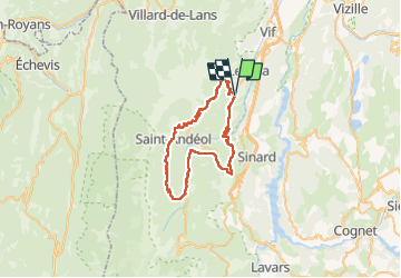
Tour Rennrad von 46 km verfügbar auf Auvergne-Rhone-Alpen, Isère, Le Gua. Diese Tour wird von Lanry38 vorgeschlagen.
Beschreibung
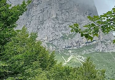
Tracé évitant l'éboulement entre Lânchâtre et St Guillaume, la route sera coupée jusqu'en septembre 2023.
Le détour va de Lanchâtre à St Guillaume en passant par St Paul lès Monestiers. Attention pour les cyclos route, il y a 2 km de piste peu après Lanchâtre.
Ort
Land:
France
Region :
Auvergne-Rhone-Alpen
Abteilung/Provinz :
Isère
Kommune :
Le Gua
Standort:
Unknown
Gehen Sie:(Dec)
Gehen Sie:(UTM)
707234 ; 4986293 (31T) N.
Kommentare
Touren in der Umgebung
![Tour Wandern Villard-de-Lans - villard col des 2 soeurs - Photo](https://media.geolcdn.com/t/375/260/ext.jpg?maxdim=2&url=https%3A%2F%2Fservices.sitytrail.com%2FGeolivesWS%2FDownloadMedia.ashx%3FTrailID%3D453991%26Media%3Dfix__20150803124330.jpg)
![Wandern Wandern](https://static1.geolcdn.com/sitytour/trail-icons/101.png)
villard col des 2 soeurs
Wandern
Medium
(1)
Villard-de-Lans,
Auvergne-Rhone-Alpen,
Isère,
France
![](/images/other/stat-length.png)
7,7 km | 13,8 km-effort
2h 45min
![](https://static1.geolcdn.com/siteimages/upload/files/16400158638029165_repeat_loop_refresh_sync_direction_icon.png)
Ja
![Tour Wandern Château-Bernard - la soldanelle - Photo](https://media.geolcdn.com/t/375/260/75f3f6c9-7fa9-4e53-8263-c310156b3409.jpg&format=jpg&maxdim=2)
![Wandern Wandern](https://static1.geolcdn.com/sitytour/trail-icons/101.png)
la soldanelle
Wandern
Einfach
(1)
Château-Bernard,
Auvergne-Rhone-Alpen,
Isère,
France
![](/images/other/stat-length.png)
6,1 km | 10,8 km-effort
3h 17min
![](https://static1.geolcdn.com/siteimages/upload/files/16400158638029165_repeat_loop_refresh_sync_direction_icon.png)
Nein
![Tour Wandern Villard-de-Lans - lac de Moucherolle par les liapaz - Photo](https://media.geolcdn.com/t/375/260/f566df8e-f7a1-49c6-82b0-31013bff1844.jpg&format=jpg&maxdim=2)
![Wandern Wandern](https://static1.geolcdn.com/sitytour/trail-icons/101.png)
lac de Moucherolle par les liapaz
Wandern
Schwierig
Villard-de-Lans,
Auvergne-Rhone-Alpen,
Isère,
France
![](/images/other/stat-length.png)
7,2 km | 12,9 km-effort
3h 11min
![](https://static1.geolcdn.com/siteimages/upload/files/16400158638029165_repeat_loop_refresh_sync_direction_icon.png)
Ja
![Tour Wandern Villard-de-Lans - 38 pas oeille balcon est col vert - Photo](https://media.geolcdn.com/t/375/260/7892b9e6-96d1-42a4-ab0a-49847b077e32.jpg&format=jpg&maxdim=2)
![Wandern Wandern](https://static1.geolcdn.com/sitytour/trail-icons/101.png)
38 pas oeille balcon est col vert
Wandern
Medium
Villard-de-Lans,
Auvergne-Rhone-Alpen,
Isère,
France
![](/images/other/stat-length.png)
15 km | 25 km-effort
7h 4min
![](https://static1.geolcdn.com/siteimages/upload/files/16400158638029165_repeat_loop_refresh_sync_direction_icon.png)
Nein
![Tour Wandern Villard-de-Lans - La petite sœur Sophie - Photo](https://media.geolcdn.com/t/375/260/15393ab1-dd3f-4e01-a88d-7ba7dfca0d21.jpg&format=jpg&maxdim=2)
![Wandern Wandern](https://static1.geolcdn.com/sitytour/trail-icons/101.png)
La petite sœur Sophie
Wandern
Schwierig
Villard-de-Lans,
Auvergne-Rhone-Alpen,
Isère,
France
![](/images/other/stat-length.png)
8 km | 15,7 km-effort
4h 23min
![](https://static1.geolcdn.com/siteimages/upload/files/16400158638029165_repeat_loop_refresh_sync_direction_icon.png)
Ja
![Tour Wandern Villard-de-Lans - la grande moucherolle Agathe et Sophie - Photo](https://media.geolcdn.com/t/375/260/57330813-7d1a-480f-9d58-934cead0ae0b.jpg&format=jpg&maxdim=2)
![Wandern Wandern](https://static1.geolcdn.com/sitytour/trail-icons/101.png)
la grande moucherolle Agathe et Sophie
Wandern
Schwierig
Villard-de-Lans,
Auvergne-Rhone-Alpen,
Isère,
France
![](/images/other/stat-length.png)
11,8 km | 25 km-effort
7h 8min
![](https://static1.geolcdn.com/siteimages/upload/files/16400158638029165_repeat_loop_refresh_sync_direction_icon.png)
Nein
![Tour Wandern Château-Bernard - tête des chaudières et rocher de la Balme - Photo](https://media.geolcdn.com/t/375/260/0195d12b-3165-4d3f-81a6-2df422d450fa.jpg&format=jpg&maxdim=2)
![Wandern Wandern](https://static1.geolcdn.com/sitytour/trail-icons/101.png)
tête des chaudières et rocher de la Balme
Wandern
Medium
Château-Bernard,
Auvergne-Rhone-Alpen,
Isère,
France
![](/images/other/stat-length.png)
19,2 km | 36 km-effort
7h 22min
![](https://static1.geolcdn.com/siteimages/upload/files/16400158638029165_repeat_loop_refresh_sync_direction_icon.png)
Ja
![Tour Wandern Château-Bernard - sous pas Balme de Arzelier - Photo](https://media.geolcdn.com/t/375/260/ad496dd6-d014-4fff-96cc-8f3a271c17a6.jpg&format=jpg&maxdim=2)
![Wandern Wandern](https://static1.geolcdn.com/sitytour/trail-icons/101.png)
sous pas Balme de Arzelier
Wandern
Medium
Château-Bernard,
Auvergne-Rhone-Alpen,
Isère,
France
![](/images/other/stat-length.png)
12,5 km | 21 km-effort
6h 11min
![](https://static1.geolcdn.com/siteimages/upload/files/16400158638029165_repeat_loop_refresh_sync_direction_icon.png)
Ja
![Tour Wandern Avignonet - Circuit des 3 Châteaux - Photo](https://media.geolcdn.com/t/375/260/89ca6681-2cd7-4118-9588-52e735372338.jpg&format=jpg&maxdim=2)
![Wandern Wandern](https://static1.geolcdn.com/sitytour/trail-icons/101.png)
Circuit des 3 Châteaux
Wandern
Medium
Avignonet,
Auvergne-Rhone-Alpen,
Isère,
France
![](/images/other/stat-length.png)
16,7 km | 24 km-effort
5h 55min
![](https://static1.geolcdn.com/siteimages/upload/files/16400158638029165_repeat_loop_refresh_sync_direction_icon.png)
Ja