![](/images/other/stat-length.png)
![Tour Mountainbike Fuveau - forêt de Gréasque, le tombereau - Photo](https://media.geolcdn.com/t/1900/400/ext.pjpeg?maxdim=2&url=https%3A%2F%2Fstatic1.geolcdn.com%2Fsiteimages%2Fupload%2Ffiles%2F1524743154velo.jpg)
forêt de Gréasque, le tombereau
amiral13
Benutzer GUIDE
![Länge](/images/other/stat-length.png)
Länge
6,7 km
![Maximale Höhe](https://static1.geolcdn.com/siteimages/upload/files/1508320355ic_sort_altitude_max_24dp.png)
Maximale Höhe
317 m
![Positive Höhendifferenz](https://static1.geolcdn.com/siteimages/upload/files/1508320355ic_sort_den_pos_24dp.png)
Positive Höhendifferenz
75 m
![Km-Effort](/images/other/stat-length.png)
Km-Effort
7,7 km
![Min. Höhe](https://static1.geolcdn.com/siteimages/upload/files/1508320355ic_sort_altitude_min_24dp.png)
Min. Höhe
273 m
![Negative Höhendifferenz](https://static1.geolcdn.com/siteimages/upload/files/1508320355ic_sort_den_neg_24dp.png)
Negative Höhendifferenz
75 m
![Boucle](https://static1.geolcdn.com/siteimages/upload/files/16400158638029165_repeat_loop_refresh_sync_direction_icon.png)
Boucle
Ja
Erstellungsdatum :
2015-01-03 00:00:00.0
Letzte Änderung :
2015-01-03 00:00:00.0
![Mountainbike](https://static1.geolcdn.com/sitytour/trail-icons/202.png)
1h11
Schwierigkeit : Unbekannt
![Scannen Sie diesen QR-Code, um die Tour in der SityTrail-Anwendung zu öffnen](https://capi.geolives.com/qq0zvz2zws4bq2lad0pu/sitytour/trails/342971/qr.png?size=200)
Kostenlosegpshiking-Anwendung
Über SityTrail
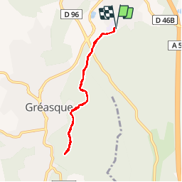
Tour Mountainbike von 6,7 km verfügbar auf Provence-Alpes-Côte d'Azur, Bouches-du-Rhône, Fuveau. Diese Tour wird von amiral13 vorgeschlagen.
Beschreibung
une petite balade en vélo, réalisée avec ma pitchoune de 6 ans; très contente de pouvoir jouer dans le cadre agréable du tombereau
Ort
Land:
France
Region :
Provence-Alpes-Côte d'Azur
Abteilung/Provinz :
Bouches-du-Rhône
Kommune :
Fuveau
Standort:
Unknown
Gehen Sie:(Dec)
Gehen Sie:(UTM)
707139 ; 4813541 (31T) N.
Kommentare
Touren in der Umgebung
![Mountainbike Mountainbike](https://static1.geolcdn.com/sitytour/trail-icons/202.png)
Le Regagnas par Belcodène retour par Kirbon et Les Michels D+715m
Mountainbike
Sehr schwierig
(1)
Fuveau,
Provence-Alpes-Côte d'Azur,
Bouches-du-Rhône,
France
![](/images/other/stat-length.png)
33 km | 43 km-effort
2h 59min
![](https://static1.geolcdn.com/siteimages/upload/files/16400158638029165_repeat_loop_refresh_sync_direction_icon.png)
Ja
![Wandern Wandern](https://static1.geolcdn.com/sitytour/trail-icons/101.png)
Canal par le chemin de fer
Wandern
Sehr schwierig
(1)
Fuveau,
Provence-Alpes-Côte d'Azur,
Bouches-du-Rhône,
France
![](/images/other/stat-length.png)
16,8 km | 21 km-effort
4h 40min
![](https://static1.geolcdn.com/siteimages/upload/files/16400158638029165_repeat_loop_refresh_sync_direction_icon.png)
Ja
![Mountainbike Mountainbike](https://static1.geolcdn.com/sitytour/trail-icons/202.png)
La corniche des 2 barrages de Ste Victoire
Mountainbike
Sehr schwierig
(1)
Fuveau,
Provence-Alpes-Côte d'Azur,
Bouches-du-Rhône,
France
![](/images/other/stat-length.png)
35 km | 45 km-effort
3h 7min
![](https://static1.geolcdn.com/siteimages/upload/files/16400158638029165_repeat_loop_refresh_sync_direction_icon.png)
Ja
![Rennrad Rennrad](https://static1.geolcdn.com/sitytour/trail-icons/201.png)
Vallée de l'Arc et retour par Pourrières Puyloubier Chateauneuf
Rennrad
Sehr schwierig
(1)
Fuveau,
Provence-Alpes-Côte d'Azur,
Bouches-du-Rhône,
France
![](/images/other/stat-length.png)
42 km | 47 km-effort
2h 52min
![](https://static1.geolcdn.com/siteimages/upload/files/16400158638029165_repeat_loop_refresh_sync_direction_icon.png)
Ja
![Mountainbike Mountainbike](https://static1.geolcdn.com/sitytour/trail-icons/202.png)
4 Termes, Chateau-bas, Siminane, Pilon, Col St-Anne, Mimet, Gréasque
Mountainbike
Sehr schwierig
(1)
Fuveau,
Provence-Alpes-Côte d'Azur,
Bouches-du-Rhône,
France
![](/images/other/stat-length.png)
36 km | 47 km-effort
3h 13min
![](https://static1.geolcdn.com/siteimages/upload/files/16400158638029165_repeat_loop_refresh_sync_direction_icon.png)
Ja
![Wandern Wandern](https://static1.geolcdn.com/sitytour/trail-icons/101.png)
La centrale photovoltaique par le chemin de fer
Wandern
Schwierig
(1)
Fuveau,
Provence-Alpes-Côte d'Azur,
Bouches-du-Rhône,
France
![](/images/other/stat-length.png)
10,1 km | 12,6 km-effort
2h 52min
![](https://static1.geolcdn.com/siteimages/upload/files/16400158638029165_repeat_loop_refresh_sync_direction_icon.png)
Ja
![Rennrad Rennrad](https://static1.geolcdn.com/sitytour/trail-icons/201.png)
Tour Ste Victoire D+1200m
Rennrad
Sehr schwierig
(1)
Fuveau,
Provence-Alpes-Côte d'Azur,
Bouches-du-Rhône,
France
![](/images/other/stat-length.png)
72 km | 88 km-effort
5h 21min
![](https://static1.geolcdn.com/siteimages/upload/files/16400158638029165_repeat_loop_refresh_sync_direction_icon.png)
Ja
![Mountainbike Mountainbike](https://static1.geolcdn.com/sitytour/trail-icons/202.png)
Fuveau, Regagnas, La Couelle, Kirbon, Les Michels, Fuveau D+790m
Mountainbike
Sehr schwierig
(1)
Fuveau,
Provence-Alpes-Côte d'Azur,
Bouches-du-Rhône,
France
![](/images/other/stat-length.png)
38 km | 49 km-effort
3h 24min
![](https://static1.geolcdn.com/siteimages/upload/files/16400158638029165_repeat_loop_refresh_sync_direction_icon.png)
Ja
![Rennrad Rennrad](https://static1.geolcdn.com/sitytour/trail-icons/201.png)
Maison de la Ste Victoire D+590m
Rennrad
Sehr schwierig
(1)
Fuveau,
Provence-Alpes-Côte d'Azur,
Bouches-du-Rhône,
France
![](/images/other/stat-length.png)
36 km | 44 km-effort
2h 40min
![](https://static1.geolcdn.com/siteimages/upload/files/16400158638029165_repeat_loop_refresh_sync_direction_icon.png)
Ja