![](/images/other/stat-length.png)
![Tour Wandern Waldbillig - le Mulerthael - Photo](https://media.geolcdn.com/t/1900/400/ext.pjpeg?maxdim=2&url=https%3A%2F%2Fstatic1.geolcdn.com%2Fsiteimages%2Fupload%2Ffiles%2F1553511878bg_sport_marche.png)
le Mulerthael
micheldutilleul
Benutzer
![Länge](/images/other/stat-length.png)
Länge
12 km
![Maximale Höhe](https://static1.geolcdn.com/siteimages/upload/files/1508320355ic_sort_altitude_max_24dp.png)
Maximale Höhe
355 m
![Positive Höhendifferenz](https://static1.geolcdn.com/siteimages/upload/files/1508320355ic_sort_den_pos_24dp.png)
Positive Höhendifferenz
318 m
![Km-Effort](/images/other/stat-length.png)
Km-Effort
16,2 km
![Min. Höhe](https://static1.geolcdn.com/siteimages/upload/files/1508320355ic_sort_altitude_min_24dp.png)
Min. Höhe
211 m
![Negative Höhendifferenz](https://static1.geolcdn.com/siteimages/upload/files/1508320355ic_sort_den_neg_24dp.png)
Negative Höhendifferenz
319 m
![Boucle](https://static1.geolcdn.com/siteimages/upload/files/16400158638029165_repeat_loop_refresh_sync_direction_icon.png)
Boucle
Ja
Erstellungsdatum :
2022-10-15 08:08:56.99
Letzte Änderung :
2022-10-16 14:03:59.216
![Wandern](https://static1.geolcdn.com/sitytour/trail-icons/101.png)
3h30
Schwierigkeit : Medium
![Scannen Sie diesen QR-Code, um die Tour in der SityTrail-Anwendung zu öffnen](https://capi.geolives.com/qq0zvz2zws4bq2lad0pu/sitytour/trails/3425733/qr.png?size=200)
Kostenlosegpshiking-Anwendung
Über SityTrail
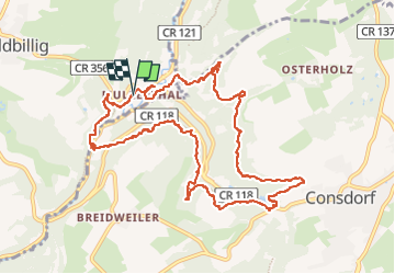
Tour Wandern von 12 km verfügbar auf Unbekannt, Kanton Echternach, Waldbillig. Diese Tour wird von micheldutilleul vorgeschlagen.
Beschreibung
Magnifique balade dans les bois ( rocher, cascade, passage dans la roche,...).
Attention, chemins glissant par temps de pluie, bonnes chaussures de marché conseillées.
Ort
Land:
Luxembourg
Region :
Unbekannt
Abteilung/Provinz :
Kanton Echternach
Kommune :
Waldbillig
Standort:
Unknown
Gehen Sie:(Dec)
Gehen Sie:(UTM)
306078 ; 5518789 (32U) N.
Kommentare
Touren in der Umgebung
![Tour Wandern Waldbillig - 2024-08-10_15h10m00_Sentier_local_-_W4 - Photo](https://media.geolcdn.com/t/375/260/d315698e-faa8-4cbd-932a-8a7221249730.jpg&format=jpg&maxdim=2)
![Wandern Wandern](https://static1.geolcdn.com/sitytour/trail-icons/101.png)
2024-08-10_15h10m00_Sentier_local_-_W4
Wandern
Medium
(1)
Waldbillig,
Unbekannt,
Kanton Echternach,
Luxembourg
![](/images/other/stat-length.png)
6,2 km | 7,8 km-effort
1h 45min
![](https://static1.geolcdn.com/siteimages/upload/files/16400158638029165_repeat_loop_refresh_sync_direction_icon.png)
Ja
![Tour Wandern Consdorf - 2023-06-19_09h33m43_Sentier_local_-_C6 - Photo](https://media.geolcdn.com/t/375/260/1a93b691-9fc1-4ff8-ae1a-57fcf6e1418e.jpg&format=jpg&maxdim=2)
![Wandern Wandern](https://static1.geolcdn.com/sitytour/trail-icons/101.png)
2023-06-19_09h33m43_Sentier_local_-_C6
Wandern
Medium
(1)
Consdorf,
Unbekannt,
Kanton Echternach,
Luxembourg
![](/images/other/stat-length.png)
5,8 km | 7,3 km-effort
1h 39min
![](https://static1.geolcdn.com/siteimages/upload/files/16400158638029165_repeat_loop_refresh_sync_direction_icon.png)
Ja
![Tour Wandern Consdorf - 2023-06-13_20h43m48_Sentier_local_-_C2 - Photo](https://media.geolcdn.com/t/375/260/0cc79ac2-8683-4672-970a-cfe76e408507.jpg&format=jpg&maxdim=2)
![Wandern Wandern](https://static1.geolcdn.com/sitytour/trail-icons/101.png)
2023-06-13_20h43m48_Sentier_local_-_C2
Wandern
Einfach
(1)
Consdorf,
Unbekannt,
Kanton Echternach,
Luxembourg
![](/images/other/stat-length.png)
4,2 km | 5,5 km-effort
1h 15min
![](https://static1.geolcdn.com/siteimages/upload/files/16400158638029165_repeat_loop_refresh_sync_direction_icon.png)
Ja
![Tour Wandern Consdorf - 2023-06-13_20h03m09_Circuit_auto-pdestre_Consdorf_-_Mullerthal - Photo](https://media.geolcdn.com/t/375/260/43e83e22-9e28-4a45-bf58-3588aa9e8a2f.jpg&format=jpg&maxdim=2)
![Wandern Wandern](https://static1.geolcdn.com/sitytour/trail-icons/101.png)
2023-06-13_20h03m09_Circuit_auto-pdestre_Consdorf_-_Mullerthal
Wandern
Medium
(2)
Consdorf,
Unbekannt,
Kanton Echternach,
Luxembourg
![](/images/other/stat-length.png)
9 km | 12,3 km-effort
2h 48min
![](https://static1.geolcdn.com/siteimages/upload/files/16400158638029165_repeat_loop_refresh_sync_direction_icon.png)
Ja
![Tour Wandern Berdorf - Berdorf - B2 - Müllerthal - Photo](https://media.geolcdn.com/t/375/260/517daf86-eb8b-412e-9a7e-d0a346807e81.jpg&format=jpg&maxdim=2)
![Wandern Wandern](https://static1.geolcdn.com/sitytour/trail-icons/101.png)
Berdorf - B2 - Müllerthal
Wandern
Medium
(2)
Berdorf,
Unbekannt,
Kanton Echternach,
Luxembourg
![](/images/other/stat-length.png)
6,7 km | 8,5 km-effort
1h 35min
![](https://static1.geolcdn.com/siteimages/upload/files/16400158638029165_repeat_loop_refresh_sync_direction_icon.png)
Ja
![Tour Wandern Befort - 2021-07-05_20h10m00_gpx-file (1) - Photo](https://media.geolcdn.com/t/375/260/9b40ebf8-55f0-408d-8504-76ef1490c879.jpg&format=jpg&maxdim=2)
![Wandern Wandern](https://static1.geolcdn.com/sitytour/trail-icons/101.png)
2021-07-05_20h10m00_gpx-file (1)
Wandern
Medium
(1)
Befort,
Unbekannt,
Kanton Echternach,
Luxembourg
![](/images/other/stat-length.png)
10,6 km | 13,6 km-effort
3h 5min
![](https://static1.geolcdn.com/siteimages/upload/files/16400158638029165_repeat_loop_refresh_sync_direction_icon.png)
Ja
![Tour Wandern Waldbillig - Mullerthal randonnée magnifique - Photo](https://media.geolcdn.com/t/375/260/3f58fb00-23e0-4e5f-be44-94a05c44c601.jpg&format=jpg&maxdim=2)
![Wandern Wandern](https://static1.geolcdn.com/sitytour/trail-icons/101.png)
Mullerthal randonnée magnifique
Wandern
Schwierig
(4)
Waldbillig,
Unbekannt,
Kanton Echternach,
Luxembourg
![](/images/other/stat-length.png)
9,3 km | 12,9 km-effort
4h 21min
![](https://static1.geolcdn.com/siteimages/upload/files/16400158638029165_repeat_loop_refresh_sync_direction_icon.png)
Ja
![Tour Wandern Consdorf - 2023-06-21_17h04m10_Sentier_local_-_C1 (1) - Photo](https://media.geolcdn.com/t/375/260/67bec963-192a-46c1-a89d-070dac0d9ebc.jpg&format=jpg&maxdim=2)
![Wandern Wandern](https://static1.geolcdn.com/sitytour/trail-icons/101.png)
2023-06-21_17h04m10_Sentier_local_-_C1 (1)
Wandern
Einfach
(1)
Consdorf,
Unbekannt,
Kanton Echternach,
Luxembourg
![](/images/other/stat-length.png)
1,9 km | 2,5 km-effort
34min
![](https://static1.geolcdn.com/siteimages/upload/files/16400158638029165_repeat_loop_refresh_sync_direction_icon.png)
Ja
![Tour Wandern Berdorf - 2023-06-03_18h17m36_Sentier_local_-_B8 - Photo](https://media.geolcdn.com/t/375/260/7a8870ac-d558-4a39-b7c2-bdeb26e936c0.jpg&format=jpg&maxdim=2)
![Wandern Wandern](https://static1.geolcdn.com/sitytour/trail-icons/101.png)
2023-06-03_18h17m36_Sentier_local_-_B8
Wandern
Medium
(2)
Berdorf,
Unbekannt,
Kanton Echternach,
Luxembourg
![](/images/other/stat-length.png)
11,7 km | 15 km-effort
3h 24min
![](https://static1.geolcdn.com/siteimages/upload/files/16400158638029165_repeat_loop_refresh_sync_direction_icon.png)
Ja