![](/images/other/stat-length.png)
![Tour Mountainbike Saint-Lambert-la-Potherie - Sortie matinale - Photo](https://media.geolcdn.com/t/1900/400/ext.pjpeg?maxdim=2&url=https%3A%2F%2Fstatic1.geolcdn.com%2Fsiteimages%2Fupload%2Ffiles%2F1524743154velo.jpg)
Sortie matinale
fab71
Benutzer
![Länge](/images/other/stat-length.png)
Länge
37 km
![Maximale Höhe](https://static1.geolcdn.com/siteimages/upload/files/1508320355ic_sort_altitude_max_24dp.png)
Maximale Höhe
82 m
![Positive Höhendifferenz](https://static1.geolcdn.com/siteimages/upload/files/1508320355ic_sort_den_pos_24dp.png)
Positive Höhendifferenz
299 m
![Km-Effort](/images/other/stat-length.png)
Km-Effort
41 km
![Min. Höhe](https://static1.geolcdn.com/siteimages/upload/files/1508320355ic_sort_altitude_min_24dp.png)
Min. Höhe
9 m
![Negative Höhendifferenz](https://static1.geolcdn.com/siteimages/upload/files/1508320355ic_sort_den_neg_24dp.png)
Negative Höhendifferenz
316 m
![Boucle](https://static1.geolcdn.com/siteimages/upload/files/16400158638029165_repeat_loop_refresh_sync_direction_icon.png)
Boucle
Nein
Erstellungsdatum :
2014-12-10 00:00:00.0
Letzte Änderung :
2014-12-10 00:00:00.0
![Mountainbike](https://static1.geolcdn.com/sitytour/trail-icons/202.png)
2h04
Schwierigkeit : Einfach
![Scannen Sie diesen QR-Code, um die Tour in der SityTrail-Anwendung zu öffnen](https://capi.geolives.com/qq0zvz2zws4bq2lad0pu/sitytour/trails/341730/qr.png?size=200)
Kostenlosegpshiking-Anwendung
Über SityTrail
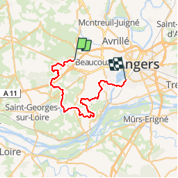
Tour Mountainbike von 37 km verfügbar auf Pays de la Loire, Maine-et-Loire, Saint-Lambert-la-Potherie. Diese Tour wird von fab71 vorgeschlagen.
Beschreibung
St-Lambert la Potherie, Saint-Léger-des-Bois, Saint-Martin-du-Fouilloux, Angers
Ort
Land:
France
Region :
Pays de la Loire
Abteilung/Provinz :
Maine-et-Loire
Kommune :
Saint-Lambert-la-Potherie
Standort:
Unknown
Gehen Sie:(Dec)
Gehen Sie:(UTM)
674986 ; 5260955 (30T) N.
Kommentare
Touren in der Umgebung
![Tour Wandern Saint-Léger-de-Linières - saint Léger des Bois - Photo](https://media.geolcdn.com/t/375/260/f9d8b165-8ea1-4944-8d0e-24eb9455c06a.jpg&format=jpg&maxdim=2)
![Wandern Wandern](https://static1.geolcdn.com/sitytour/trail-icons/101.png)
saint Léger des Bois
Wandern
Einfach
Saint-Léger-de-Linières,
Pays de la Loire,
Maine-et-Loire,
France
![](/images/other/stat-length.png)
10,5 km | 11,6 km-effort
2h 46min
![](https://static1.geolcdn.com/siteimages/upload/files/16400158638029165_repeat_loop_refresh_sync_direction_icon.png)
Ja
![Tour Reiten Beaucouzé - EQUIRANDO_2021_ITINERAIRE_03_SUDOUEST (1) - Photo](https://media.geolcdn.com/t/375/260/ext.jpg?maxdim=2&url=https%3A%2F%2Fstatic1.geolcdn.com%2Fsiteimages%2Fupload%2Ffiles%2F1524743154cheval.jpg)
![Reiten Reiten](https://static1.geolcdn.com/sitytour/trail-icons/301.png)
EQUIRANDO_2021_ITINERAIRE_03_SUDOUEST (1)
Reiten
Medium
Beaucouzé,
Pays de la Loire,
Maine-et-Loire,
France
![](/images/other/stat-length.png)
28 km | 31 km-effort
4h 6min
![](https://static1.geolcdn.com/siteimages/upload/files/16400158638029165_repeat_loop_refresh_sync_direction_icon.png)
Nein
![Tour Wandern Saint-Léger-de-Linières - Saint léger des bois - Photo](https://media.geolcdn.com/t/375/260/46d01622-b82b-4936-afde-3d1007f3ac17.jpg&format=jpg&maxdim=2)
![Wandern Wandern](https://static1.geolcdn.com/sitytour/trail-icons/101.png)
Saint léger des bois
Wandern
Saint-Léger-de-Linières,
Pays de la Loire,
Maine-et-Loire,
France
![](/images/other/stat-length.png)
10,9 km | 12 km-effort
2h 20min
![](https://static1.geolcdn.com/siteimages/upload/files/16400158638029165_repeat_loop_refresh_sync_direction_icon.png)
Ja
![Tour Wandern Beaucouzé - Étang Saint-Nicolas - le tour - Photo](https://media.geolcdn.com/t/375/260/052aad22-966b-4a3e-9d4f-b575cbb99b14.jpg&format=jpg&maxdim=2)
![Wandern Wandern](https://static1.geolcdn.com/sitytour/trail-icons/101.png)
Étang Saint-Nicolas - le tour
Wandern
Einfach
Beaucouzé,
Pays de la Loire,
Maine-et-Loire,
France
![](/images/other/stat-length.png)
10,1 km | 11,2 km-effort
2h 41min
![](https://static1.geolcdn.com/siteimages/upload/files/16400158638029165_repeat_loop_refresh_sync_direction_icon.png)
Ja
![Tour Hybrid-Bike Bouchemaine - Bouchemaine chez Denis chez Yann - Photo](https://media.geolcdn.com/t/375/260/ext.jpg?maxdim=2&url=https%3A%2F%2Fstatic1.geolcdn.com%2Fsiteimages%2Fupload%2Ffiles%2F1524743154velo.jpg)
![Hybrid-Bike Hybrid-Bike](https://static1.geolcdn.com/sitytour/trail-icons/203.png)
Bouchemaine chez Denis chez Yann
Hybrid-Bike
Sehr leicht
Bouchemaine,
Pays de la Loire,
Maine-et-Loire,
France
![](/images/other/stat-length.png)
58 km | 64 km-effort
4h 39min
![](https://static1.geolcdn.com/siteimages/upload/files/16400158638029165_repeat_loop_refresh_sync_direction_icon.png)
Ja
![Tour Laufen Saint-Lambert-la-Potherie - footing #Linieroise# - Photo](https://media.geolcdn.com/t/375/260/ext.jpg?maxdim=2&url=https%3A%2F%2Fstatic1.geolcdn.com%2Fsiteimages%2Fupload%2Ffiles%2F1524743154running.jpg)
![Laufen Laufen](https://static1.geolcdn.com/sitytour/trail-icons/103.png)
footing #Linieroise#
Laufen
Einfach
Saint-Lambert-la-Potherie,
Pays de la Loire,
Maine-et-Loire,
France
![](/images/other/stat-length.png)
12,8 km | 14,3 km-effort
1h 15min
![](https://static1.geolcdn.com/siteimages/upload/files/16400158638029165_repeat_loop_refresh_sync_direction_icon.png)
Ja
![Tour Andere Aktivitäten Saint-Léger-de-Linières - St J. de Linières - Beaupreau - Photo](https://media.geolcdn.com/t/375/260/ext.jpg?maxdim=2&url=https%3A%2F%2Fstatic1.geolcdn.com%2Fsiteimages%2Fupload%2Ffiles%2F1545311037marcheuse_200dpi.jpg)
![Andere Aktivitäten Andere Aktivitäten](https://static1.geolcdn.com/sitytour/trail-icons/900.png)
St J. de Linières - Beaupreau
Andere Aktivitäten
Sehr leicht
Saint-Léger-de-Linières,
Pays de la Loire,
Maine-et-Loire,
France
![](/images/other/stat-length.png)
47 km | 52 km-effort
Unbekannt
![](https://static1.geolcdn.com/siteimages/upload/files/16400158638029165_repeat_loop_refresh_sync_direction_icon.png)
Nein
![Tour Mountainbike Bouchemaine - Circuit des 2 rivières - Bouchemaine & Savennières - Photo](https://media.geolcdn.com/t/375/260/ext.jpg?maxdim=2&url=https%3A%2F%2Fstatic1.geolcdn.com%2Fsiteimages%2Fupload%2Ffiles%2F1524743154velo.jpg)
![Mountainbike Mountainbike](https://static1.geolcdn.com/sitytour/trail-icons/202.png)
Circuit des 2 rivières - Bouchemaine & Savennières
Mountainbike
Medium
Bouchemaine,
Pays de la Loire,
Maine-et-Loire,
France
![](/images/other/stat-length.png)
27 km | 30 km-effort
1h 30min
![](https://static1.geolcdn.com/siteimages/upload/files/16400158638029165_repeat_loop_refresh_sync_direction_icon.png)
Ja
![Tour Nordic Walking Saint-Lambert-la-Potherie - St Lambert -St Leger - Photo](https://media.geolcdn.com/t/375/260/ext.jpg?maxdim=2&url=https%3A%2F%2Fstatic1.geolcdn.com%2Fsiteimages%2Fupload%2Ffiles%2F1545311037marcheuse_200dpi.jpg)
![Nordic Walking Nordic Walking](https://static1.geolcdn.com/sitytour/trail-icons/102.png)
St Lambert -St Leger
Nordic Walking
Einfach
Saint-Lambert-la-Potherie,
Pays de la Loire,
Maine-et-Loire,
France
![](/images/other/stat-length.png)
16,7 km | 18,3 km-effort
2h 53min
![](https://static1.geolcdn.com/siteimages/upload/files/16400158638029165_repeat_loop_refresh_sync_direction_icon.png)
Ja